$4,200
Total Monthly Price
12 Month Lease
675 Grove St
Newton, MA 02462
Favorites
-
Bedrooms
3
-
Bathrooms
3
-
Square Feet
1,760 sq ft
-
Available
Available Jun 1
Highlight
- Basement
675 Grove St

Favorites
About This Home
12 Month Lease,
$4,200 deposit,
Available Jun 1
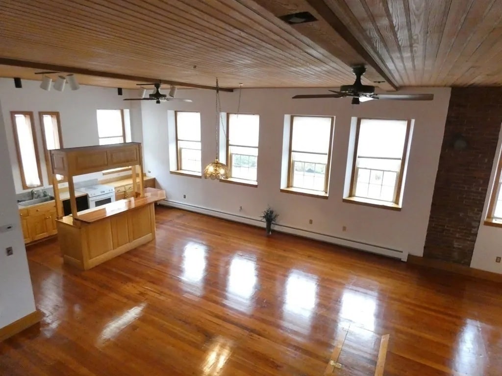
CONVERTED FIRE HOUSE RESIDENCE HISTORICAL CHARM ABOUND! Available June 1, 2026: Nestled in the Newton's Historic Lower Falls District is a unique 3-bedroom, 2-bath, converted Fire House (circa '1900') residence, with 2 dedicated off street parking spaces, high ceilings with lots of windows, brick and wood surroundings. Access to public transportation is a 10-minute walk to the MBTA Green Line (D) at Riverside and a 15-minute walk to the Commuter Rail at Wellesley Farms Station; if driving, the Mass. Turnpike and Rte. 128 (Interstate 95) is 3 to 4 minutes away. Also, a10 minute walk to Newton-Wellesley Hospital (MGB). The residence is heated by forced hot water base board, fired by a natural gas boiler, which also provides domestic hot water. Full basement laundry and lots of storage space. Utilities are not included and, pets and smoking are not allowed. Monthly rent is $4,200.00. Co-broke welcome.
675 Grove St is a townhome located in Middlesex County and the 02462 ZIP Code. This area is served by the Newton School District attendance zone.
* Price shown is total price based on community-supplied monthly required fees. Excludes user-selected optional fees and variable or usage-based fees and required charges due at or prior to move-in or at move-out. Price, availability, fees, and any applicable rent special are subject to change without notice.
* Square footage definitions vary. Displayed square footage is approximate.
Townhome Features
- Instant Hot Water
- High Ceilings
- Basement
- Storage Space
Contact
- Contact
Location
Get Directions
Located seven miles west of downtown Boston, Newton combines residential comfort with easy city access. Known as "The Garden City," this community features tree-lined streets, expansive parks, and thirteen distinct villages. The housing market reflects the area's desirability, with current average rents ranging from $2,415 for studios to $4,899 for three-bedroom homes. Crystal Lake offers swimming and outdoor recreation, while the historic Heartbreak Hill, a challenging section of the Boston Marathon route, provides scenic views of the area.
Newton's educational landscape includes Boston College's Gothic campus in Chestnut Hill and highly regarded public schools. Housing options span from apartments near MBTA stations in Newton Centre to historic Victorian homes in West Newton and contemporary residences in Newtonville. The Newton History Museum at Jackson Homestead, a documented Underground Railroad site, preserves local history.
Learn more about living in Newton
Education
| Colleges & Universities | Distance | ||
|---|---|---|---|
| Colleges & Universities | Distance | ||
| Drive: | 8 min | 3.4 mi | |
| Drive: | 9 min | 3.7 mi | |
| Drive: | 10 min | 4.2 mi | |
| Drive: | 12 min | 6.0 mi |
675 Grove St is within 9 minutes or 3.7 miles from Babson College. It is also near Brandeis University and Wellesley College.
Schools


Public Elementary School
Grades K-5
381 Students
Attendance Zone
Public Elementary School
Grades PK-5
396 Students
Nearby
Public Middle School
Grades 6-8
698 Students
Attendance Zone
Public High School
Grades 9-12
1,865 Students
Attendance Zone
Private Elementary School
Grades PK-5
217 Students
Nearby
Private Elementary & Middle School
Grades PK-8
315 Students
Nearby
Private Elementary, Middle & High School
Grades K-12
8 Students
Nearby
School data provided by
 The GreatSchools Rating helps parents compare schools within a state based on a variety of school quality indicators and provides a helpful picture of how effectively each school serves all of its students. Ratings are on a scale of 1 (below average) to 10 (above average) and can include test scores, college readiness, academic progress, advanced courses, equity, discipline and attendance data. We also advise parents to visit schools, consider other information on school performance and programs, and consider family needs as part of the school selection process.
View GreatSchools Rating Methodology
Data provided by GreatSchools.org © 2026. All rights reserved.
View GreatSchools Rating Methodology
Data provided by GreatSchools.org © 2026. All rights reserved.
Transportation options available in Newton include Riverside Station, located 1.0 mile from 675 Grove St. 675 Grove St is near General Edward Lawrence Logan International, located 15.3 miles or 25 minutes away, and Worcester Regional, located 38.9 miles or 56 minutes away.
| Transit / Subway | Distance | ||
|---|---|---|---|
| Transit / Subway | Distance | ||
|
|
Walk: | 18 min | 1.0 mi |
|
|
Drive: | 3 min | 1.4 mi |
|
|
Drive: | 4 min | 2.0 mi |
|
|
Drive: | 7 min | 3.1 mi |
|
|
Drive: | 7 min | 3.3 mi |
| Commuter Rail | Distance | ||
|---|---|---|---|
| Commuter Rail | Distance | ||
|
|
Drive: | 3 min | 1.1 mi |
|
|
Drive: | 4 min | 1.8 mi |
|
|
Drive: | 6 min | 3.0 mi |
|
|
Drive: | 13 min | 7.5 mi |
|
|
Drive: | 14 min | 8.3 mi |
| Airports | Distance | ||
|---|---|---|---|
| Airports | Distance | ||
|
General Edward Lawrence Logan International
|
Drive: | 25 min | 15.3 mi |
|
Worcester Regional
|
Drive: | 56 min | 38.9 mi |
Getting Around
 What do Walkability, Transit, Drivability, and Bikeability mean?
Walkability measures the walking distance to day-to-day needs.
Transit measures access to public transportation.
Drivability measures congestion, parking availability, and access to major roads.
Bikeability measures the suitability for cycling.
How It Works
What do Walkability, Transit, Drivability, and Bikeability mean?
Walkability measures the walking distance to day-to-day needs.
Transit measures access to public transportation.
Drivability measures congestion, parking availability, and access to major roads.
Bikeability measures the suitability for cycling.
How It Works
Fairly Walkable
Walkability
50
/ 100
Some Public Transit
Transit
40
/ 100
Exceptionally Drivable
Drivability
90
/ 100
Fairly Bikeable
Bikeability
40
/ 100
Scores provided by
-
Soundscore™
-
/ 100
Traffic
-Airport
-Businesses
-Scores provided by
HowLoud What is a Sound Score Rating? A Sound Score Rating aggregates noise caused by vehicle traffic, airplane traffic and local sources. How It WorksTime and distance from 675 Grove St.
| Shopping Centers | Distance | ||
|---|---|---|---|
| Shopping Centers | Distance | ||
| Drive: | 5 min | 1.9 mi | |
| Drive: | 6 min | 2.7 mi | |
| Drive: | 6 min | 2.9 mi |
675 Grove St has 3 shopping centers within 2.9 miles, which is about a 6-minute drive. The miles and minutes will be for the farthest away property.
| Parks and Recreation | Distance | ||
|---|---|---|---|
| Parks and Recreation | Distance | ||
|
Hemlock Gorge Reservation
|
Drive: | 8 min | 3.5 mi |
|
Land's Sake Farm
|
Drive: | 8 min | 3.5 mi |
|
Whitin Observatory
|
Drive: | 8 min | 3.6 mi |
|
Wellesley College Botanic Gardens
|
Drive: | 7 min | 3.9 mi |
|
Cutler Park Reservation
|
Drive: | 8 min | 4.2 mi |
675 Grove St has 5 parks within 4.2 miles, including Hemlock Gorge Reservation, Whitin Observatory, and Land's Sake Farm.
| Hospitals | Distance | ||
|---|---|---|---|
| Hospitals | Distance | ||
| Walk: | 14 min | 0.7 mi | |
| Drive: | 8 min | 3.9 mi | |
| Drive: | 9 min | 5.0 mi |
675 Grove St has 3 hospitals within 5.0 miles, the nearest is Newton - Wellesley Hospital which is 0.7 mile away and a 14 minute walk.
| Military Bases | Distance | ||
|---|---|---|---|
| Military Bases | Distance | ||
| Drive: | 13 min | 7.2 mi | |
| Drive: | 20 min | 10.6 mi | |
| Drive: | 50 min | 30.0 mi |
675 Grove St has 3 military bases within 30.0 miles, the nearest is US Military Reservation which is 7.2 miles away and a 13 minute drive.
Amenities
- Instant Hot Water
- High Ceilings
- Basement
- Storage Space
675 Grove St Photos
What Are Walk Score®, Transit Score®, and Bike Score® Ratings?
Walk Score® measures the walkability of any address. Transit Score® measures access to public transit. Bike Score® measures the bikeability of any address.
What is a Sound Score Rating?
A Sound Score Rating aggregates noise caused by vehicle traffic, airplane traffic and local sources.

675 Grove St
Newton, MA 02462