
$2,200
Total Monthly Price
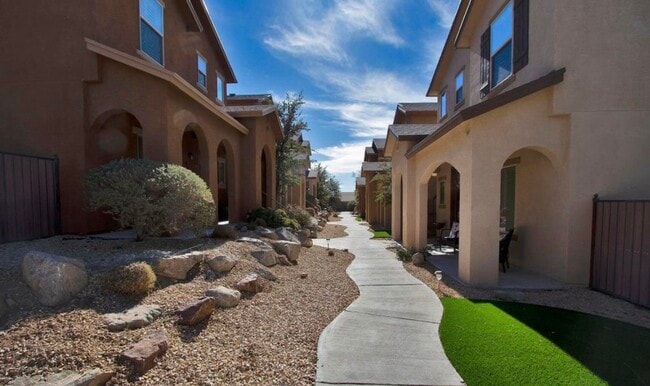
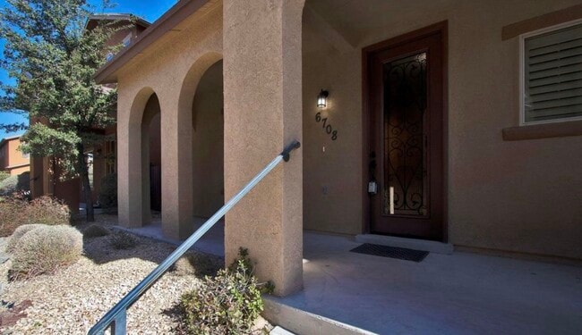
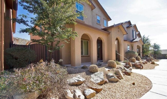
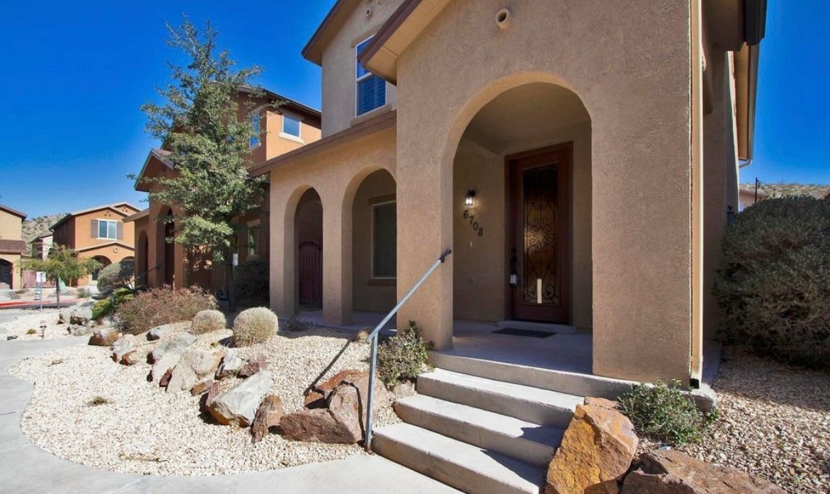
6708 Red Canyon Sage Ln
El Paso, TX 79912
Favorites
-
Bedrooms
3
-
Bathrooms
2.5
-
Square Feet
1,756 sq ft
-
Available
Available Now
Highlights
- Pets Allowed
- Double Vanities
6708 Red Canyon Sage Ln

Favorites
About This Home
12 Month Lease,
$2,200 deposit,
Available Now
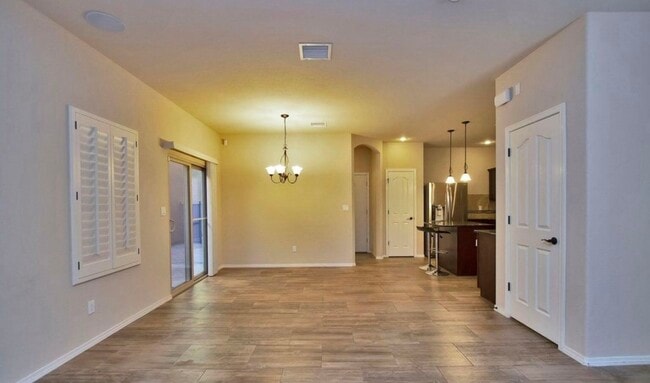
Beautiful rental home located in a desirable semi-private neighborhood, offering both comfort and convenience. Ideally situated near Westwind and Belvidere, this property boasts an excellent location with easy access to schools, gyms, shopping centers, and a wide variety of restaurants. The home provides a peaceful living environment while still being close to everything you need for everyday life. Perfect for families or professionals looking for a well-connected and comfortable place to call home. Don't miss this opportunity to live in a great location with convenience at your doorstep!
6708 Red Canyon Sage Ln is a house located in El Paso County and the 79912 ZIP Code. This area is served by the El Paso Independent School District attendance zone.
* Price shown is total price based on community-supplied monthly required fees. Excludes user-selected optional fees and variable or usage-based fees and required charges due at or prior to move-in or at move-out. Price, availability, fees, and any applicable rent special are subject to change without notice.
* Square footage definitions vary. Displayed square footage is approximate.
House Features
Washer/Dryer
Tub/Shower
Ceiling Fans
Heating
- Washer/Dryer
- Heating
- Ceiling Fans
- Storage Space
- Double Vanities
- Tub/Shower
Fees and Policies
The fees listed below are community-provided and may exclude utilities or add-ons. All payments are made directly to the property and are non-refundable unless otherwise specified.
- Dogs Allowed
-
Fees not specified
- Cats Allowed
-
Fees not specified
- Parking
-
Garage--
Details
Utilities Included
-
Gas
-
Water
-
Electricity
-
Heat
-
Trash Removal
-
Sewer
-
Air Conditioning
Property Information
-
Built in 2016
Contact
- Contact
Location
Get Directions
El Paso sits where West Texas, New Mexico, and the Mexican state of Chihuahua converge, giving the city a cross-border identity that shapes everything from its architecture to its daily rhythm. With the Franklin Mountains rising inside city limits and the Rio Grande forming its southern edge, the geography alone sets it apart from anywhere else in Texas. Fort Bliss, one of the largest U.S. Army installations in the country, and the University of Texas at El Paso are two of the city's most significant economic and institutional anchors. The Chamizal National Memorial marks the site of a peacefully resolved international border dispute, a piece of history few American cities can claim.
Neighborhoods range widely in character. Manhattan Heights offers historic homes close to downtown, while Northeast El Paso spreads out with newer residential development near Fort Bliss. Kern Place, adjacent to UTEP's campus, has an established, walkable feel.
Learn more about living in El Paso
Education
| Colleges & Universities | Distance | ||
|---|---|---|---|
| Colleges & Universities | Distance | ||
| Drive: | 13 min | 6.6 mi | |
| Drive: | 14 min | 6.9 mi | |
| Drive: | 15 min | 7.8 mi | |
| Drive: | 28 min | 16.2 mi |
6708 Red Canyon Sage Ln is within 13 minutes or 6.6 miles from El Paso C.C., Northwest Campus. It is also near UT El Paso and El Paso C.C., Rio Grande.
Schools


Public Elementary School
Grades PK-5
627 Students
Attendance Zone
Public Middle School
Grades 6-8
1,296 Students
Attendance Zone
Public High School
Grades 9-12
3,149 Students
Attendance Zone
Private Elementary, Middle & High School
Grades PK-12
110 Students
Nearby
Private Elementary School
Grades PK-5
Nearby
School data provided by
 The GreatSchools Rating helps parents compare schools within a state based on a variety of school quality indicators and provides a helpful picture of how effectively each school serves all of its students. Ratings are on a scale of 1 (below average) to 10 (above average) and can include test scores, college readiness, academic progress, advanced courses, equity, discipline and attendance data. We also advise parents to visit schools, consider other information on school performance and programs, and consider family needs as part of the school selection process.
View GreatSchools Rating Methodology
Data provided by GreatSchools.org © 2026. All rights reserved.
View GreatSchools Rating Methodology
Data provided by GreatSchools.org © 2026. All rights reserved.
Getting Around
 What do Walkability, Transit, Drivability, and Bikeability mean?
Walkability measures the walking distance to day-to-day needs.
Transit measures access to public transportation.
Drivability measures congestion, parking availability, and access to major roads.
Bikeability measures the suitability for cycling.
How It Works
What do Walkability, Transit, Drivability, and Bikeability mean?
Walkability measures the walking distance to day-to-day needs.
Transit measures access to public transportation.
Drivability measures congestion, parking availability, and access to major roads.
Bikeability measures the suitability for cycling.
How It Works
Fairly Walkable
Walkability
50
/ 100
Limited Public Transit
Transit
30
/ 100
Very Drivable
Drivability
80
/ 100
Fairly Bikeable
Bikeability
40
/ 100
Scores provided by
Active
Soundscore™
76
/ 100
Traffic
ActiveAirport
CalmBusinesses
CalmScores provided by
HowLoud What is a Sound Score Rating? A Sound Score Rating aggregates noise caused by vehicle traffic, airplane traffic and local sources. How It Works
Amenities
- Washer/Dryer
- Heating
- Ceiling Fans
- Storage Space
- Double Vanities
- Tub/Shower
6708 Red Canyon Sage Ln Photos
What Are Walk Score®, Transit Score®, and Bike Score® Ratings?
Walk Score® measures the walkability of any address. Transit Score® measures access to public transit. Bike Score® measures the bikeability of any address.
What is a Sound Score Rating?
A Sound Score Rating aggregates noise caused by vehicle traffic, airplane traffic and local sources.
6708 Red Canyon Sage Ln
El Paso, TX 79912