
-
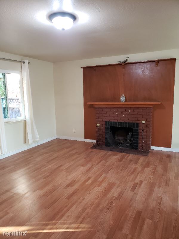
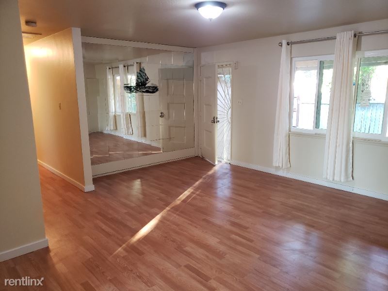
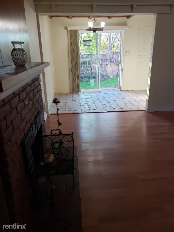
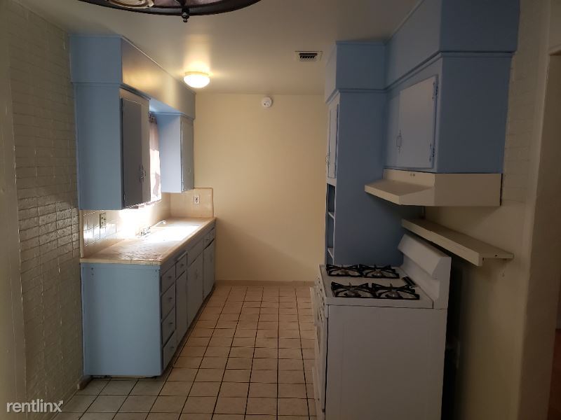
3 br, 2 bath House - 6701 Austin Way
-
-
-
$2,095
/ Month
6701 Austin Way
Sacramento, CA 95823
2 Weeks Ago
|
Edit
Favorites
6701 Austin Way

Favorites
Check Back Soon for Upcoming Availability
| Beds | Baths | Average SF |
|---|---|---|
| 3 Bedrooms 3 Bedrooms 3 Br | 2 Baths 2 Baths 2 Ba | — |
Fees and Policies
The fees listed below are community-provided and may exclude utilities or add-ons. All payments are made directly to the property and are non-refundable unless otherwise specified.
About This Property
(408) 834-5775 - 6701 Austin Way - Property Id: 631961 3 bedroom / 2 bath Nice and clean house Near freeway Large corner lot Apply at TurboTenant: http://rental.turbotenant.com/p/6701-austin-way-sacramento-ca/631961 Property Id 631961 No Pets Allowed (RLNE7322689) Lease lengths: 12 Months. Pet policies: No Dogs Allowed, No Pets Allowed.
6701 Austin Way is a house located in Sacramento County and the 95823 ZIP Code. This area is served by the Sacramento City Unified School District attendance zone.
Unique Features
- No Dogs Allowed, No Pets Allowed
6701 Austin Way,
Sacramento,
CA
95823
Parkway-South Sacramento is an area less than 10 miles south of the heart of Sacramento surrounded by great amenities like Sacramento Executive Airport, Sacramento Zoo, and top-notch medical centers. But the community itself has a lot to offer. Split by Highway 99, the town is a mix of residential, retail, and industrial. Repair shops, building suppliers, and auto shops make up the western portion of town in Southgate Industrial Park while an abundance of retailers are situated right below in the Southgate Commercial District. The rest of the area is mainly residential with peaceful neighborhoods making up the western sections of town with a variety of moderately priced apartments to choose from.
Learn more about living in Parkway-South SacramentoBelow are rent ranges for similar nearby apartments
Amenities
- No Dogs Allowed, No Pets Allowed
Education
| Colleges & Universities | Distance | ||
|---|---|---|---|
| Colleges & Universities | Distance | ||
| Drive: | 8 min | 4.4 mi | |
| Drive: | 10 min | 5.3 mi | |
| Drive: | 11 min | 5.7 mi | |
| Drive: | 22 min | 15.3 mi |
6701 Austin Way is within 8 minutes or 4.4 miles from Sacramento City College. It is also near Cosumnes River College and Sacramento State.
Schools


Public Elementary School
Grades K-5
450 Students
Nearby
Public Elementary School
Grades K-5
482 Students
Attendance Zone
Public Middle School
Grades 6-8
679 Students
Attendance Zone
Public High School
Grades 9-12
1,682 Students
Attendance Zone
Private Elementary & Middle School
Grades PK-8
Nearby
Private Elementary, Middle & High School
Grades PK-12
459 Students
Nearby
School data provided by
 The GreatSchools Rating helps parents compare schools within a state based on a variety of school quality indicators and provides a helpful picture of how effectively each school serves all of its students. Ratings are on a scale of 1 (below average) to 10 (above average) and can include test scores, college readiness, academic progress, advanced courses, equity, discipline and attendance data. We also advise parents to visit schools, consider other information on school performance and programs, and consider family needs as part of the school selection process.
View GreatSchools Rating Methodology
Data provided by GreatSchools.org © 2026. All rights reserved.
View GreatSchools Rating Methodology
Data provided by GreatSchools.org © 2026. All rights reserved.
Transportation options available in Sacramento include 47Th Avenue, located 2.3 miles from 6701 Austin Way. 6701 Austin Way is near Sacramento International, located 18.6 miles or 27 minutes away.
| Transit / Subway | Distance | ||
|---|---|---|---|
| Transit / Subway | Distance | ||
|
|
Drive: | 5 min | 2.3 mi |
|
|
Drive: | 5 min | 2.6 mi |
|
|
Drive: | 6 min | 3.3 mi |
|
|
Drive: | 8 min | 3.7 mi |
| Drive: | 12 min | 4.7 mi |
| Commuter Rail | Distance | ||
|---|---|---|---|
| Commuter Rail | Distance | ||
| Drive: | 13 min | 7.8 mi | |
| Drive: | 26 min | 20.2 mi | |
|
|
Drive: | 31 min | 23.9 mi |
|
|
Drive: | 32 min | 26.1 mi |
|
|
Drive: | 37 min | 29.4 mi |
| Airports | Distance | ||
|---|---|---|---|
| Airports | Distance | ||
|
Sacramento International
|
Drive: | 27 min | 18.6 mi |
Walkability Near 6701 Austin Way Sacramento, CA 95823
Getting Around
 What do Walkability, Transit, Drivability, and Bikeability mean?
Walkability measures the walking distance to day-to-day needs.
Transit measures access to public transportation.
Drivability measures congestion, parking availability, and access to major roads.
Bikeability measures the suitability for cycling.
How It Works
What do Walkability, Transit, Drivability, and Bikeability mean?
Walkability measures the walking distance to day-to-day needs.
Transit measures access to public transportation.
Drivability measures congestion, parking availability, and access to major roads.
Bikeability measures the suitability for cycling.
How It Works
Fairly Walkable
Walkability
50
/ 100
Limited Public Transit
Transit
20
/ 100
Exceptionally Drivable
Drivability
100
/ 100
Moderately Bikeable
Bikeability
60
/ 100
Scores provided by
-
Soundscore™
-
/ 100
Traffic
-Airport
-Businesses
-Scores provided by
HowLoud What is a Sound Score Rating? A Sound Score Rating aggregates noise caused by vehicle traffic, airplane traffic and local sources. How It WorksTime and distance from 6701 Austin Way.
| Shopping Centers | Distance | ||
|---|---|---|---|
| Shopping Centers | Distance | ||
| Drive: | 3 min | 1.1 mi | |
| Drive: | 2 min | 1.3 mi | |
| Drive: | 3 min | 1.4 mi |
6701 Austin Way has 3 shopping centers within 1.4 miles, which is about a 3-minute drive. The miles and minutes will be for the farthest away property.
| Parks and Recreation | Distance | ||
|---|---|---|---|
| Parks and Recreation | Distance | ||
|
Sacramento Zoo
|
Drive: | 9 min | 5.4 mi |
|
Paradise Beach County Recreation Area
|
Drive: | 11 min | 5.6 mi |
|
Sutter's Fort State Historical Monument
|
Drive: | 8 min | 5.8 mi |
|
California Native Plant Demonstration Garden
|
Drive: | 11 min | 6.2 mi |
|
Leland Stanford Mansion State Historic Park
|
Drive: | 10 min | 6.7 mi |
6701 Austin Way has 5 parks within 6.7 miles, including Sacramento Zoo, Paradise Beach County Recreation Area, and Sutter's Fort State Historical Monument.
| Hospitals | Distance | ||
|---|---|---|---|
| Hospitals | Distance | ||
| Drive: | 5 min | 3.4 mi | |
| Drive: | 8 min | 4.1 mi | |
| Drive: | 8 min | 4.2 mi |
6701 Austin Way has 3 hospitals within 4.2 miles, the nearest is Kaiser Foundation Hospital South Sacramento which is 3.4 miles away and a 5 minute drive.
| Military Bases | Distance | ||
|---|---|---|---|
| Military Bases | Distance | ||
| Drive: | 29 min | 16.2 mi |
6701 Austin Way is 16.2 miles and a 29 minute drive from McClellan Air Force Base.
You May Also Like
Similar Rentals Nearby


What Are Walk Score®, Transit Score®, and Bike Score® Ratings?
Walk Score® measures the walkability of any address. Transit Score® measures access to public transit. Bike Score® measures the bikeability of any address.
What is a Sound Score Rating?
A Sound Score Rating aggregates noise caused by vehicle traffic, airplane traffic and local sources.

6701 Austin Way
Sacramento, CA 95823