
$1,750
/ Month
670 Carlls Path
Deer Park, NY 11729
Favorites
670 Carlls Path

Favorites
Check Back Soon for Upcoming Availability
| Beds | Baths | Average SF |
|---|---|---|
| 1 Bedroom 1 Bedroom 1 Br | 1 Bath 1 Bath 1 Ba | 688 SF |
About This Property
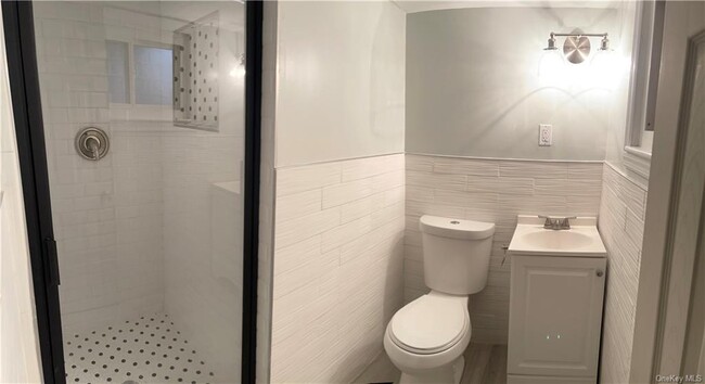
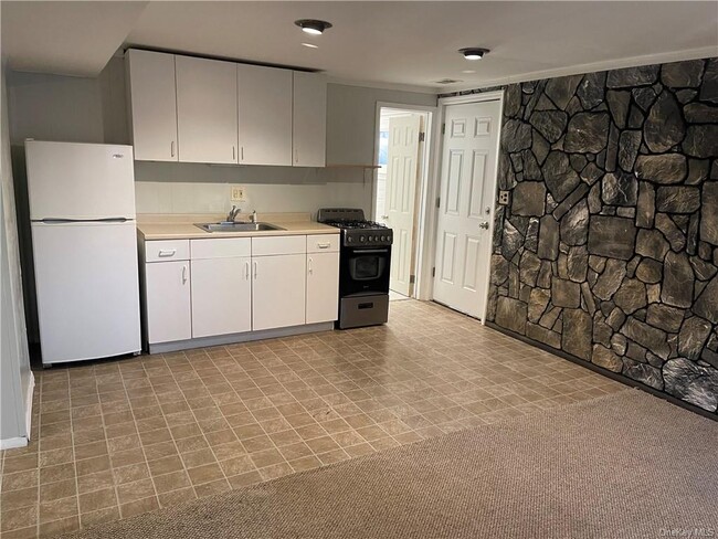
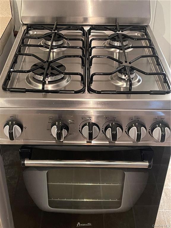
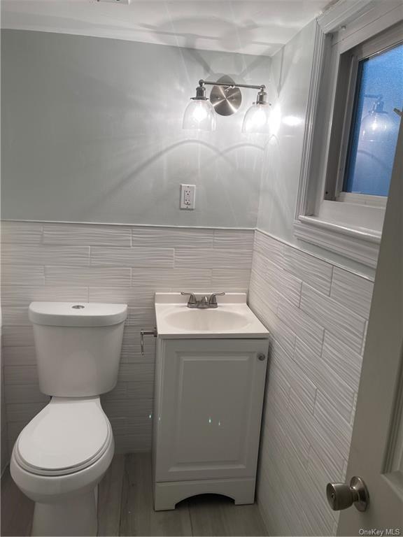
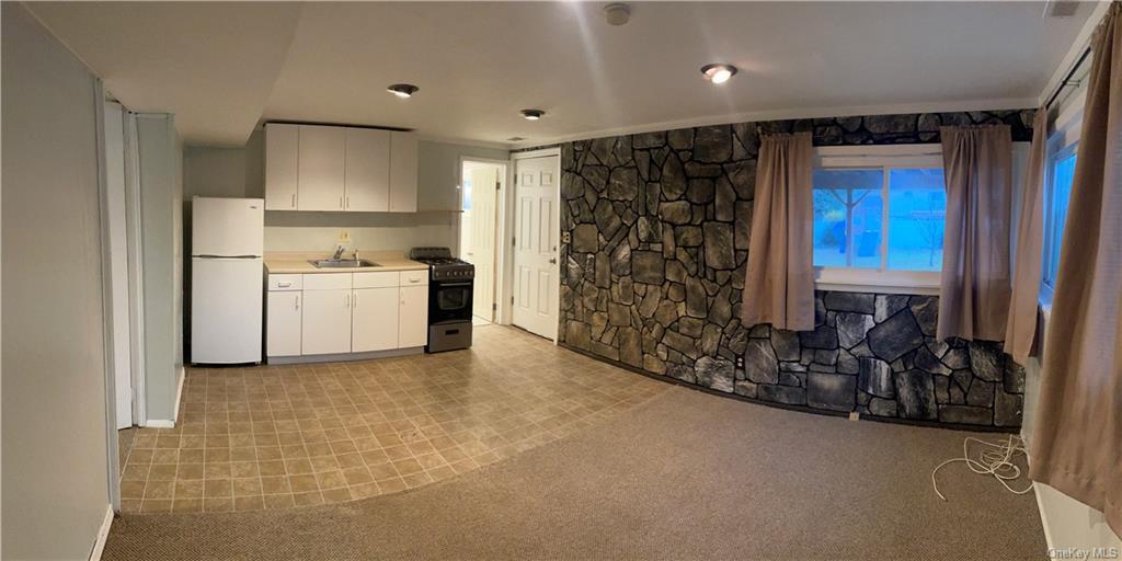
PRIVACY,CHARM w/ PLENTY OF STORAGE!! RIGHT in the HEART of NORTH DEER PARK!! This lovely,warm & cozy,legal accessory 1BR apartment enchants with it's stainless steel gas-stove kitchen. Fully updated bathroom with stand-in rainfall shower. Dining / living room w/ natural stone finish,& direct access to usable patio. Queen-sized bedroom has an easy to organize,spacious closet + an additional large closet. ALL utilities w/ BONUS 1 GB shared Wi-fi,INCLUDED. Convenient to restaurants,shopping,parks,LIRR,highways and beaches! Sorry,no pets. Smoke free property. Verifiable credit and income and history. Based on information submitted to the MLS GRID as of [see last changed date above]. All data is obtained from various sources and may not have been verified by broker or MLS GRID. Supplied Open House Information is subject to change without notice. All information should be independently reviewed and verified for accuracy. Properties may or may not be listed by the office/agent presenting the information. Some IDX listings have been excluded from this website. Prices displayed on all Sold listings are the Last Known Listing Price and may not be the actual selling price.
670 Carlls Path is an apartment community located in Suffolk County and the 11729 ZIP Code.
670 Carlls Path,
Deer Park,
NY
11729
Located about 40 miles east of New York City, Deer Park is a hamlet in the town of Babylon with an abundance of shopping opportunities. Deer Park contains the vast retail haven of Tanger Outlets in addition to a wide variety of shops, restaurants, and small businesses along Deer Park Avenue.
Deer Park’s diverse community is reflected in its broad range of restaurants and eateries, where options like Dominican, Peruvian, Indian, African, and Asian cuisine can all be found within a short distance of one another. Deer Park is convenient to numerous parks, including the popular Belmont Lake State Park. Beaches at Robert Moses State Park and Fire Island National Seashore are just minutes from Deer Park as well as a vibrant nightlife scene in the historic Babylon Village. Getting around from Deer Park is easy with access to the Long Island Rail Road and the Long Island Expressway.
Learn more about living in Deer Park
Education
| Colleges & Universities | Distance | ||
|---|---|---|---|
| Colleges & Universities | Distance | ||
| Drive: | 11 min | 4.4 mi | |
| Drive: | 19 min | 10.3 mi | |
| Drive: | 17 min | 11.9 mi | |
| Drive: | 29 min | 17.3 mi |
670 Carlls Path is within 11 minutes or 4.4 miles from SUNY Suffolk Co., Grant Campus. It is also near Farmingdale State College and Touro University.
Walkability Near 670 Carlls Path Deer Park, NY 11729
Getting Around
 What do Walkability, Transit, Drivability, and Bikeability mean?
Walkability measures the walking distance to day-to-day needs.
Transit measures access to public transportation.
Drivability measures congestion, parking availability, and access to major roads.
Bikeability measures the suitability for cycling.
How It Works
What do Walkability, Transit, Drivability, and Bikeability mean?
Walkability measures the walking distance to day-to-day needs.
Transit measures access to public transportation.
Drivability measures congestion, parking availability, and access to major roads.
Bikeability measures the suitability for cycling.
How It Works
Fairly Walkable
Walkability
50
/ 100
Limited Public Transit
Transit
20
/ 100
Moderately Drivable
Drivability
70
/ 100
Moderately Bikeable
Bikeability
60
/ 100
Scores provided by
-
Soundscore™
-
/ 100
Traffic
-Airport
-Businesses
-Scores provided by
HowLoud What is a Sound Score Rating? A Sound Score Rating aggregates noise caused by vehicle traffic, airplane traffic and local sources. How It WorksYou May Also Like
-
Beacon Harbor Point
1 Harbor Point Rd
Stamford, CT 06902
$3,215 - $5,795 Total Monthly Price
1-2 Br 21.6 mi
-
121 Towne Apartments
121 Towne St
Stamford, CT 06902
$2,400 - $5,000 Total Monthly Price
1-3 Br 21.7 mi
-
The Parc at Glenbrook
66 Glenbrook Rd
Stamford, CT 06902
$2,350 - $3,375 Plus Fees
1-2 Br 12 Month Lease 22.3 mi
Similar Rentals Nearby
-
-
-
-
-
1 Bed$2,974+2 Beds$2,859+3 Beds$5,052+Total Monthly PriceTotal Monthly Price NewPrices include base rent and required monthly fees of $83. Variable costs based on usage may apply.Base Rent:1 Bed$2,890+2 Beds$2,775+3 Beds$4,968+
Pets Allowed Fitness Center Clubhouse
-
-
-
-
1 Bed$3,093+2 Beds$3,593+3 Beds$4,668+Total Monthly Price12 Month LeaseTotal Monthly Price NewPrices include base rent and required monthly fees of $103. Variable costs based on usage may apply.Base Rent:1 Bed$2,900+2 Beds$3,490+3 Beds$4,565+Specials
Pets Allowed Fitness Center Pool Dishwasher Refrigerator In Unit Washer & Dryer Walk-In Closets
-
1 Bed$2,745+2 Beds$4,415+Total Monthly PriceTotal Monthly Price NewPrices include required monthly fees of $100.Base Rent:1 Bed$2,645+2 Beds$4,315+
Fitness Center Pool In Unit Washer & Dryer Package Service Concierge EV Charging


What Are Walk Score®, Transit Score®, and Bike Score® Ratings?
Walk Score® measures the walkability of any address. Transit Score® measures access to public transit. Bike Score® measures the bikeability of any address.
What is a Sound Score Rating?
A Sound Score Rating aggregates noise caused by vehicle traffic, airplane traffic and local sources.
670 Carlls Path
Deer Park, NY 11729