
$699 / Month
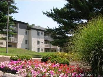
67 Blue Stone Ct
Lakeside Park, KY 41017
2 Weeks Ago
Favorites
67 Blue Stone Ct

Favorites
Check Back Soon for Upcoming Availability
| Beds | Baths | Average SF |
|---|---|---|
| 2 Bedrooms 2 Bedrooms 2 Br | 1 Bath 1 Bath 1 Ba | 990 SF |
About This Property
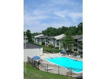
(859) 331-7170 - Nestled quietly in the gently rolling hills of Northern Kentucky, Derby Ridge offers you seclusion with city convenience. Derby Ridge is just minutes from all major interstates, local schools and Crestview Hills Town Center! (RLNE86680) Other Amenities - Parking, Pool. Appliances - Dishwasher, Air Conditioning, Refrigerator, Range, Oven, Garbage Disposal. Lease lengths - 12 Months. Details regarding this property's Utilities - Resident Pays Electricity, Water Included, Trash Pick-up Included. Pet policies - Small Dogs Allowed- up to 35lbs, Cats Allowed- up to 35lbs.
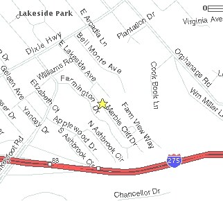
67 Blue Stone Ct is a condo located in Kenton County and the 41017 ZIP Code. This area is served by the Kenton County attendance zone.
Condo Features
- Air Conditioning
Location
Get Directions
Northern Kentucky is a sprawling region located just south of Cincinnati, Ohio. The Ohio River hugs the northern, eastern, and western portions of the region, serving as a scenic destination for all kinds of outdoor recreation throughout the year. Florence, Dayton, Newport, Covington, Burlington, and Highland Heights are among the many communities included in the Northern Kentucky region.
Each community in Northern Kentucky offers its own unique identity and sense of character. The rentals in the area are just as diverse as Northern Kentucky itself, ranging from luxury apartments to charming houses and everything in between. Getting around the region is a breeze with convenience to Interstates 71, 75, 275, and 471.
Learn more about living in Northern KentuckyBelow are rent ranges for similar nearby apartments
Amenities
- Air Conditioning
Education
| Colleges & Universities | Distance | ||
|---|---|---|---|
| Colleges & Universities | Distance | ||
| Drive: | 5 min | 1.8 mi | |
| Drive: | 14 min | 8.6 mi | |
| Drive: | 19 min | 10.8 mi | |
| Drive: | 26 min | 13.8 mi |
67 Blue Stone Ct is within 5 minutes or 1.8 miles from Thomas More College. It is also near Northern Kentucky University and College of Mount St. Joseph.
Schools


Public Elementary School
Grades PK-5
931 Students
Attendance Zone
Public Middle School
Grades 6-8
1,029 Students
Attendance Zone
Public High School
Grades 9-12
1,561 Students
Attendance Zone
Private Elementary School
Grades PK-5
92 Students
Nearby
Private Elementary, Middle & High School
Grades K-12
Nearby
School data provided by
 The GreatSchools Rating helps parents compare schools within a state based on a variety of school quality indicators and provides a helpful picture of how effectively each school serves all of its students. Ratings are on a scale of 1 (below average) to 10 (above average) and can include test scores, college readiness, academic progress, advanced courses, equity, discipline and attendance data. We also advise parents to visit schools, consider other information on school performance and programs, and consider family needs as part of the school selection process.
View GreatSchools Rating Methodology
Data provided by GreatSchools.org © 2025. All rights reserved.
View GreatSchools Rating Methodology
Data provided by GreatSchools.org © 2025. All rights reserved.
Transportation options available in Lakeside Park include The Banks Station, 2Nd & Main, located 6.7 miles from 67 Blue Stone Ct. 67 Blue Stone Ct is near Cincinnati/Northern Kentucky International, located 7.3 miles or 19 minutes away.
| Transit / Subway | Distance | ||
|---|---|---|---|
| Transit / Subway | Distance | ||
| Drive: | 12 min | 6.7 mi | |
| Drive: | 13 min | 6.8 mi | |
| Drive: | 13 min | 6.9 mi | |
| Drive: | 13 min | 7.0 mi | |
| Drive: | 13 min | 7.0 mi |
| Commuter Rail | Distance | ||
|---|---|---|---|
| Commuter Rail | Distance | ||
|
|
Drive: | 15 min | 7.7 mi |
| Airports | Distance | ||
|---|---|---|---|
| Airports | Distance | ||
|
Cincinnati/Northern Kentucky International
|
Drive: | 19 min | 7.3 mi |
Time and distance from 67 Blue Stone Ct.
| Shopping Centers | Distance | ||
|---|---|---|---|
| Shopping Centers | Distance | ||
| Walk: | 16 min | 0.9 mi | |
| Drive: | 4 min | 1.5 mi | |
| Drive: | 4 min | 1.5 mi |
67 Blue Stone Ct has 3 shopping centers within 1.5 miles, which is about a 4-minute walk. The miles and minutes will be for the farthest away property.
| Parks and Recreation | Distance | ||
|---|---|---|---|
| Parks and Recreation | Distance | ||
|
John G. & Phyllis W. Smale Riverfront Park
|
Drive: | 12 min | 6.7 mi |
|
Newport Aquarium
|
Drive: | 16 min | 7.9 mi |
|
Wilson Commons
|
Drive: | 16 min | 8.9 mi |
|
Imago Earth Center
|
Drive: | 18 min | 10.1 mi |
|
Embshoff Woods
|
Drive: | 22 min | 11.6 mi |
67 Blue Stone Ct has 5 parks within 11.6 miles, including John G. & Phyllis W. Smale Riverfront Park, Newport Aquarium, and Wilson Commons.
| Hospitals | Distance | ||
|---|---|---|---|
| Hospitals | Distance | ||
| Drive: | 6 min | 2.6 mi | |
| Drive: | 8 min | 3.6 mi | |
| Drive: | 9 min | 4.7 mi |
67 Blue Stone Ct has 3 hospitals within 4.7 miles, the nearest is St. Elizabeth Edgewood which is 2.6 miles away and a 6 minute drive.
| Military Bases | Distance | ||
|---|---|---|---|
| Military Bases | Distance | ||
| Drive: | 81 min | 61.2 mi | |
| Drive: | 87 min | 66.3 mi | |
| Drive: | 90 min | 69.6 mi |
67 Blue Stone Ct has 3 military bases within 69.6 miles, the nearest is Gentile Air Force Station which is 61.2 miles away and a 81 minute drive.
You May Also Like
Similar Rentals Nearby
-
-

-

-

-

-

-

-
 $2,5955 Beds, 1.5 Baths, 1,700 sq ftApartment for Rent
 -
 $1,6004 Beds, 1 Bath, 1,300 sq ftApartment for Rent
 -
 $1,6004 Beds, 2 Baths, 1,400 sq ftApartment for Rent
What Are Walk Score®, Transit Score®, and Bike Score® Ratings?
Walk Score® measures the walkability of any address. Transit Score® measures access to public transit. Bike Score® measures the bikeability of any address.
What is a Sound Score Rating?
A Sound Score Rating aggregates noise caused by vehicle traffic, airplane traffic and local sources

67 Blue Stone Ct
Lakeside Park, KY 41017