


$5,200
/ Month
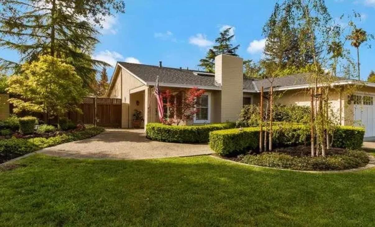
669 Rock Island Cir
Danville, CA 94526
Today
|
Edit
Favorites
925-963-1767
-
Bedrooms
3
-
Bathrooms
2
-
Square Feet
1,651 sq ft
-
Available
Available Now
Highlights
- Engineered Wood Flooring
- Solid Surface Countertops
- Community Pool
- Tennis Courts
- Cul-De-Sac
- Plantation Shutters
669 Rock Island Cir

Favorites
About This Home
Available Now
Great Greenbrook Home in Prime Court Location! Large Lot offers peaceful outdoor space. Open floorplan,wood floors,crown moulding and plantation shutters. Updated kitchen with stone counters,SS appliances including gas range,island and breakfast bar. Remodeled baths plus skylights and fireplace. French doors to private yard with patio,mature landscaping,deck and multi-use shed. Landscaping maintenance and access to Greenbrook Pool,Tennis Courts and Greenbelt are included. 1 year lease. No Pets. No smoking. Two car limit. Security deposit equal to one month's rent. Must have 700+ credit score. Tenant will provide evidence of renters insurance. Apply with RentSpree
669 Rock Island Cir is a house located in Contra Costa County and the 94526 ZIP Code. This area is served by the San Ramon Valley Unified attendance zone.
* Price shown is base rent. Excludes user-selected optional fees and variable or usage-based fees and required charges due at or prior to move-in or at move-out. Price, availability, fees, and any applicable rent special are subject to change without notice.
* Square footage definitions vary. Displayed square footage is approximate.
Home Details
Home Type
Single Family Detached Home
Year Built
Built in 1976
Bedrooms and Bathrooms
2 Full Bathrooms
3 Bedrooms
Flooring
Engineered Wood
Tile
Carpet
Home Design
Composition Shingle Roof
Stucco
Interior Spaces
Living Room with Fireplace
Plantation Shutters
Double Pane Windows
Crown Molding
1-Story Property
Kitchen
Solid Surface Countertops
Breakfast Bar
Gas Range
Microwave
Dishwasher
Plumbed For Ice Maker
Laundry
Washer and Dryer Hookup
Listing and Financial Details
Assessor Parcel Number 2184620256
Lot Details
8,960 Sq Ft Lot
Cul-De-Sac
Back and Front Yard
Parking
2 Car Attached Garage
Garage Door Opener
Utilities
Forced Air Heating and Cooling System
Community Details
Overview
Greenbelt
Property has a Home Owners Association
Greenbrook HOA
Greenbrook Subdivision
Association fees include common area maintenance
Pet Policy
No Pets Allowed
Recreation
Community Pool
Tennis Courts
Contact
- Listed by Josh Hanna | Investment Real Estate
- Phone Number
- Contact
-
Source
 Bay East Association of REALTORS ®
Copyright© 2026 Bay East, Contra Costa, bridgeMLS. All rights reserved. All information provided by the listing agent/broker is deemed reliable but is not guaranteed and should be independently verified.
Location
Get Directions
Danville is an upscale suburban community located just south of Walnut Creek and about twenty miles east of Oakland. Residents enjoy an ideal location, surrounded by scenic rolling hills and lush greenery while still being within minutes of the Bay Area’s biggest cities. The thriving Downtown district along Hartz Boulevard is packed with terrific restaurants, specialty shops, and bars, as well as unique attractions like the Village Theatre and Art Gallery and the Danville Farmers’ Market. The surrounding landscape offers terrific opportunities to make the most of California’s natural beauty, with Las Trampas Regional Wilderness and the Diablo Foothills just outside of town providing great venues for hiking and camping.
Learn more about living in Danville
Education
| Colleges & Universities | Distance | ||
|---|---|---|---|
| Colleges & Universities | Distance | ||
| Drive: | 16 min | 7.4 mi | |
| Drive: | 29 min | 14.8 mi | |
| Drive: | 27 min | 15.0 mi | |
| Drive: | 25 min | 16.1 mi |
669 Rock Island Cir is within 16 minutes or 7.4 miles from Diablo Valley Coll, San Ramon. It is also near Saint Marys Coll. of Calif. and Cal State East Bay.
Schools


Public Elementary School
Grades K-5
437 Students
Attendance Zone
Public Elementary School
Grades K-5
497 Students
Nearby
Public Middle School
Grades 6-8
878 Students
Attendance Zone
Public High School
Grades 9-12
1,981 Students
Attendance Zone
Private Elementary School
Grades K-3
12 Students
Nearby
Private Elementary & Middle School
Grades PK-8
Nearby
Private Elementary & Middle School
Grades K-8
355 Students
Nearby
School data provided by
 The GreatSchools Rating helps parents compare schools within a state based on a variety of school quality indicators and provides a helpful picture of how effectively each school serves all of its students. Ratings are on a scale of 1 (below average) to 10 (above average) and can include test scores, college readiness, academic progress, advanced courses, equity, discipline and attendance data. We also advise parents to visit schools, consider other information on school performance and programs, and consider family needs as part of the school selection process.
View GreatSchools Rating Methodology
Data provided by GreatSchools.org © 2026. All rights reserved.
View GreatSchools Rating Methodology
Data provided by GreatSchools.org © 2026. All rights reserved.
Transportation options available in Danville include West Dublin/Pleasanton Station, located 8.3 miles from 669 Rock Island Cir. 669 Rock Island Cir is near Metro Oakland International, located 21.8 miles or 35 minutes away, and San Francisco International, located 35.7 miles or 54 minutes away.
| Transit / Subway | Distance | ||
|---|---|---|---|
| Transit / Subway | Distance | ||
|
|
Drive: | 12 min | 8.3 mi |
|
|
Drive: | 14 min | 9.4 mi |
|
|
Drive: | 16 min | 10.4 mi |
|
|
Drive: | 24 min | 13.4 mi |
| Commuter Rail | Distance | ||
|---|---|---|---|
| Commuter Rail | Distance | ||
| Drive: | 18 min | 12.7 mi | |
| Drive: | 19 min | 12.8 mi | |
|
|
Drive: | 26 min | 13.6 mi |
| Drive: | 26 min | 13.6 mi | |
| Drive: | 26 min | 17.5 mi |
| Airports | Distance | ||
|---|---|---|---|
| Airports | Distance | ||
|
Metro Oakland International
|
Drive: | 35 min | 21.8 mi |
|
San Francisco International
|
Drive: | 54 min | 35.7 mi |
Time and distance from 669 Rock Island Cir.
| Shopping Centers | Distance | ||
|---|---|---|---|
| Shopping Centers | Distance | ||
| Drive: | 4 min | 1.6 mi | |
| Drive: | 4 min | 1.7 mi | |
| Drive: | 5 min | 2.0 mi |
669 Rock Island Cir has 3 shopping centers within 2.0 miles, which is about a 5-minute drive. The miles and minutes will be for the farthest away property.
| Parks and Recreation | Distance | ||
|---|---|---|---|
| Parks and Recreation | Distance | ||
|
Bishop Ranch Regional Preserve
|
Drive: | 9 min | 4.4 mi |
|
Eugene O'Neill National Historic Site
|
Drive: | 13 min | 5.2 mi |
|
Little Hills Picnic Ranch (By Reservation)
|
Drive: | 21 min | 6.5 mi |
|
Las Trampas Regional Wilderness
|
Drive: | 22 min | 6.9 mi |
|
Mount Diablo State Park
|
Drive: | 39 min | 12.9 mi |
669 Rock Island Cir has 5 parks within 12.9 miles, including Bishop Ranch Regional Preserve, Eugene O'Neill National Historic Site, and Las Trampas Regional Wilderness.
| Hospitals | Distance | ||
|---|---|---|---|
| Hospitals | Distance | ||
| Drive: | 7 min | 2.6 mi | |
| Drive: | 13 min | 8.8 mi | |
| Drive: | 18 min | 11.6 mi |
669 Rock Island Cir has 3 hospitals within 11.6 miles, the nearest is San Ramon Regional Medical Center which is 2.6 miles away and a 7 minute drive.
You May Also Like
Similar Rentals Nearby


What Are Walk Score®, Transit Score®, and Bike Score® Ratings?
Walk Score® measures the walkability of any address. Transit Score® measures access to public transit. Bike Score® measures the bikeability of any address.
What is a Sound Score Rating?
A Sound Score Rating aggregates noise caused by vehicle traffic, airplane traffic and local sources
669 Rock Island Cir
Danville, CA 94526