

$3,200
/ Month
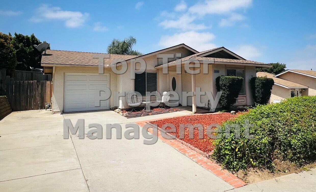
663 Cedar St
San Marcos, CA 92069
2 Weeks Ago
|
Edit
Favorites
663 Cedar St

Favorites
Check Back Soon for Upcoming Availability
| Beds | Baths | Average SF |
|---|---|---|
| 2 Bedrooms 2 Bedrooms 2 Br | 2 Baths 2 Baths 2 Ba | 930 SF |
About This Property
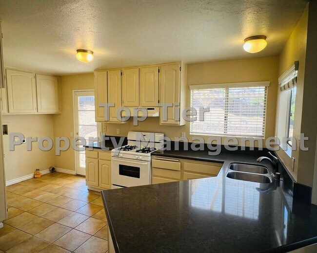
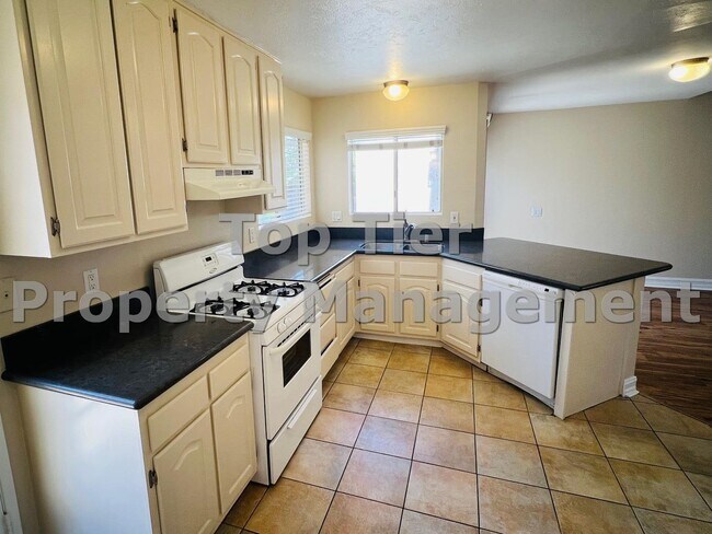
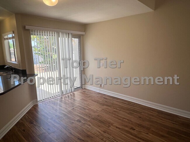
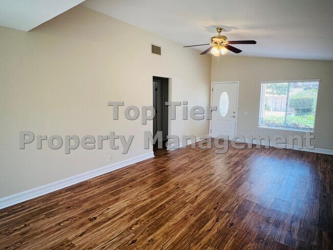
-Washer/dryer hook-ups -Central AC/heat -Pets negotiable with additional security deposit -Attached 1-car garage and driveway parking -2 outdoor storage sheds -Tenant responsible for all utilities -Gardener included. Beautiful 2 bedroom, 2 bath detached home (NOT condo or townhome) with 1 car garage (2 car driveway) and a huge yard. Located on a peaceful cul-de-sac and convenient to Palomar college, UCSM, city hall, library, etc. Indoor laundry area. Just a few steps to open space rustic park with walking trails. LARGE private back yard with nice patio, a shed for storage and a small play house. Freshly painted inside, newer luxury vinyl plank flooring, remodeled kitchen with newer quartz countertops and breakfast bar.
663 Cedar St is a house located in San Diego County and the 92069 ZIP Code. This area is served by the San Marcos Unified attendance zone.
Location
Get Directions
San Marcos, located in North County San Diego, combines suburban living with educational opportunities. Home to California State University San Marcos and Palomar College, the city maintains a welcoming community atmosphere while serving as an educational center. The rental market includes apartments near the university district and residential communities in San Elijo Hills and Discovery Hills. Current rental trends show average prices of $2,324 for one-bedroom units and $2,707 for two-bedrooms, with slight adjustments occurring across different unit sizes in the past year.
Notable landmarks include Lake San Marcos and its hillside cross, which illuminates the evening skyline. Walnut Grove Park features the historic Williams Barn, offering a glimpse into the area's agricultural past. The developing Creek District and University District complement established areas like Twin Oaks Valley, known for its hiking trails and open spaces.
Learn more about living in San Marcos
Education
| Colleges & Universities | Distance | ||
|---|---|---|---|
| Colleges & Universities | Distance | ||
| Walk: | 16 min | 0.9 mi | |
| Drive: | 5 min | 2.4 mi | |
| Drive: | 7 min | 2.6 mi | |
| Drive: | 16 min | 11.3 mi |
663 Cedar St is within 16 minutes or 0.9 mile from USAHS. It is also near Palomar College and CSU San Marcos.
Schools


Public Elementary, Middle & High School
Grades K-12
59 Students
Nearby
Public Elementary School
Grades K-5
823 Students
Attendance Zone
Public Middle School
Grades 6-8
1,183 Students
Attendance Zone
Public High School
Grades 9-12
2,893 Students
Attendance Zone
Private Elementary, Middle & High School
Grades 1-12
Nearby
Private Elementary & Middle School
Grades PK-8
Nearby
Private Elementary School
Grades K-3
Nearby
School data provided by
 The GreatSchools Rating helps parents compare schools within a state based on a variety of school quality indicators and provides a helpful picture of how effectively each school serves all of its students. Ratings are on a scale of 1 (below average) to 10 (above average) and can include test scores, college readiness, academic progress, advanced courses, equity, discipline and attendance data. We also advise parents to visit schools, consider other information on school performance and programs, and consider family needs as part of the school selection process.
View GreatSchools Rating Methodology
Data provided by GreatSchools.org © 2026. All rights reserved.
View GreatSchools Rating Methodology
Data provided by GreatSchools.org © 2026. All rights reserved.
Transportation options available in San Marcos include San Marcos Civic Center, located 1.3 miles from 663 Cedar St. 663 Cedar St is near San Diego International, located 34.5 miles or 46 minutes away.
| Transit / Subway | Distance | ||
|---|---|---|---|
| Transit / Subway | Distance | ||
|
|
Drive: | 3 min | 1.3 mi |
|
|
Drive: | 4 min | 2.3 mi |
|
|
Drive: | 5 min | 2.4 mi |
|
|
Drive: | 5 min | 2.6 mi |
|
|
Drive: | 8 min | 4.8 mi |
| Commuter Rail | Distance | ||
|---|---|---|---|
| Commuter Rail | Distance | ||
|
|
Drive: | 21 min | 12.0 mi |
|
|
Drive: | 24 min | 13.5 mi |
|
|
Drive: | 22 min | 15.5 mi |
|
|
Drive: | 24 min | 17.2 mi |
|
|
Drive: | 30 min | 18.3 mi |
| Airports | Distance | ||
|---|---|---|---|
| Airports | Distance | ||
|
San Diego International
|
Drive: | 46 min | 34.5 mi |
Time and distance from 663 Cedar St.
| Shopping Centers | Distance | ||
|---|---|---|---|
| Shopping Centers | Distance | ||
| Walk: | 18 min | 1.0 mi | |
| Walk: | 19 min | 1.0 mi | |
| Drive: | 3 min | 1.1 mi |
663 Cedar St has 3 shopping centers within 1.1 miles, which is about a 3-minute drive. The miles and minutes will be for the farthest away property.
| Parks and Recreation | Distance | ||
|---|---|---|---|
| Parks and Recreation | Distance | ||
|
Palomar College Arboretum
|
Drive: | 4 min | 2.3 mi |
|
Del Dios Preserve
|
Drive: | 14 min | 6.9 mi |
|
Felicita County Park
|
Drive: | 14 min | 7.6 mi |
|
Kit Carson Park
|
Drive: | 16 min | 10.0 mi |
|
Queen Califia's Magical Circle
|
Drive: | 16 min | 10.0 mi |
663 Cedar St has 5 parks within 10.0 miles, including Palomar College Arboretum, Del Dios Preserve, and Felicita County Park.
| Hospitals | Distance | ||
|---|---|---|---|
| Hospitals | Distance | ||
| Drive: | 11 min | 6.3 mi | |
| Drive: | 14 min | 10.7 mi |
663 Cedar St is 6.3 miles from Palomar Health Downtown Campus, and is convenient to other hospitals, including Tri - City Medical Center.
| Military Bases | Distance | ||
|---|---|---|---|
| Military Bases | Distance | ||
| Drive: | 35 min | 21.6 mi | |
| Drive: | 44 min | 30.9 mi |
663 Cedar St is 21.6 miles from USMC Air Station Miramar, and is convenient to other military bases, including Marine Corps Base Camp Pendleton.
You May Also Like
Similar Rentals Nearby


What Are Walk Score®, Transit Score®, and Bike Score® Ratings?
Walk Score® measures the walkability of any address. Transit Score® measures access to public transit. Bike Score® measures the bikeability of any address.
What is a Sound Score Rating?
A Sound Score Rating aggregates noise caused by vehicle traffic, airplane traffic and local sources
663 Cedar St
San Marcos, CA 92069