

$3,500
/ Month
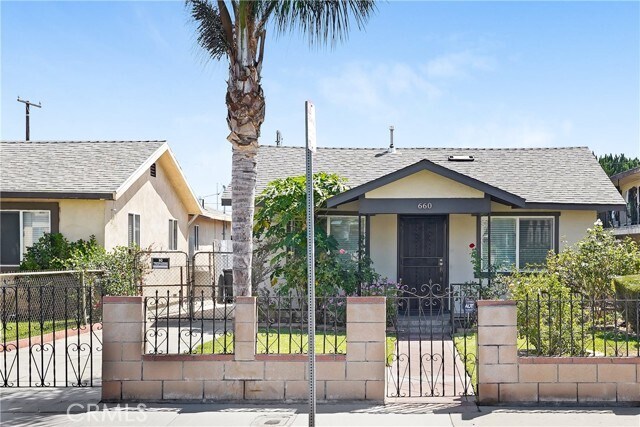
660 S La Verne Ave
East Los Angeles, CA 90022
Today
Favorites
562-445-7375
-
Bedrooms
3
-
Bathrooms
1
-
Square Feet
1,000 sq ft
-
Available
Available Sep 11
660 S La Verne Ave

Favorites
About This Home
$3,500 deposit,
Available Sep 11
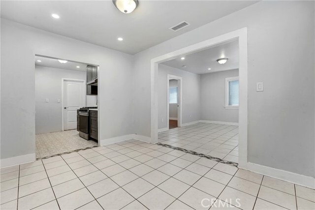
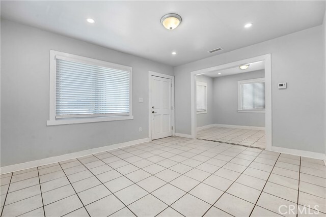
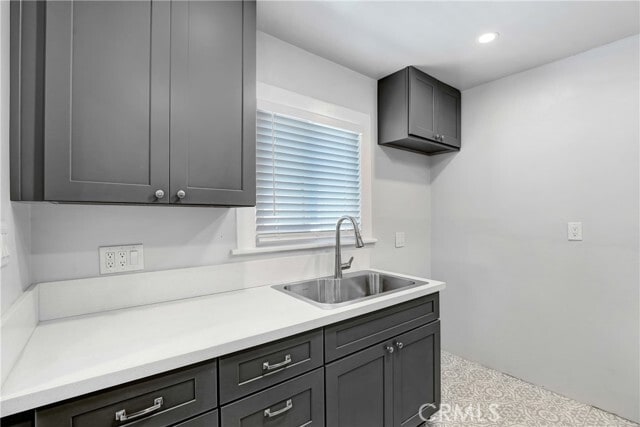
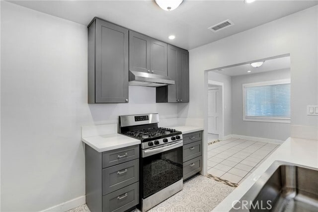
For Lease – East Los Angeles A beautiful and tranquil home is now available for lease! 3 Bedrooms / 1 Bathroom Completely remodeled interior Brand new stove Washer & dryer hookups 1 parking space included Just 15 minutes from Downtown Los Angeles Close to James A. Garfield High School Features: Wood and tile flooring throughout Front yard with fence, papaya tree, colorful flowers, and lush green grass with sprinklers Spacious backyard with lemon, persimmon, cactus, and other fruit trees—perfect for relaxing and enjoying nature This home combines comfort, convenience, and charm in a great location. MLS# DW25207665
660 S La Verne Ave is a house located in Los Angeles County and the 90022 ZIP Code. This area is served by the Los Angeles Unified attendance zone.
* Price shown is base rent and may not include non-optional fees and utilities. Price, availability, fees, and any applicable rent special are subject to change without notice.
* Square footage definitions vary. Displayed square footage is approximate.
House Features
Air Conditioning
Heating
Range
Dining Room
- Air Conditioning
- Heating
- Range
- Dining Room
Fees and Policies
The fees below are based on community-supplied data and may exclude additional fees and utilities.
Contact
- Listed by Amparo Gastelum | Max Real Estate
- Phone Number
- Contact
-
Source
 California Regional Multiple Listing Service
Copyright 2025 © California Regional MLS. All rights reserved.
Location
Get Directions
Amenities
- Air Conditioning
- Heating
- Range
- Dining Room
Southeast Los Angeles is directly south of the Fashion District and east of the University of Southern California (USC). This large neighborhood is minutes from downtown Los Angeles, Hollywood, and Beverly Hills, with easy access to the 110 Freeway. This great location places you near sunny beaches, nature trails, and a bevy of leading employers. Students can access both USC and California State University Long Beach from their Southeast LA apartment.
This densely populated, diverse neighborhood features everything from food trucks and corner markets to wide sidewalks and residential areas filled with bungalows, ranch, and Spanish Colonial architecture. Southeast LA features palm trees and mountain views, tampered with gritty undertones to give it a cool, funky vibe.
As for outdoor fun, take your pick between Catalina Island, Venus Beach, or the Santa Monica Pier. Nearby, you’ll find more sunny beaches like White Point, Cabrillo, and Long Beach.
Learn more about living in Southeast Los Angeles
Education
| Colleges & Universities | Distance | ||
|---|---|---|---|
| Colleges & Universities | Distance | ||
| Drive: | 4 min | 1.8 mi | |
| Drive: | 9 min | 4.0 mi | |
| Drive: | 12 min | 5.8 mi | |
| Drive: | 13 min | 6.6 mi |
660 S La Verne Ave is within 4 minutes or 1.8 miles from East Los Angeles College. It is also near Cal State Los Angeles and USC, Health Sciences Campus.
Schools


Public Elementary School
Grades K-1
182 Students
Attendance Zone
Public Elementary School
Grades 2-5
295 Students
Attendance Zone
Charter Elementary School
Grades K-5
75 Students
Nearby
Public Middle School
Grades 6-8
1,189 Students
Attendance Zone
Public High School
Grades 9-12
2,247 Students
Attendance Zone
Public High School
Grades 9-12
218 Students
Attendance Zone
Private Elementary & Middle School
Grades K-8
118 Students
Nearby
Private Elementary, Middle & High School
Grades K-12
15 Students
Nearby
Private Elementary & Middle School
Grades PK-8
245 Students
Nearby
School data provided by
 The GreatSchools Rating helps parents compare schools within a state based on a variety of school quality indicators and provides a helpful picture of how effectively each school serves all of its students. Ratings are on a scale of 1 (below average) to 10 (above average) and can include test scores, college readiness, academic progress, advanced courses, equity, discipline and attendance data. We also advise parents to visit schools, consider other information on school performance and programs, and consider family needs as part of the school selection process.
View GreatSchools Rating Methodology
Data provided by GreatSchools.org © 2025. All rights reserved.
View GreatSchools Rating Methodology
Data provided by GreatSchools.org © 2025. All rights reserved.
Transportation options available in East Los Angeles include East La Civic Center, located 0.8 mile from 660 S La Verne Ave. 660 S La Verne Ave is near Long Beach (Daugherty Field), located 17.8 miles or 28 minutes away, and Los Angeles International, located 23.9 miles or 33 minutes away.
| Transit / Subway | Distance | ||
|---|---|---|---|
| Transit / Subway | Distance | ||
|
|
Walk: | 15 min | 0.8 mi |
| Walk: | 18 min | 1.0 mi | |
|
|
Drive: | 3 min | 1.2 mi |
|
|
Drive: | 6 min | 2.4 mi |
|
|
Drive: | 8 min | 3.7 mi |
| Commuter Rail | Distance | ||
|---|---|---|---|
| Commuter Rail | Distance | ||
|
|
Drive: | 7 min | 3.0 mi |
|
|
Drive: | 9 min | 3.7 mi |
|
|
Drive: | 11 min | 6.4 mi |
|
|
Drive: | 13 min | 6.5 mi |
| Drive: | 14 min | 10.3 mi |
| Airports | Distance | ||
|---|---|---|---|
| Airports | Distance | ||
|
Long Beach (Daugherty Field)
|
Drive: | 28 min | 17.8 mi |
|
Los Angeles International
|
Drive: | 33 min | 23.9 mi |
Time and distance from 660 S La Verne Ave.
| Shopping Centers | Distance | ||
|---|---|---|---|
| Shopping Centers | Distance | ||
| Walk: | 11 min | 0.6 mi | |
| Walk: | 12 min | 0.7 mi | |
| Walk: | 13 min | 0.7 mi |
660 S La Verne Ave has 3 shopping centers within 0.7 mile, which is about a 13-minute walk. The miles and minutes will be for the farthest away property.
| Parks and Recreation | Distance | ||
|---|---|---|---|
| Parks and Recreation | Distance | ||
|
Hollenbeck Lake
|
Drive: | 8 min | 5.0 mi |
|
Pio Pico State Historic Park
|
Drive: | 14 min | 6.6 mi |
|
Whittier Narrows Recreation Area
|
Drive: | 13 min | 7.2 mi |
|
Augustus Hawkins Natural Park
|
Drive: | 14 min | 8.0 mi |
|
Audubon Center at Debs Park
|
Drive: | 15 min | 9.3 mi |
660 S La Verne Ave has 5 parks within 9.3 miles, including Hollenbeck Lake, Pio Pico State Historic Park, and Augustus Hawkins Natural Park.
| Hospitals | Distance | ||
|---|---|---|---|
| Hospitals | Distance | ||
| Drive: | 4 min | 1.5 mi | |
| Drive: | 4 min | 1.8 mi | |
| Drive: | 6 min | 2.5 mi |
660 S La Verne Ave has 3 hospitals within 2.5 miles, the nearest is East Los Angeles Doctors Hospital which is 1.5 miles away and a 4 minute drive.
| Military Bases | Distance | ||
|---|---|---|---|
| Military Bases | Distance | ||
| Drive: | 31 min | 20.4 mi | |
| Drive: | 30 min | 22.2 mi |
660 S La Verne Ave is 20.4 miles from Los Alamitos Army Airfield, and is convenient to other military bases, including Los Angeles Air Force Base.
You May Also Like
Similar Rentals Nearby


What Are Walk Score®, Transit Score®, and Bike Score® Ratings?
Walk Score® measures the walkability of any address. Transit Score® measures access to public transit. Bike Score® measures the bikeability of any address.
What is a Sound Score Rating?
A Sound Score Rating aggregates noise caused by vehicle traffic, airplane traffic and local sources
660 S La Verne Ave
East Los Angeles, CA 90022