

$927
/ Month
660 Greg Thatch Cir Unit Up 2
Sacramento, CA 95835
Today
|
Edit
Favorites
916-232-7829
-
Bedrooms
1
-
Bathrooms
3
-
Square Feet
--
-
Available
Available Now
660 Greg Thatch Cir Unit Up 2

Favorites
About This Home
Available Now
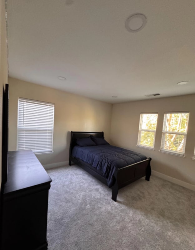
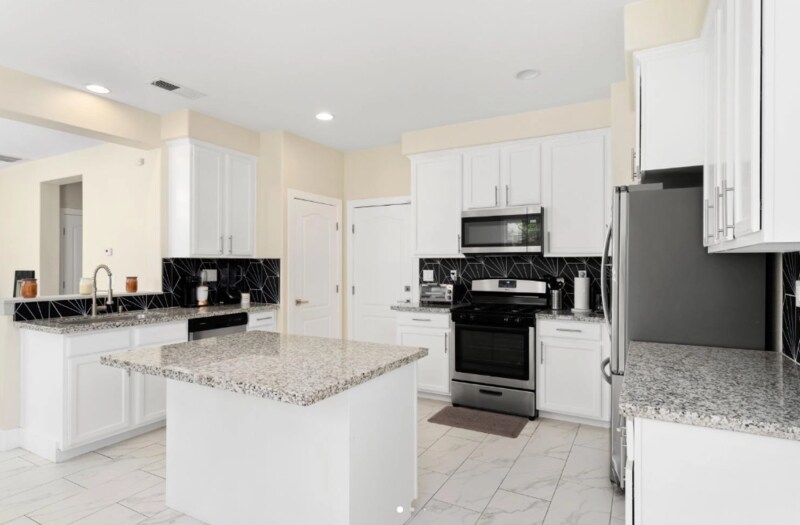
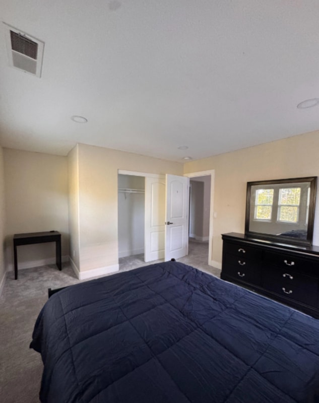
Looking for a bright and comfortable space to call home? This inviting room for rent at 660 Greg Thatch Circle in Sacramento offers the perfect blend of privacy and convenience. With tall ceilings and large windows that let in plenty of natural light, the room feels open and refreshing, a peaceful place to relax, study, or unwind after a long day. Located just steps away from a shared full bathroom and a full size laundry room, this room provides easy access to all the essentials. You’ll also enjoy shared use of the home’s kitchen, dining area, and living room, all fully furnished and well maintained for your comfort. It’s a great setup for anyone seeking an easygoing and community friendly living environment while still enjoying personal space. Nestled in a quiet, desirable Sacramento neighborhood, this home is close to shopping centers, restaurants, parks, and major routes for a simple daily commute. Whether you are a student, young professional, or someone looking for a bright, spacious room in a convenient location, this spot at 660 Greg Thatch Circle offers an excellent balance of comfort, accessibility, and value.
660 Greg Thatch Cir is a condo located in Sacramento County and the 95835 ZIP Code.
* Price shown is base rent. Excludes user-selected optional fees and variable or usage-based fees and required charges due at or prior to move-in or at move-out. Price, availability, fees, and any applicable rent special are subject to change without notice.
* Square footage definitions vary. Displayed square footage is approximate.
Fees and Policies
The fees below are based on community-supplied data and may exclude additional fees and utilities.
- Dogs
- Allowed
- Cats
- Allowed
Property Fee Disclaimer: Based on community-supplied data and independent market research. Subject to change without notice. May exclude fees for mandatory or optional services and usage-based utilities.
Contact
- Phone Number
- Contact
Location
Get Directions
Surrounded by farmland on nearly three sides, the Natomas Creek neighborhood of Sacramento provides the perfect mix of city and country living. Several neighborhood parks give Natomas Creek its slightly rural feel. Drive roughly three miles south and enjoy the even larger 47-acre North Natomas Regional Park and its freshwater lake.
State Route 99 borders the western edge of the neighborhood, and I-5, which runs past the southwest corner of Natomas Creek, leads to Sacramento International Airport and downtown Sacramento. Most nearby restaurants line up near Del Paso Road, about a three-mile drive. Local favorites include the ultra-modern Tuk Tuk Restaurant, serving Thai fare. Diners wanting to kick things up a notch find that the lively Pete's Restaurant and Brewhouse fits the bill for happy hour drinks and late-night grub.
Learn more about living in Natomas Creek
Education
| Colleges & Universities | Distance | ||
|---|---|---|---|
| Colleges & Universities | Distance | ||
| Drive: | 20 min | 13.0 mi | |
| Drive: | 23 min | 13.1 mi | |
| Drive: | 24 min | 14.1 mi | |
| Drive: | 30 min | 21.3 mi |
660 Greg Thatch Cir Unit Up 2 is within 20 minutes or 13.0 miles from Sacramento City College. It is also near Sacramento State and American River College.
Transportation options available in Sacramento include Township 9 Station (Wb), located 7.8 miles from 660 Greg Thatch Cir Unit Up 2. 660 Greg Thatch Cir Unit Up 2 is near Sacramento International, located 7.0 miles or 12 minutes away.
| Transit / Subway | Distance | ||
|---|---|---|---|
| Transit / Subway | Distance | ||
| Drive: | 12 min | 7.8 mi | |
| Drive: | 12 min | 7.8 mi | |
|
|
Drive: | 13 min | 8.5 mi |
|
|
Drive: | 15 min | 9.3 mi |
|
|
Drive: | 14 min | 9.4 mi |
| Commuter Rail | Distance | ||
|---|---|---|---|
| Commuter Rail | Distance | ||
| Drive: | 13 min | 8.5 mi | |
|
|
Drive: | 30 min | 17.2 mi |
|
|
Drive: | 26 min | 19.4 mi |
|
|
Drive: | 33 min | 21.8 mi |
|
|
Drive: | 47 min | 34.0 mi |
| Airports | Distance | ||
|---|---|---|---|
| Airports | Distance | ||
|
Sacramento International
|
Drive: | 12 min | 7.0 mi |
Time and distance from 660 Greg Thatch Cir Unit Up 2.
| Shopping Centers | Distance | ||
|---|---|---|---|
| Shopping Centers | Distance | ||
| Drive: | 5 min | 2.1 mi | |
| Drive: | 5 min | 2.3 mi | |
| Drive: | 5 min | 2.4 mi |
660 Greg Thatch Cir Unit Up 2 has 3 shopping centers within 2.4 miles, which is about a 5-minute drive. The miles and minutes will be for the farthest away property.
| Parks and Recreation | Distance | ||
|---|---|---|---|
| Parks and Recreation | Distance | ||
|
Natomas Oaks Park
|
Drive: | 11 min | 7.0 mi |
|
Discovery County Park
|
Drive: | 11 min | 7.2 mi |
|
Bannon Creek Parkway
|
Drive: | 12 min | 7.7 mi |
|
California State Railroad Museum
|
Drive: | 13 min | 8.4 mi |
|
Old Sacramento Historic District
|
Drive: | 13 min | 8.4 mi |
660 Greg Thatch Cir Unit Up 2 has 5 parks within 8.4 miles, including Bannon Creek Parkway, Discovery County Park, and Natomas Oaks Park.
| Hospitals | Distance | ||
|---|---|---|---|
| Hospitals | Distance | ||
| Drive: | 17 min | 10.4 mi | |
| Drive: | 18 min | 11.0 mi | |
| Drive: | 19 min | 12.0 mi |
660 Greg Thatch Cir Unit Up 2 has 3 hospitals within 12.0 miles, the nearest is Sutter Medical Center, Sacramento which is 10.4 miles away and a 17 minute drive.
| Military Bases | Distance | ||
|---|---|---|---|
| Military Bases | Distance | ||
| Drive: | 23 min | 10.0 mi |
660 Greg Thatch Cir Unit Up 2 is 10.0 miles and a 23 minute drive from McClellan Air Force Base.
You May Also Like
Similar Rentals Nearby


What Are Walk Score®, Transit Score®, and Bike Score® Ratings?
Walk Score® measures the walkability of any address. Transit Score® measures access to public transit. Bike Score® measures the bikeability of any address.
What is a Sound Score Rating?
A Sound Score Rating aggregates noise caused by vehicle traffic, airplane traffic and local sources
660 Greg Thatch Cir
Sacramento, CA 95835