
$18,800 / Month
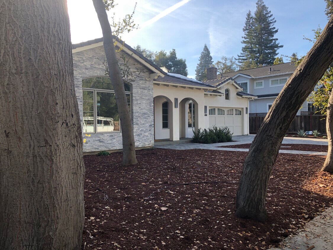
660 Coleridge Ave
Palo Alto, CA 94301
2 Weeks Ago
Favorites
660 Coleridge Ave

Favorites
Check Back Soon for Upcoming Availability
| Beds | Baths | Average SF |
|---|---|---|
| 7 Bedrooms 7 Bedrooms 7 Br | 7 Baths 7 Baths 7 Ba | 8,580 SF |
About This Property
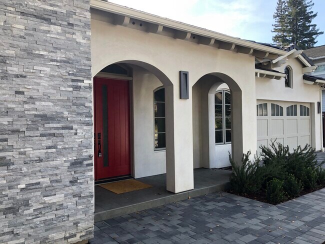
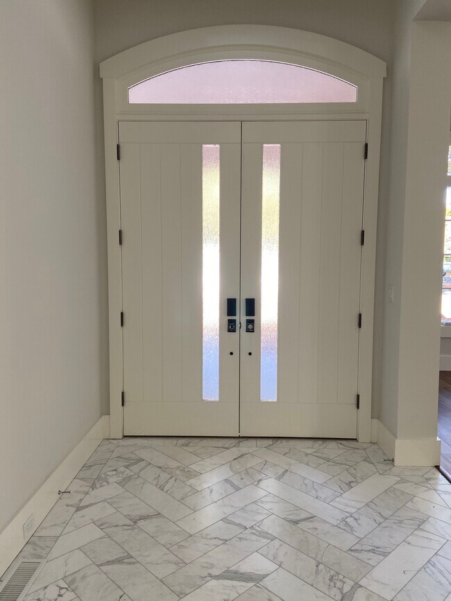
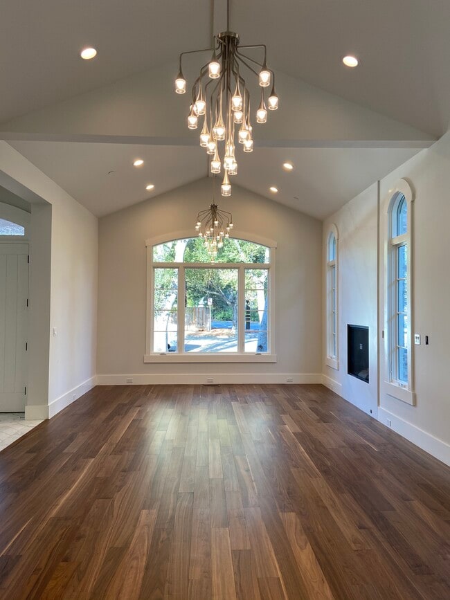
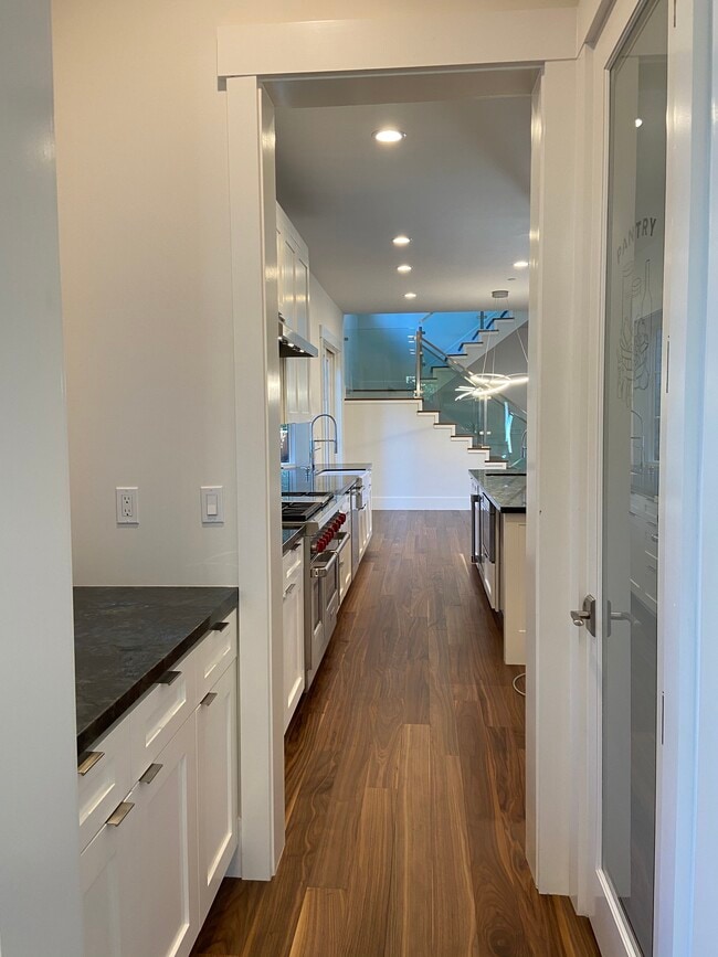
AVAILABLE TO MOVE IN MARCH 15th NEWLY CONSTRUCTED 7 Bedrooms 7.5 Bathrooms Newly constructed, never lived in, two story home (8580 sq. ft.) with basement. Perfect house for entertaining. This unique home has a centrally located open courtyard that brings natural light into the living space. The Family Room has folding glass doors to the courtyard and side patio to create a true open air breezeway. Beautiful hardwood floors throughout with radiant floor heating, as well as forced air heating. Formal entry with open Living Room and Dining Room, including gas fireplace, as well as walk-thru serving/pantry area to the Chef's Kitchen. All new high-end appliances including a six-burner and grill Wolf stove. Second floor has three bedrooms and private adjoining bathroom in each one, also access to balcony overlooking courtyard. Basement include large Living Room, Media Room, Home Theater Room, Exercise Room, Laundry Room and two bedrooms and two bathrooms. Two laundry rooms. Two-car garage with two EV Charging Stations. Two unique Japanese Soaking Tubs and Foot Soaking Tubs. Located in Palo Alto at the end of a block that does not allow through traffic. It is close to downtown, easy freeway access and equal distance to San Francisco and San Jose Airports. CALL OR TEXT ROB AT 650 - 222 - 8488
660 Coleridge Ave is a house located in Santa Clara County and the 94301 ZIP Code. This area is served by the Palo Alto Unified attendance zone.
House Features
- Washer/Dryer
- Washer/Dryer Hookup
- Dishwasher
Location
Get Directions
Palo Alto is known as the birthplace of Silicon Valley and that unique heritage is proudly on display, with the Computer History Museum just down the street from Google’s world headquarters and countless other tech companies all over town. The restaurant scene rivals that of nearby San Francisco, with many small, independent eateries serving up some of the best food in the Bay Area.
With close proximity to the country’s tech center, it’s no surprise that Palo Alto apartments come with some of the most incredible amenities around. Residents also have access to dozens of options for outdoor recreation, including the gorgeous hiking and biking trails through the surrounding nature preserves, several golf courses, and easy access to San Francisco Bay. Bicycling is a popular mode of transportation around Palo Alto, with many bike-friendly routes around the city.
Palo Alto is famous as the home of Stanford University, and the campus is one of the most dominant landmarks in the area.
Learn more about living in Palo AltoBelow are rent ranges for similar nearby apartments
Amenities
- Washer/Dryer
- Washer/Dryer Hookup
- Dishwasher
Education
| Colleges & Universities | Distance | ||
|---|---|---|---|
| Colleges & Universities | Distance | ||
| Drive: | 7 min | 2.3 mi | |
| Drive: | 10 min | 3.1 mi | |
| Drive: | 9 min | 3.6 mi | |
| Drive: | 16 min | 8.3 mi |
660 Coleridge Ave is within 7 minutes or 2.3 miles from Stanford University. It is also near Foothill College, Middlefield and Menlo College.
Schools


Public Elementary School
Grades K-5
367 Students
Nearby
Public Elementary School
Grades K-5
294 Students
Attendance Zone
Public Middle School
Grades 6-8
755 Students
Attendance Zone
Public High School
Grades 9-12
1,992 Students
Attendance Zone
Private Elementary & Middle School
Grades PK-8
Nearby
Private Elementary School
Grades K-6
Nearby
Private Middle & High School
Grades 6-12
430 Students
Nearby
School data provided by
 The GreatSchools Rating helps parents compare schools within a state based on a variety of school quality indicators and provides a helpful picture of how effectively each school serves all of its students. Ratings are on a scale of 1 (below average) to 10 (above average) and can include test scores, college readiness, academic progress, advanced courses, equity, discipline and attendance data. We also advise parents to visit schools, consider other information on school performance and programs, and consider family needs as part of the school selection process.
View GreatSchools Rating Methodology
Data provided by GreatSchools.org © 2025. All rights reserved.
View GreatSchools Rating Methodology
Data provided by GreatSchools.org © 2025. All rights reserved.
Transportation options available in Palo Alto include Mountain View Station, located 5.5 miles from 660 Coleridge Ave. 660 Coleridge Ave is near Norman Y Mineta San Jose International, located 14.3 miles or 21 minutes away, and San Francisco International, located 20.8 miles or 30 minutes away.
| Transit / Subway | Distance | ||
|---|---|---|---|
| Transit / Subway | Distance | ||
| Drive: | 11 min | 5.5 mi | |
|
|
Drive: | 11 min | 5.5 mi |
| Drive: | 11 min | 6.8 mi | |
|
|
Drive: | 12 min | 6.9 mi |
|
|
Drive: | 13 min | 7.3 mi |
| Commuter Rail | Distance | ||
|---|---|---|---|
| Commuter Rail | Distance | ||
| Drive: | 3 min | 1.3 mi | |
| Drive: | 4 min | 1.5 mi | |
| Drive: | 5 min | 1.9 mi | |
| Drive: | 7 min | 3.0 mi | |
| Drive: | 9 min | 4.1 mi |
| Airports | Distance | ||
|---|---|---|---|
| Airports | Distance | ||
|
Norman Y Mineta San Jose International
|
Drive: | 21 min | 14.3 mi |
|
San Francisco International
|
Drive: | 30 min | 20.8 mi |
Time and distance from 660 Coleridge Ave.
| Shopping Centers | Distance | ||
|---|---|---|---|
| Shopping Centers | Distance | ||
| Walk: | 19 min | 1.0 mi | |
| Drive: | 4 min | 1.4 mi | |
| Drive: | 8 min | 2.5 mi |
660 Coleridge Ave has 3 shopping centers within 2.5 miles, which is about a 8-minute walk. The miles and minutes will be for the farthest away property.
| Parks and Recreation | Distance | ||
|---|---|---|---|
| Parks and Recreation | Distance | ||
|
Junior Museum and Zoo
|
Walk: | 2 min | 0.2 mi |
|
Rinconada Park
|
Walk: | 5 min | 0.3 mi |
|
Gamble Garden
|
Walk: | 7 min | 0.4 mi |
|
Hopkins Creekside Park
|
Drive: | 5 min | 1.7 mi |
|
El Palo Alto Park
|
Drive: | 7 min | 2.3 mi |
660 Coleridge Ave has 5 parks within 2.3 miles, including Junior Museum and Zoo, Rinconada Park, and Gamble Garden.
| Hospitals | Distance | ||
|---|---|---|---|
| Hospitals | Distance | ||
| Drive: | 6 min | 2.1 mi | |
| Drive: | 7 min | 2.6 mi | |
| Drive: | 13 min | 7.2 mi |
660 Coleridge Ave has 3 hospitals within 7.2 miles, the nearest is Lucile Salter Packard Children's Hospital at Stanford which is 2.1 miles away and a 6 minute drive.
| Military Bases | Distance | ||
|---|---|---|---|
| Military Bases | Distance | ||
| Drive: | 14 min | 7.2 mi |
660 Coleridge Ave is 7.2 miles and a 14 minute drive from Ames Research Center.
You May Also Like
Similar Rentals Nearby


What Are Walk Score®, Transit Score®, and Bike Score® Ratings?
Walk Score® measures the walkability of any address. Transit Score® measures access to public transit. Bike Score® measures the bikeability of any address.
What is a Sound Score Rating?
A Sound Score Rating aggregates noise caused by vehicle traffic, airplane traffic and local sources

660 Coleridge Ave
Palo Alto, CA 94301