
66 Tirrell St Unit U:1R
66 Tirrell St Unit U:1R
Quincy, MA 02171
2 Weeks Ago
Favorites
66 Tirrell St Unit U:1R

Favorites
Check Back Soon for Upcoming Availability
| Beds | Baths | Average SF |
|---|---|---|
| 2 Bedrooms 2 Bedrooms 2 Br | 1 Bath 1 Bath 1 Ba | — |
Fees and Policies
The fees below are based on community-supplied data and may exclude additional fees and utilities.
Details
Utilities Included
-
Water
-
Sewer
About This Property
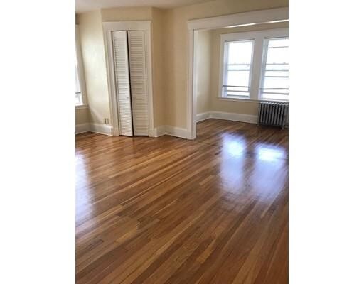
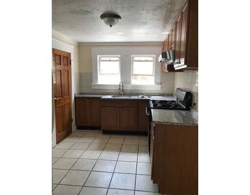
Location ! Location ! Location ! 15 minutes Walk to everything -----N Quincy T station, Walgreen, TD bank, gas station and restaurants. 2 Minutes to bus stop. 5 minutes to Dunkin Donut, CVS and the beautiful Wollaston Beach. The unit is newly painted. Open kitchen with granite counter top to a cozy living room. Washer and Dryer in closet. One standard bedroom is 10x12, The other huge bedroom 12x14, with a extend room for walk in closet or small office area 10x6. Newly polished hardwood flooring. Available right now!
66 Tirrell St is a condo located in Norfolk County and the 02171 ZIP Code.
Condo Features
- Range
- Refrigerator
Location
Get Directions
Just a short drive down I-93 from downtown Boston, Quincy is rich in history, with many landmarks commemorating key moments and figures from the American Revolution. Presidents John Adams and John Quincy Adams, both born in Quincy, are the namesakes of several parks, museums, and other public facilities around town.
Quincy’s close proximity to Boston allows residents to take advantage of the larger city’s many cultural resources, with Franklin Park Zoo and the John F. Kennedy Presidential Library and Museum particularly close by. Home of New England’s largest marina and 27 miles of coastline, boating and sailing are very popular in Quincy. Marina Bay is one of the most popular attractions in Quincy, offering beautiful views of the Boston skyline and world-class waterfront dining. To the west, Blue Hills Reservation serves hiking enthusiasts and nature lovers from all over the Massachusetts Bay area.
Learn more about living in Quincy
Amenities
- Range
- Refrigerator
Expenses
Utilities Included
Water, Sewer
Included
Education
| Colleges & Universities | Distance | ||
|---|---|---|---|
| Colleges & Universities | Distance | ||
| Drive: | 9 min | 4.2 mi | |
| Drive: | 12 min | 6.6 mi | |
| Drive: | 13 min | 6.6 mi | |
| Drive: | 13 min | 6.9 mi |
66 Tirrell St Unit U:1R is within 9 minutes or 4.2 miles from UMass Boston. It is also near Northeastern University and Wentworth Inst. of Technology.
Transportation options available in Quincy include North Quincy Station, located 1.5 miles from 66 Tirrell St Unit U:1R. 66 Tirrell St Unit U:1R is near General Edward Lawrence Logan International, located 9.5 miles or 17 minutes away.
| Transit / Subway | Distance | ||
|---|---|---|---|
| Transit / Subway | Distance | ||
|
|
Drive: | 4 min | 1.5 mi |
|
|
Drive: | 4 min | 1.9 mi |
|
|
Drive: | 5 min | 2.8 mi |
|
|
Drive: | 8 min | 3.3 mi |
|
|
Drive: | 7 min | 3.4 mi |
| Commuter Rail | Distance | ||
|---|---|---|---|
| Commuter Rail | Distance | ||
|
|
Drive: | 8 min | 3.1 mi |
|
|
Drive: | 7 min | 4.0 mi |
| Drive: | 10 min | 4.1 mi | |
| Drive: | 9 min | 4.3 mi | |
|
|
Drive: | 9 min | 4.5 mi |
| Airports | Distance | ||
|---|---|---|---|
| Airports | Distance | ||
|
General Edward Lawrence Logan International
|
Drive: | 17 min | 9.5 mi |
Time and distance from 66 Tirrell St Unit U:1R.
| Shopping Centers | Distance | ||
|---|---|---|---|
| Shopping Centers | Distance | ||
| Drive: | 4 min | 1.5 mi | |
| Drive: | 3 min | 1.6 mi | |
| Drive: | 5 min | 2.1 mi |
66 Tirrell St Unit U:1R has 3 shopping centers within 2.1 miles, which is about a 5-minute drive. The miles and minutes will be for the farthest away property.
| Parks and Recreation | Distance | ||
|---|---|---|---|
| Parks and Recreation | Distance | ||
|
Squantum Point Park
|
Drive: | 5 min | 1.6 mi |
|
Adams National Historical Park
|
Drive: | 7 min | 3.1 mi |
|
Dorchester Shores Reservation
|
Drive: | 9 min | 4.1 mi |
|
Franklin Park Zoo
|
Drive: | 10 min | 5.9 mi |
|
Lower Neponset River Trail
|
Drive: | 10 min | 6.0 mi |
66 Tirrell St Unit U:1R has 5 parks within 6.0 miles, including Squantum Point Park, Adams National Historical Park, and Lower Neponset River Trail.
| Hospitals | Distance | ||
|---|---|---|---|
| Hospitals | Distance | ||
| Drive: | 6 min | 3.1 mi | |
| Drive: | 10 min | 4.5 mi | |
| Drive: | 10 min | 5.6 mi |
66 Tirrell St Unit U:1R has 3 hospitals within 5.6 miles, the nearest is Carney Hospital which is 3.1 miles away and a 6 minute drive.
You May Also Like
Similar Rentals Nearby
-
-

-
1 / 21

-

-

-

-

-
-
-


What Are Walk Score®, Transit Score®, and Bike Score® Ratings?
Walk Score® measures the walkability of any address. Transit Score® measures access to public transit. Bike Score® measures the bikeability of any address.
What is a Sound Score Rating?
A Sound Score Rating aggregates noise caused by vehicle traffic, airplane traffic and local sources

66 Tirrell St
Quincy, MA 02171