

$1,300
Total Monthly Price
66 Providence St
Worcester, MA 01604
Favorites
66 Providence St

Favorites
Check Back Soon for Upcoming Availability
| Beds | Baths | Average SF |
|---|---|---|
| 3 Bedrooms 3 Bedrooms 3 Br | 1 Bath 1 Bath 1 Ba | — |
About This Property
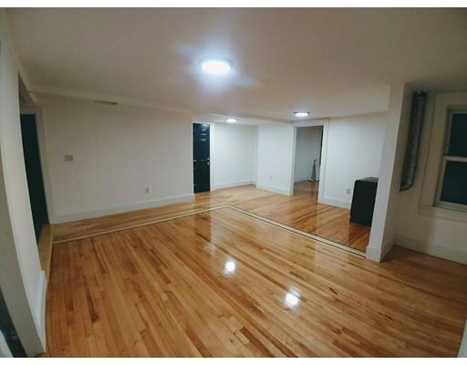
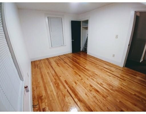
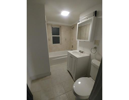
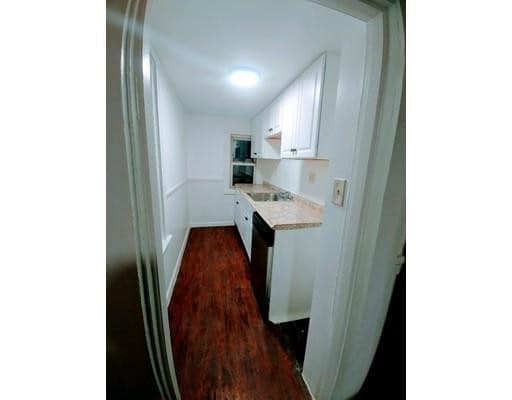
Be the first to live in this spacious newly remodel 3 bedroom. Master bedroom is a great size with walk in closet that can also fit a desk. Refinished hardwood floors throughout the entire unit. New Stainless steel fridge, along with a new stainless steel dishwasher. The other two rooms are a good size as well. Plenty of room in the living room for multiple couches. Has a deck in the back of unit where you can enjoy the fall days. Newly tiled bathroom. This unit is in close proximity to multiple universities, hospitals, lakes and many restaurants.
66 Providence St is a house located in Worcester County and the 01604 ZIP Code. This area is served by the Worcester School District attendance zone.
66 Providence St,
Worcester,
MA
01604
Union Hill sits less than two miles southeast of Downtown Worcester, just on the other side of the I-290. Home to many historic homes and buildings, Union Hill is a primarily residential neighborhood convenient to a range of popular restaurants. Some mainstays near the neighborhood include Wholly Cannoli, Bocado Tapas Bar, BirchTree Bread Company, and Smokestack Urban Barbecue.
Union Hill’s proximity to a number of colleges and universities makes it a choice location for students and faculty. Clark University, Worcester Polytechnic Institute, Worcester State University, University of Massachusetts Medical School, College of the Holy Cross, and Becker College are all a short distance from Union Hill.
Options for outdoor recreation abound near Union Hill with the presence of Lake Quinsigamond, Crompton Park, Cristoforo Colombo Park, Crow Hill Conservation Restriction, and Broad Meadow Brook Conservation Restriction.
Learn more about living in Union HIllBelow are rent ranges for similar nearby apartments
Expenses
Utilities Included
Water, Sewer
Included
Education
| Colleges & Universities | Distance | ||
|---|---|---|---|
| Colleges & Universities | Distance | ||
| Drive: | 2 min | 1.1 mi | |
| Drive: | 3 min | 1.8 mi | |
| Drive: | 4 min | 2.1 mi | |
| Drive: | 6 min | 2.4 mi |
66 Providence St is within 2 minutes or 1.1 miles from MCPHS University, Worcester. It is also near Becker College, Worcester and Clark University.
Schools


Public Elementary School
Grades PK-5
362 Students
Attendance Zone
Public Elementary School
Grades K-5
383 Students
Attendance Zone
Public Middle & High School
Grades 6-12
224 Students
Attendance Zone
Public Middle School
Grades 6-8
781 Students
Attendance Zone
Public High School
Grades 9-12
1,377 Students
Attendance Zone
Private Elementary, Middle & High School
Grades PK-12
193 Students
Nearby
Private Middle & High School
Grades 6-12
508 Students
Nearby
School data provided by
 The GreatSchools Rating helps parents compare schools within a state based on a variety of school quality indicators and provides a helpful picture of how effectively each school serves all of its students. Ratings are on a scale of 1 (below average) to 10 (above average) and can include test scores, college readiness, academic progress, advanced courses, equity, discipline and attendance data. We also advise parents to visit schools, consider other information on school performance and programs, and consider family needs as part of the school selection process.
View GreatSchools Rating Methodology
Data provided by GreatSchools.org © 2026. All rights reserved.
View GreatSchools Rating Methodology
Data provided by GreatSchools.org © 2026. All rights reserved.
Walkability Near 66 Providence St Worcester, MA 01604
Getting Around
 What do Walkability, Transit, Drivability, and Bikeability mean?
Walkability measures the walking distance to day-to-day needs.
Transit measures access to public transportation.
Drivability measures congestion, parking availability, and access to major roads.
Bikeability measures the suitability for cycling.
How It Works
What do Walkability, Transit, Drivability, and Bikeability mean?
Walkability measures the walking distance to day-to-day needs.
Transit measures access to public transportation.
Drivability measures congestion, parking availability, and access to major roads.
Bikeability measures the suitability for cycling.
How It Works
Very Walkable
Walkability
80
/ 100
Some Public Transit
Transit
50
/ 100
Moderately Drivable
Drivability
60
/ 100
Fairly Bikeable
Bikeability
50
/ 100
Scores provided by
-
Soundscore™
-
/ 100
Traffic
-Airport
-Businesses
-Scores provided by
HowLoud What is a Sound Score Rating? A Sound Score Rating aggregates noise caused by vehicle traffic, airplane traffic and local sources. How It WorksYou May Also Like
Similar Rentals Nearby
-
-

-

-

-

-

-

-

-
 3 Beds, 2 Baths, 2,663 sq ft$3,000Total Monthly PriceTotal Monthly Price NewPrices include all required monthly fees.8 Minthorne St
 -
 3 Beds, 2 Baths, 1,152 sq ft$3,150Total Monthly PriceTotal Monthly Price NewPrices include all required monthly fees.26 Steven Rd
What Are Walk Score®, Transit Score®, and Bike Score® Ratings?
Walk Score® measures the walkability of any address. Transit Score® measures access to public transit. Bike Score® measures the bikeability of any address.
What is a Sound Score Rating?
A Sound Score Rating aggregates noise caused by vehicle traffic, airplane traffic and local sources.

66 Providence St
Worcester, MA 01604