

$2,900
/ Month
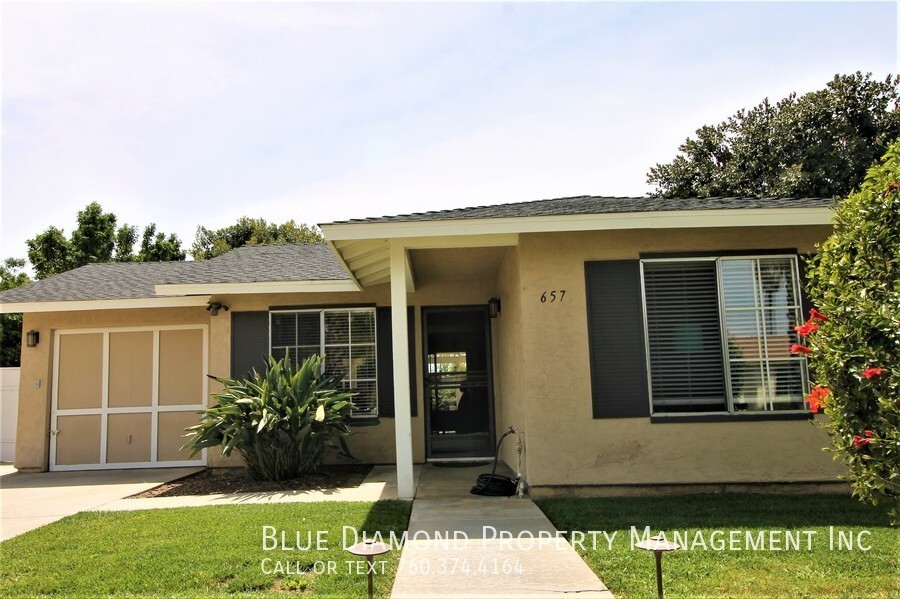
657 Cedar St
San Marcos, CA 92069
2 Weeks Ago
|
Edit
Favorites
657 Cedar St

Favorites
Check Back Soon for Upcoming Availability
| Beds | Baths | Average SF |
|---|---|---|
| 2 Bedrooms 2 Bedrooms 2 Br | 2 Baths 2 Baths 2 Ba | 950 SF |
Fees and Policies
The fees below are based on community-supplied data and may exclude additional fees and utilities.
- Parking
-
Garage--Assigned Parking
-
Other--Assigned Parking
About This Property
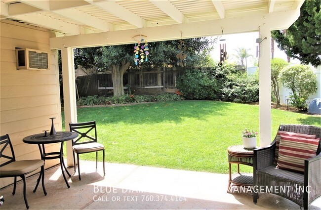
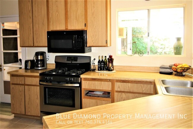
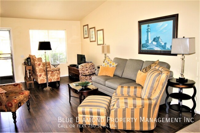
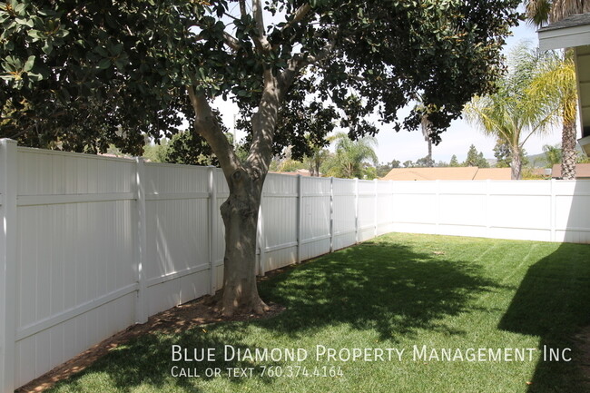
---- SCHEDULE A SHOWING ONLINE AT: ---- Lovely and spacious 2 BR, 2 BA home with large luscious yard. Corner lot in Peacock Hills with walking trails close by. Washer and dryer and all appliances included, less than 1 year old. This beauty is available soon.
657 Cedar St is a house located in San Diego County and the 92069 ZIP Code. This area is served by the San Marcos Unified attendance zone.
House Features
Washer/Dryer
Dishwasher
Microwave
Refrigerator
- Washer/Dryer
- Dishwasher
- Disposal
- Microwave
- Refrigerator
Location
Get Directions
You’ll want to add this premier Southern California suburbia to your wish list of places to live. With both mountain and ocean views, there’s nothing more scenic than living in this city. Enjoy upscale apartments, modern condos and townhomes, and houses for rent that resemble the west coast lifestyle. Palm trees, luxurious pools, and Southern California style permeate through these pristine rentals!
San Marcos houses California State University San Marcos and Palomar College, and the city is known for its renowned public schools in the San Marcos Unified School District. If you’re commuting to nearby cities for work, such as San Diego, located just 35 miles south of town, you’ll appreciate access to major interstates and a light rail system.
Let’s get back to San Marcos scenic views, shall we? Just a few miles east of the Pacific Ocean, this city boasts incredible ocean views that pair perfectly with views of Palomar Mountain and the Cleveland National Forest to the east.
Learn more about living in San Marcos
Amenities
- Washer/Dryer
- Dishwasher
- Disposal
- Microwave
- Refrigerator
Education
| Colleges & Universities | Distance | ||
|---|---|---|---|
| Colleges & Universities | Distance | ||
| Walk: | 15 min | 0.8 mi | |
| Drive: | 5 min | 2.3 mi | |
| Drive: | 7 min | 2.5 mi | |
| Drive: | 16 min | 11.2 mi |
657 Cedar St is within 15 minutes or 0.8 mile from USAHS. It is also near Palomar College and CSU San Marcos.
Schools


Public Elementary, Middle & High School
Grades K-12
59 Students
Nearby
Public Elementary School
Grades K-5
823 Students
Attendance Zone
Public Middle School
Grades 6-8
1,183 Students
Attendance Zone
Public High School
Grades 9-12
2,893 Students
Attendance Zone
Private Elementary, Middle & High School
Grades 1-12
Nearby
Private Elementary & Middle School
Grades PK-8
Nearby
Private Elementary School
Grades K-3
Nearby
School data provided by
 The GreatSchools Rating helps parents compare schools within a state based on a variety of school quality indicators and provides a helpful picture of how effectively each school serves all of its students. Ratings are on a scale of 1 (below average) to 10 (above average) and can include test scores, college readiness, academic progress, advanced courses, equity, discipline and attendance data. We also advise parents to visit schools, consider other information on school performance and programs, and consider family needs as part of the school selection process.
View GreatSchools Rating Methodology
Data provided by GreatSchools.org © 2025. All rights reserved.
View GreatSchools Rating Methodology
Data provided by GreatSchools.org © 2025. All rights reserved.
Transportation options available in San Marcos include San Marcos Civic Center, located 1.2 miles from 657 Cedar St. 657 Cedar St is near San Diego International, located 34.5 miles or 46 minutes away.
| Transit / Subway | Distance | ||
|---|---|---|---|
| Transit / Subway | Distance | ||
|
|
Drive: | 2 min | 1.2 mi |
|
|
Drive: | 4 min | 2.3 mi |
|
|
Drive: | 5 min | 2.3 mi |
|
|
Drive: | 4 min | 2.5 mi |
|
|
Drive: | 8 min | 4.7 mi |
| Commuter Rail | Distance | ||
|---|---|---|---|
| Commuter Rail | Distance | ||
|
|
Drive: | 20 min | 11.9 mi |
|
|
Drive: | 24 min | 13.4 mi |
|
|
Drive: | 22 min | 15.5 mi |
|
|
Drive: | 24 min | 17.2 mi |
|
|
Drive: | 29 min | 18.3 mi |
| Airports | Distance | ||
|---|---|---|---|
| Airports | Distance | ||
|
San Diego International
|
Drive: | 46 min | 34.5 mi |
Time and distance from 657 Cedar St.
| Shopping Centers | Distance | ||
|---|---|---|---|
| Shopping Centers | Distance | ||
| Walk: | 17 min | 0.9 mi | |
| Walk: | 18 min | 0.9 mi | |
| Walk: | 20 min | 1.0 mi |
657 Cedar St has 3 shopping centers within 1.0 miles, which is about a 20-minute walk. The miles and minutes will be for the farthest away property.
| Parks and Recreation | Distance | ||
|---|---|---|---|
| Parks and Recreation | Distance | ||
|
Palomar College Arboretum
|
Drive: | 4 min | 2.3 mi |
|
Del Dios Preserve
|
Drive: | 13 min | 6.9 mi |
|
Felicita County Park
|
Drive: | 13 min | 7.5 mi |
|
Kit Carson Park
|
Drive: | 16 min | 9.9 mi |
|
Queen Califia's Magical Circle
|
Drive: | 16 min | 10.0 mi |
657 Cedar St has 5 parks within 10.0 miles, including Palomar College Arboretum, Del Dios Preserve, and Felicita County Park.
| Hospitals | Distance | ||
|---|---|---|---|
| Hospitals | Distance | ||
| Drive: | 11 min | 6.2 mi | |
| Drive: | 14 min | 10.7 mi |
657 Cedar St is 6.2 miles from Palomar Health Downtown Campus, and is convenient to other hospitals, including Tri - City Medical Center.
| Military Bases | Distance | ||
|---|---|---|---|
| Military Bases | Distance | ||
| Drive: | 35 min | 21.5 mi | |
| Drive: | 44 min | 30.9 mi |
657 Cedar St is 21.5 miles from USMC Air Station Miramar, and is convenient to other military bases, including Marine Corps Base Camp Pendleton.
You May Also Like
Similar Rentals Nearby


What Are Walk Score®, Transit Score®, and Bike Score® Ratings?
Walk Score® measures the walkability of any address. Transit Score® measures access to public transit. Bike Score® measures the bikeability of any address.
What is a Sound Score Rating?
A Sound Score Rating aggregates noise caused by vehicle traffic, airplane traffic and local sources
657 Cedar St
San Marcos, CA 92069