


$1,500
/ Month
6343 N Claremont Ave
Chicago, IL 60659
Today
|
Edit
Favorites
312-462-4030
-
Bedrooms
2
-
Bathrooms
1
-
Square Feet
850 sq ft
-
Available
Available Now
Highlights
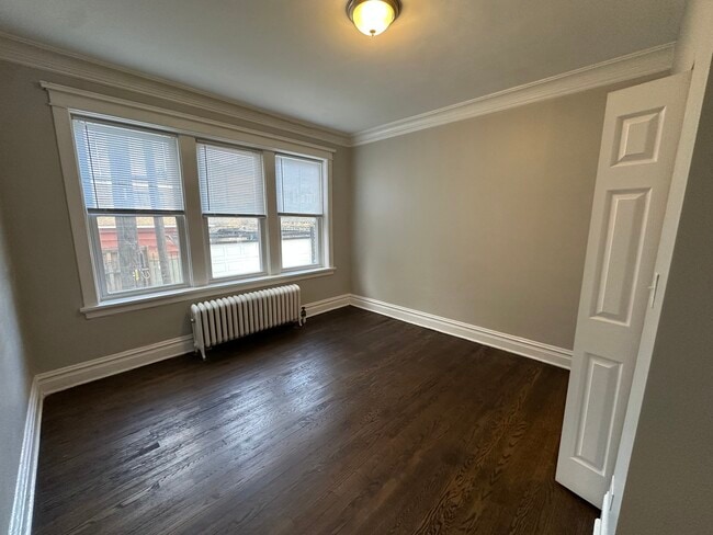
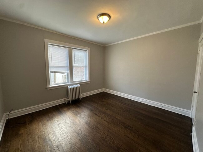
- Living Room
- Laundry Room
- Dining Room
- Family Room
- Dogs and Cats Allowed
6343 N Claremont Ave

Favorites
About This Home
Available Now
MLS# MRD12506462 Based on information submitted to the MLS GRID as of [see last changed date above]. All data is obtained from various sources and may not have been verified by broker or MLS GRID. Supplied Open House Information is subject to change without notice. All information should be independently reviewed and verified for accuracy. Properties may or may not be listed by the office/agent presenting the information. Some IDX listings have been excluded from this website. Prices displayed on all Sold listings are the Last Known Listing Price and may not be the actual selling price.
6343 N Claremont Ave is a house located in Cook County and the 60659 ZIP Code. This area is served by the Chicago Public Schools attendance zone.
* Price shown is base rent. Excludes user-selected optional fees and variable or usage-based fees and required charges due at or prior to move-in or at move-out. Price, availability, fees, and any applicable rent special are subject to change without notice.
* Square footage definitions vary. Displayed square footage is approximate.
Home Details
Year Built
Built in 1924
Bedrooms and Bathrooms
1 Full Bathroom
2 Bedrooms
2 Potential Bedrooms
Home Design
Brick Exterior Construction
Property Attached
Entry on the 1st floor
Interior Spaces
Living Room
Dining Room
Family Room
850 Sq Ft Home
3-Story Property
Laundry
Laundry Room
Listing and Financial Details
Property Available on 10/29/25
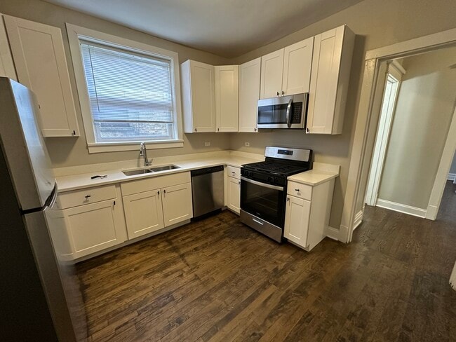
Rent includes heat, water
Parking
3 Parking Spaces
Utilities
Radiator
No Cooling
Lake Michigan Water
Community Details
Overview
6 Units
Pet Policy
Dogs and Cats Allowed
Limit on the number of pets
Fees and Policies
The fees below are based on community-supplied data and may exclude additional fees and utilities.
- Dogs
- Allowed
- Cats
- Allowed
Property Fee Disclaimer: Based on community-supplied data and independent market research. Subject to change without notice. May exclude fees for mandatory or optional services and usage-based utilities.
Contact
- Listed by Rachel Leva | Silver Property Group,Ltd
- Phone Number
- Contact
-
Source
 Midwest Real Estate Data LLC
Copyright © 2025 Midwest Real Estate Data, LLC. All rights reserved. All information provided by the listing agent/broker is deemed reliable but is not guaranteed and should be independently verified.
Location
Get Directions
West Ridge Park is located on the far north side of Chicago, an upscale community encompassed with tree-lined streets, multicultural establishments, and historic homes.
Many diverse restaurants can be found along West Devon Avenue, which is a couple of blocks south of Robert A. Black Golf Course. Many green spaces make up West Rogers Park, including Mather Park and Indian Boundary Park.
Residents of this lush Chicago community enjoy proximity to Rogers Park Train Station, Loyola Beach, and Lincoln Town Center mall.
Learn more about living in West Rogers Park
Education
| Colleges & Universities | Distance | ||
|---|---|---|---|
| Colleges & Universities | Distance | ||
| Drive: | 4 min | 1.8 mi | |
| Drive: | 7 min | 2.8 mi | |
| Drive: | 6 min | 2.9 mi | |
| Drive: | 7 min | 3.5 mi |
6343 N Claremont Ave is within 4 minutes or 1.8 miles from Loyola University, Lakeshore. It is also near Northeastern Ill. Univ. and North Park University.
Schools


Public Elementary & Middle School
Grades PK-8
1,248 Students
Attendance Zone
Public High School
Grades 9-12
1,583 Students
Attendance Zone
Private Elementary, Middle & High School
Grades K-12
Nearby
Private Elementary, Middle & High School
Grades PK-12
Nearby
School data provided by
 The GreatSchools Rating helps parents compare schools within a state based on a variety of school quality indicators and provides a helpful picture of how effectively each school serves all of its students. Ratings are on a scale of 1 (below average) to 10 (above average) and can include test scores, college readiness, academic progress, advanced courses, equity, discipline and attendance data. We also advise parents to visit schools, consider other information on school performance and programs, and consider family needs as part of the school selection process.
View GreatSchools Rating Methodology
Data provided by GreatSchools.org © 2025. All rights reserved.
View GreatSchools Rating Methodology
Data provided by GreatSchools.org © 2025. All rights reserved.
Transportation options available in Chicago include Loyola Station, located 1.7 miles from 6343 N Claremont Ave. 6343 N Claremont Ave is near Chicago O'Hare International, located 12.9 miles or 23 minutes away, and Chicago Midway International, located 17.1 miles or 32 minutes away.
| Transit / Subway | Distance | ||
|---|---|---|---|
| Transit / Subway | Distance | ||
|
|
Drive: | 4 min | 1.7 mi |
|
|
Drive: | 4 min | 1.8 mi |
|
|
Drive: | 5 min | 2.2 mi |
|
|
Drive: | 5 min | 2.4 mi |
|
|
Drive: | 5 min | 2.5 mi |
| Commuter Rail | Distance | ||
|---|---|---|---|
| Commuter Rail | Distance | ||
| Drive: | 2 min | 1.1 mi | |
|
|
Drive: | 5 min | 1.7 mi |
|
|
Drive: | 6 min | 3.1 mi |
|
|
Drive: | 7 min | 3.3 mi |
|
|
Drive: | 7 min | 3.9 mi |
| Airports | Distance | ||
|---|---|---|---|
| Airports | Distance | ||
|
Chicago O'Hare International
|
Drive: | 23 min | 12.9 mi |
|
Chicago Midway International
|
Drive: | 32 min | 17.1 mi |
Time and distance from 6343 N Claremont Ave.
| Shopping Centers | Distance | ||
|---|---|---|---|
| Shopping Centers | Distance | ||
| Walk: | 14 min | 0.8 mi | |
| Drive: | 3 min | 1.3 mi | |
| Drive: | 3 min | 1.4 mi |
6343 N Claremont Ave has 3 shopping centers within 1.4 miles, which is about a 3-minute walk. The miles and minutes will be for the farthest away property.
| Parks and Recreation | Distance | ||
|---|---|---|---|
| Parks and Recreation | Distance | ||
|
Warren Park
|
Walk: | 10 min | 0.6 mi |
|
Rogers Park
|
Drive: | 4 min | 1.7 mi |
|
Winnemac Park
|
Drive: | 5 min | 2.0 mi |
|
Touhy Park
|
Drive: | 5 min | 2.3 mi |
|
North Park Village Nature Center
|
Drive: | 5 min | 2.8 mi |
6343 N Claremont Ave has 5 parks within 2.8 miles, including Warren Park, Rogers Park, and Winnemac Park.
| Hospitals | Distance | ||
|---|---|---|---|
| Hospitals | Distance | ||
| Drive: | 4 min | 2.1 mi | |
| Drive: | 4 min | 2.2 mi | |
| Drive: | 5 min | 2.6 mi |
6343 N Claremont Ave has 3 hospitals within 2.6 miles, the nearest is Swedish Covenant Hospital which is 2.1 miles away and a 4 minute drive.
| Military Bases | Distance | ||
|---|---|---|---|
| Military Bases | Distance | ||
| Drive: | 32 min | 20.5 mi |
6343 N Claremont Ave is 20.5 miles and a 32 minute drive from US Military Reservation Elk Grove.
You May Also Like
Similar Rentals Nearby


What Are Walk Score®, Transit Score®, and Bike Score® Ratings?
Walk Score® measures the walkability of any address. Transit Score® measures access to public transit. Bike Score® measures the bikeability of any address.
What is a Sound Score Rating?
A Sound Score Rating aggregates noise caused by vehicle traffic, airplane traffic and local sources
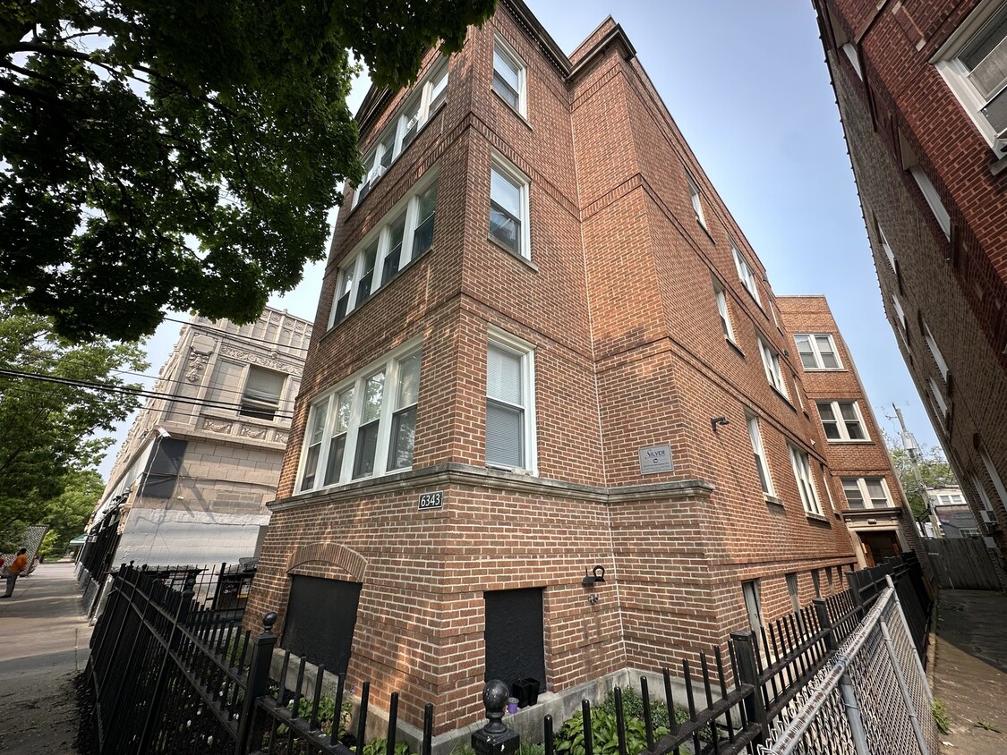
6343 N Claremont Ave
Chicago, IL 60659