
$3,688 / Month
620 Homer Ave
Palo Alto, CA 94301
Today
Favorites
650-271-7048
-
Bedrooms
2
-
Bathrooms
1
-
Square Feet
980 sq ft
-
Available
Available Now
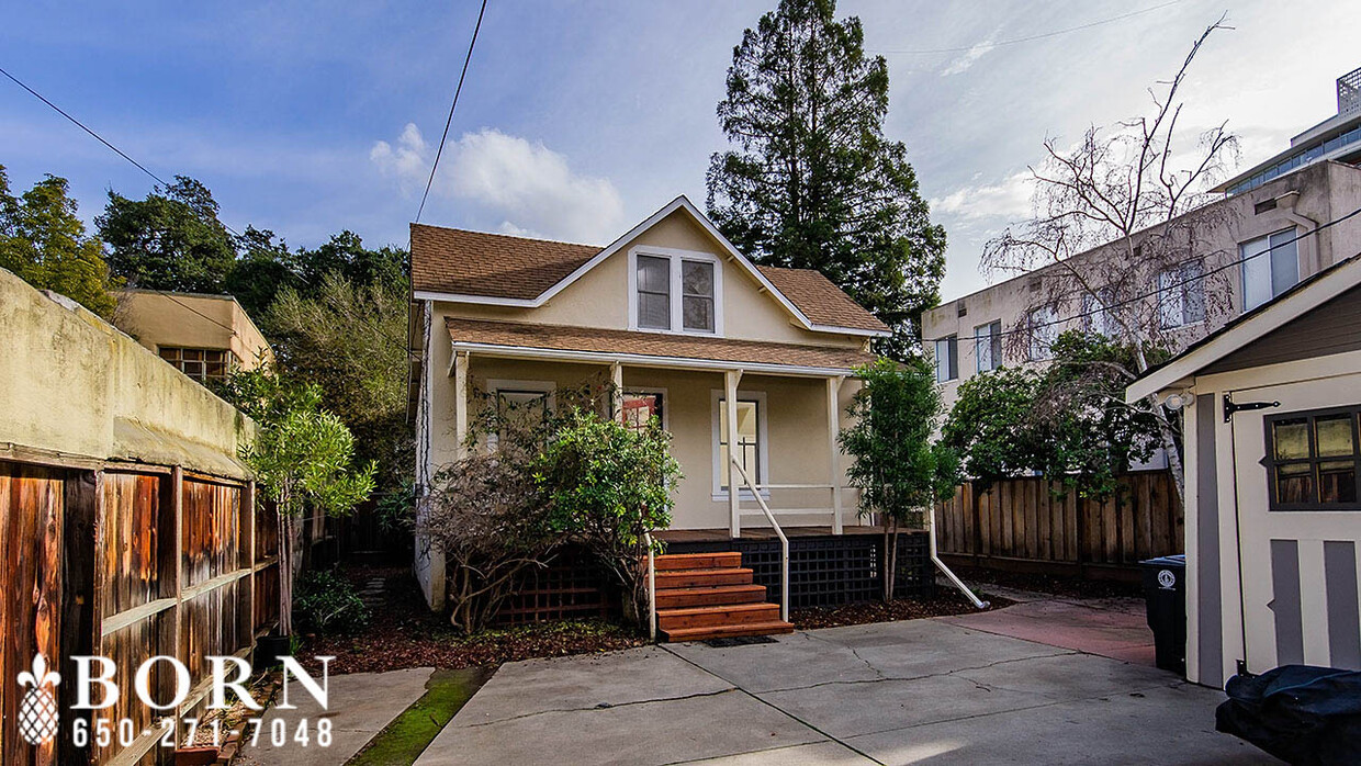
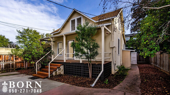
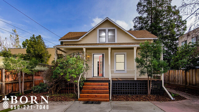
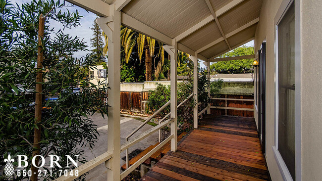
620 Homer Ave

Favorites
About This Home
$5,532 deposit,
Available Now
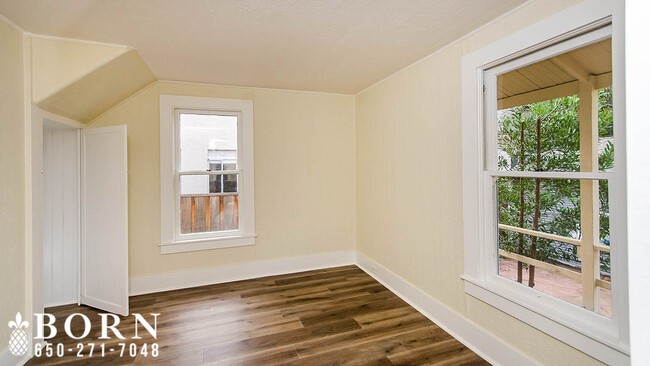
"Schedule an Appointment online, please visit: jasonborn.as.me/PAHomerAve620" "To See More Pics, please visit: " Step back in time and experience the charm of a 1928 Palo Alto 2 bedrooms 2 bath single-family home. This 980 sq ft home boasts hardwood floors and stainless steel appliances, providing the perfect blend of vintage character and modern convenience. Enjoy the convenience of being in the heart of the University South Neighborhood, with easy access to the best dining, shopping, and entertainment the city has to offer. Available 12 January 2023. NEIGHBORHOOD This home is ideally situated in the University South neighborhood... a fantastic location for commuters, near The Stanford Campus, and of course, Philz Coffee. LOCATION The City of Palo Alto is situated on San Francisco Peninsula, approximately 33 miles South of Downtown San Francisco, and 17 miles North of Downtown San Jose. AMENITIES A convenient area near amenities, such as Philz Coffee (.7 Miles), Midtown Shopping Center (1.7 Mile), Caltrain Palo Alto Station (.9 Miles), Stanford Shopping Center (1.1 Miles), Safeway Market (1 Mile), Mitchell Park Library (3 Mile). SCHOOLS (Public - Please Verify Availability) Palo Alto School District - Addison Elementary School (K-5), Frank S. Greene Jr Middle School (6-8), Palo Alto High School (9-12). Prices, requirements, terms, offers, and availability are all subject to change without notice. All information deemed reliable but not guaranteed or warranted and should be independently verified. Born Property Management CA License: 02002900
620 Homer Ave is a house located in Santa Clara County and the 94301 ZIP Code. This area is served by the Palo Alto Unified attendance zone.
* Price shown is base rent and may not include non-optional fees and utilities.
Price, availability, fees, and any applicable rent special are subject to change without notice.
* Square footage definitions vary. Displayed square footage is approximate.
House Features
- Washer/Dryer
- Range
- Refrigerator
Contact
- Listed by Jason Born
- Phone Number
- Contact
Location
Get Directions
Amenities
- Washer/Dryer
- Range
- Refrigerator
An outgoing vibe emanates from the Downtown North neighborhood. Downtown North provides an energy like no other in Palo Alto. Still, locals enjoy being part of a tight-knit community focused on safety, communication and most importantly: fun.
Palo Alto has one of the best public school systems in California, houses Stanford University, and has some of the most delicious dining and exciting shopping opportunities in the Bay Area. The placement of the city provides convenience for commuters to San Jose 24 miles to the Southeast or San Francisco 32 miles to the Northwest.
Learn more about living in Downtown Palo Alto
Education
| Colleges & Universities | Distance | ||
|---|---|---|---|
| Colleges & Universities | Distance | ||
| Drive: | 9 min | 2.7 mi | |
| Drive: | 9 min | 3.1 mi | |
| Drive: | 12 min | 5.7 mi | |
| Drive: | 18 min | 9.0 mi |
620 Homer Ave is within 9 minutes or 2.7 miles from Stanford University. It is also near Menlo College and Foothill College, Middlefield.
Schools


Public Elementary School
Grades K-5
331 Students
Attendance Zone
Public Elementary School
Grades K-5
367 Students
Nearby
Public Middle School
Grades 6-8
755 Students
Attendance Zone
Public High School
Grades 9-12
1,992 Students
Attendance Zone
Private Elementary School
Grades K-6
Nearby
Private Elementary & Middle School
Grades PK-8
Nearby
Private Middle & High School
Grades 6-12
430 Students
Nearby
School data provided by
 The GreatSchools Rating helps parents compare schools within a state based on a variety of school quality indicators and provides a helpful picture of how effectively each school serves all of its students. Ratings are on a scale of 1 (below average) to 10 (above average) and can include test scores, college readiness, academic progress, advanced courses, equity, discipline and attendance data. We also advise parents to visit schools, consider other information on school performance and programs, and consider family needs as part of the school selection process.
View GreatSchools Rating Methodology
Data provided by GreatSchools.org © 2025. All rights reserved.
View GreatSchools Rating Methodology
Data provided by GreatSchools.org © 2025. All rights reserved.
Transportation options available in Palo Alto include Bayshore Nasa Station, located 8.0 miles from 620 Homer Ave. 620 Homer Ave is near Norman Y Mineta San Jose International, located 15.6 miles or 23 minutes away, and San Francisco International, located 20.5 miles or 29 minutes away.
| Transit / Subway | Distance | ||
|---|---|---|---|
| Transit / Subway | Distance | ||
| Drive: | 13 min | 8.0 mi | |
|
|
Drive: | 13 min | 8.1 mi |
| Drive: | 13 min | 8.4 mi | |
|
|
Drive: | 13 min | 8.4 mi |
|
|
Drive: | 14 min | 8.6 mi |
| Commuter Rail | Distance | ||
|---|---|---|---|
| Commuter Rail | Distance | ||
| Walk: | 18 min | 0.9 mi | |
| Drive: | 5 min | 2.0 mi | |
| Drive: | 6 min | 2.3 mi | |
| Drive: | 7 min | 2.6 mi | |
| Drive: | 11 min | 4.8 mi |
| Airports | Distance | ||
|---|---|---|---|
| Airports | Distance | ||
|
Norman Y Mineta San Jose International
|
Drive: | 23 min | 15.6 mi |
|
San Francisco International
|
Drive: | 29 min | 20.5 mi |
Time and distance from 620 Homer Ave.
| Shopping Centers | Distance | ||
|---|---|---|---|
| Shopping Centers | Distance | ||
| Drive: | 4 min | 1.2 mi | |
| Drive: | 5 min | 1.5 mi | |
| Drive: | 6 min | 1.8 mi |
620 Homer Ave has 3 shopping centers within 1.8 miles, which is about a 6-minute drive. The miles and minutes will be for the farthest away property.
| Parks and Recreation | Distance | ||
|---|---|---|---|
| Parks and Recreation | Distance | ||
|
Junior Museum and Zoo
|
Walk: | 13 min | 0.7 mi |
|
Gamble Garden
|
Walk: | 16 min | 0.8 mi |
|
Rinconada Park
|
Walk: | 16 min | 0.8 mi |
|
Hopkins Creekside Park
|
Walk: | 20 min | 1.1 mi |
|
El Palo Alto Park
|
Drive: | 5 min | 1.6 mi |
620 Homer Ave has 5 parks within 1.6 miles, including Junior Museum and Zoo, Gamble Garden, and Rinconada Park.
| Hospitals | Distance | ||
|---|---|---|---|
| Hospitals | Distance | ||
| Drive: | 6 min | 1.9 mi | |
| Drive: | 7 min | 2.5 mi | |
| Drive: | 12 min | 6.9 mi |
620 Homer Ave has 3 hospitals within 6.9 miles, the nearest is Lucile Salter Packard Children's Hospital at Stanford which is 1.9 miles away and a 6 minute drive.
| Military Bases | Distance | ||
|---|---|---|---|
| Military Bases | Distance | ||
| Drive: | 16 min | 8.5 mi |
620 Homer Ave is 8.5 miles and a 16 minute drive from Ames Research Center.
You May Also Like
Similar Rentals Nearby


What Are Walk Score®, Transit Score®, and Bike Score® Ratings?
Walk Score® measures the walkability of any address. Transit Score® measures access to public transit. Bike Score® measures the bikeability of any address.
What is a Sound Score Rating?
A Sound Score Rating aggregates noise caused by vehicle traffic, airplane traffic and local sources

620 Homer Ave
Palo Alto, CA 94301