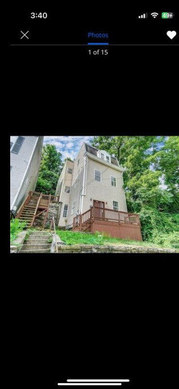
611 Tafel St
Cincinnati, OH 45225
-
Bedrooms
4
-
Bathrooms
2.5
-
Square Feet
1,998 sq ft
-
Available
Available Now

About This Home
Property Id: 2070040 Welcome to your dream home in Cincinnati, OH! This spacious 4 bedroom, 2.5 bathroom single-family unit on 611 Tafel St is perfect for those who love a modern lifestyle. Enjoy amenities like a dishwasher, washer/dryer, and central air. Rent for $2100/month starting on 08/01/2025. Don't miss out on this gem!
611 Tafel St is a house located in Hamilton County and the 45225 ZIP Code.
House Features
Washer/Dryer
Dishwasher
Microwave
Refrigerator
- Washer/Dryer
- Dishwasher
- Microwave
- Oven
- Refrigerator
- Freezer
Fees and Policies
The fees below are based on community-supplied data and may exclude additional fees and utilities.
Contact
- Phone Number
- Contact
-
Source

- Washer/Dryer
- Dishwasher
- Microwave
- Oven
- Refrigerator
- Freezer
In Clifton there’s plenty to do and see. The rolling hills, lush parks and green spaces, hip shopping, and affordable apartments create a vibrancy in Clifton that can’t be ignored.
In addition to its active art scene, the neighborhood is encompassing of Mount Storm Park, Edgewood Grove Park, and the Cincinnati State Technical and Community College. Locals enjoy the direct access to Interstate 75, making commutes in and around the city a breeze.
Clifton is just north of the 90-acre Burnet Woods Park and the University of Cincinnati campus. When you have a craving for something sweet or savory, head on over to the Clifton Gaslight District for every kind of cuisine imaginable. Clifton sits atop a hill overlooking the Northside, and Ludlow Avenue has been dubbed Cincinnati’s first “Main Street.
Learn more about living in Clifton| Colleges & Universities | Distance | ||
|---|---|---|---|
| Colleges & Universities | Distance | ||
| Drive: | 4 min | 1.4 mi | |
| Drive: | 6 min | 1.9 mi | |
| Drive: | 6 min | 1.9 mi | |
| Drive: | 12 min | 4.0 mi |
Transportation options available in Cincinnati include Brewery District Station, Elm & Henry, located 1.5 miles from 611 Tafel St. 611 Tafel St is near Cincinnati/Northern Kentucky International, located 17.6 miles or 32 minutes away.
| Transit / Subway | Distance | ||
|---|---|---|---|
| Transit / Subway | Distance | ||
| Drive: | 4 min | 1.5 mi | |
| Drive: | 4 min | 1.7 mi | |
| Drive: | 5 min | 1.8 mi | |
| Drive: | 5 min | 1.9 mi | |
| Drive: | 5 min | 2.0 mi |
| Commuter Rail | Distance | ||
|---|---|---|---|
| Commuter Rail | Distance | ||
|
|
Drive: | 7 min | 2.2 mi |
| Airports | Distance | ||
|---|---|---|---|
| Airports | Distance | ||
|
Cincinnati/Northern Kentucky International
|
Drive: | 32 min | 17.6 mi |
Time and distance from 611 Tafel St.
| Shopping Centers | Distance | ||
|---|---|---|---|
| Shopping Centers | Distance | ||
| Walk: | 17 min | 0.9 mi | |
| Drive: | 4 min | 1.7 mi | |
| Drive: | 4 min | 1.8 mi |
| Parks and Recreation | Distance | ||
|---|---|---|---|
| Parks and Recreation | Distance | ||
|
Trailside Nature Center
|
Drive: | 4 min | 1.3 mi |
|
Cincinnati Zoo and Botanical Garden
|
Drive: | 6 min | 1.9 mi |
|
Burnet Woods
|
Drive: | 5 min | 2.0 mi |
|
William H. Taft National Historic Site
|
Drive: | 6 min | 2.0 mi |
|
Duke Energy Children's Museum
|
Drive: | 7 min | 2.2 mi |
| Hospitals | Distance | ||
|---|---|---|---|
| Hospitals | Distance | ||
| Drive: | 4 min | 1.5 mi | |
| Drive: | 6 min | 1.9 mi | |
| Drive: | 6 min | 1.9 mi |
| Military Bases | Distance | ||
|---|---|---|---|
| Military Bases | Distance | ||
| Drive: | 69 min | 52.8 mi | |
| Drive: | 75 min | 57.9 mi | |
| Drive: | 78 min | 61.2 mi |
611 Tafel St Photos
Nearby Apartments
Within 50 Miles of 611 Tafel St Cincinnati, OH 45225
-
316 Klotter Ave
Cincinnati, OH 45219
5 Br $750 0.6 mi
-
3037 Worthington Ave
Cincinnati, OH 45211
4 Br $1,600 2.9 mi
-
4397 Virginia Ave
Cincinnati, OH 45223
5 Br $2,000 3.0 mi
-
1611 Clarewood Ave
Cincinnati, OH 45207
4 Br $2,800 3.0 mi
-
501 Delta Ave
Cincinnati, OH 45226
4 Br $2,500 4.9 mi
-
6816 Park Ave
Cincinnati, OH 45236
5 Br $2,500 7.8 mi
What Are Walk Score®, Transit Score®, and Bike Score® Ratings?
Walk Score® measures the walkability of any address. Transit Score® measures access to public transit. Bike Score® measures the bikeability of any address.
What is a Sound Score Rating?
A Sound Score Rating aggregates noise caused by vehicle traffic, airplane traffic and local sources
611 Tafel St
Cincinnati, OH 45225