$3,600 / Month
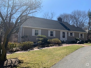
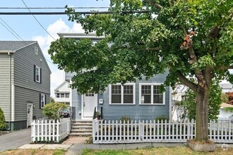
61 Evelyn Rd
Needham, MA 02494
2 Weeks Ago
Favorites
61 Evelyn Rd

Favorites
Check Back Soon for Upcoming Availability
| Beds | Baths | Average SF |
|---|---|---|
| 4 Bedrooms 4 Bedrooms 4 Br | 2 Baths 2 Baths 2 Ba | — |
About This Property
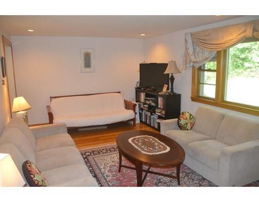
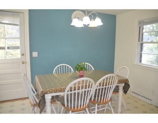
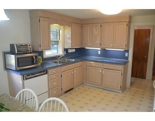
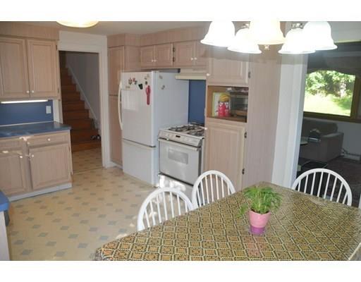
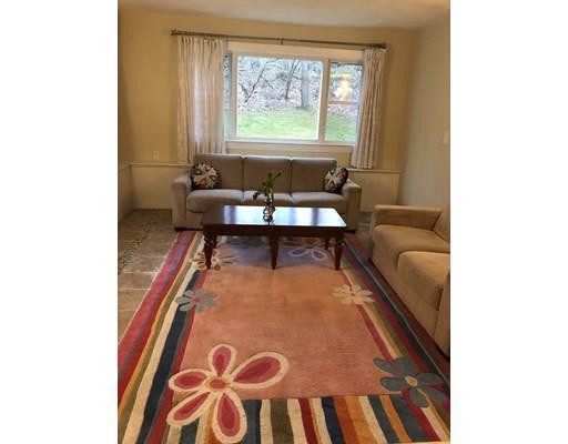
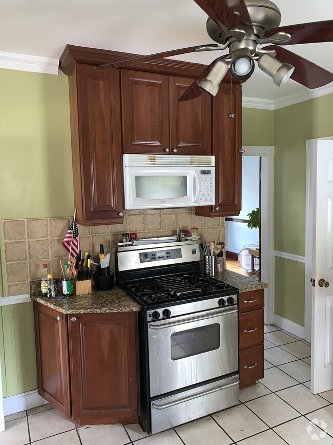
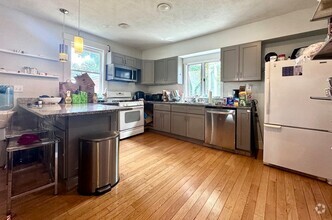
Can be rented out furnished! Wonderful opportunity in excellent neighborhood. A Large eat-in-kitchen and a charming living room with fireplace and sparkling wood floors looking out over the big back yard are located in the first floor. Up a half flight of stairs are a full bathroom and 3 bright and sunny bedrooms. Family room, 4th bedroom and full bathroom are located in the ground level. Laundry is located in the basement. A new central Air with Nest thermostat that can be controlled wirelessly. Needham’s Eliot elementary school is in walking distance and middle and high school are close by. 0.6 miles to Needham Heights train. Great price! First and last month rent plus one month security deposit will be collected upon of a lease signed. Needham is conveniently located in the Boston Metro West area, just minutes to all major highways and downtown Boston, excellent public schools, universities, hospitals, public transportation & shopping.
61 Evelyn Rd is a house located in Norfolk County and the 02494 ZIP Code. This area is served by the Needham attendance zone.
House Features
Air Conditioning
Dishwasher
Microwave
Refrigerator
- Air Conditioning
- Fireplace
- Dishwasher
- Microwave
- Range
- Refrigerator
Fees and Policies
The fees below are based on community-supplied data and may exclude additional fees and utilities.
Pet policies are negotiable.
Location
Get Directions
Just west of Boston and East of Worcester sits Metro West, a region that houses a group of towns and cities with significant historical backgrounds. A total of 19 municipalities make up the core of this community, but other municipalities are considered to be a part of the Interstate 495/Metro West Corridor.
Learn more about living in Metro WestBelow are rent ranges for similar nearby apartments
| Beds | Average Size | Lowest | Typical | Premium |
|---|---|---|---|---|
| Studio Studio Studio | 527-530 Sq Ft | $895 | $2,551 | $7,330 |
| 1 Bed 1 Bed 1 Bed | 790-792 Sq Ft | $1,495 | $3,016 | $10,753 |
| 2 Beds 2 Beds 2 Beds | 1159-1162 Sq Ft | $2,000 | $3,717 | $15,621 |
| 3 Beds 3 Beds 3 Beds | 1625-1630 Sq Ft | $2,190 | $4,993 | $23,197 |
| 4 Beds 4 Beds 4 Beds | 3602 Sq Ft | $1,025 | $6,514 | $20,000 |
Amenities
- Air Conditioning
- Fireplace
- Dishwasher
- Microwave
- Range
- Refrigerator
Education
| Colleges & Universities | Distance | ||
|---|---|---|---|
| Colleges & Universities | Distance | ||
| Drive: | 8 min | 3.9 mi | |
| Drive: | 13 min | 5.0 mi | |
| Drive: | 11 min | 5.5 mi | |
| Drive: | 12 min | 5.9 mi |
61 Evelyn Rd is within 8 minutes or 3.9 miles from Babson College. It is also near Wellesley College and Boston College.
Schools


Public Elementary School
Grades K-5
280 Students
Nearby
Public Elementary & Middle School
Grades 6
446 Students
Attendance Zone
Public Elementary School
Grades K-5
426 Students
Attendance Zone
Public Middle School
Grades 6-8
657 Students
Nearby
Public Middle School
Grades 7-8
818 Students
Attendance Zone
Public High School
Grades 9-12
1,645 Students
Attendance Zone
Private Elementary School
Grades PK-6
174 Students
Nearby
Private Elementary & Middle School
Grades PK-8
353 Students
Nearby
Private Middle & High School
Grades 7-12
9 Students
Nearby
Private Middle School
Grades 6-8
109 Students
Nearby
Private High School
Grades 9-12
10 Students
Nearby
School data provided by
 The GreatSchools Rating helps parents compare schools within a state based on a variety of school quality indicators and provides a helpful picture of how effectively each school serves all of its students. Ratings are on a scale of 1 (below average) to 10 (above average) and can include test scores, college readiness, academic progress, advanced courses, equity, discipline and attendance data. We also advise parents to visit schools, consider other information on school performance and programs, and consider family needs as part of the school selection process.
View GreatSchools Rating Methodology
View GreatSchools Rating Methodology
Transportation options available in Needham include Waban Station, located 2.2 miles from 61 Evelyn Rd. 61 Evelyn Rd is near General Edward Lawrence Logan International, located 15.7 miles or 28 minutes away, and Worcester Regional, located 42.2 miles or 61 minutes away.
| Transit / Subway | Distance | ||
|---|---|---|---|
| Transit / Subway | Distance | ||
|
|
Drive: | 6 min | 2.2 mi |
|
|
Drive: | 6 min | 2.5 mi |
|
|
Drive: | 5 min | 2.5 mi |
|
|
Drive: | 7 min | 3.1 mi |
|
|
Drive: | 8 min | 4.4 mi |
| Commuter Rail | Distance | ||
|---|---|---|---|
| Commuter Rail | Distance | ||
|
|
Walk: | 15 min | 0.8 mi |
|
|
Drive: | 3 min | 1.7 mi |
|
|
Drive: | 5 min | 2.3 mi |
|
|
Drive: | 6 min | 3.1 mi |
|
|
Drive: | 7 min | 3.3 mi |
| Airports | Distance | ||
|---|---|---|---|
| Airports | Distance | ||
|
General Edward Lawrence Logan International
|
Drive: | 28 min | 15.7 mi |
|
Worcester Regional
|
Drive: | 61 min | 42.2 mi |
Time and distance from 61 Evelyn Rd.
| Shopping Centers | Distance | ||
|---|---|---|---|
| Shopping Centers | Distance | ||
| Walk: | 19 min | 1.0 mi | |
| Drive: | 2 min | 1.1 mi | |
| Drive: | 3 min | 1.5 mi |
61 Evelyn Rd has 3 shopping centers within 1.5 miles, which is about a 3-minute walk. The miles and minutes will be for the farthest away property.
| Parks and Recreation | Distance | ||
|---|---|---|---|
| Parks and Recreation | Distance | ||
|
Hemlock Gorge Reservation
|
Drive: | 3 min | 1.2 mi |
|
Cutler Park Reservation
|
Drive: | 3 min | 1.7 mi |
|
Hammond Pond Reservation
|
Drive: | 8 min | 4.3 mi |
|
Brook Farm Historic Site
|
Drive: | 8 min | 4.4 mi |
|
Whitin Observatory
|
Drive: | 11 min | 4.5 mi |
61 Evelyn Rd has 5 parks within 4.5 miles, including Hemlock Gorge Reservation, Cutler Park Reservation, and Hammond Pond Reservation.
| Hospitals | Distance | ||
|---|---|---|---|
| Hospitals | Distance | ||
| Drive: | 4 min | 1.9 mi | |
| Drive: | 7 min | 2.9 mi | |
| Drive: | 10 min | 5.5 mi |
61 Evelyn Rd has 3 hospitals within 5.5 miles, the nearest is Beth Israel Deaconess Hospital - Needham which is 1.9 miles away and a 4 minute drive.
| Military Bases | Distance | ||
|---|---|---|---|
| Military Bases | Distance | ||
| Drive: | 16 min | 7.6 mi | |
| Drive: | 24 min | 13.9 mi |
61 Evelyn Rd is 7.6 miles from US Military Reservation, and is convenient to other military bases, including Hanscom Air Force Base.
You May Also Like
Similar Rentals Nearby

What Are Walk Score®, Transit Score®, and Bike Score® Ratings?
Walk Score® measures the walkability of any address. Transit Score® measures access to public transit. Bike Score® measures the bikeability of any address.
What is a Sound Score Rating?
A Sound Score Rating aggregates noise caused by vehicle traffic, airplane traffic and local sources

61 Evelyn Rd
Needham, MA 02494