$2,250
/ Month
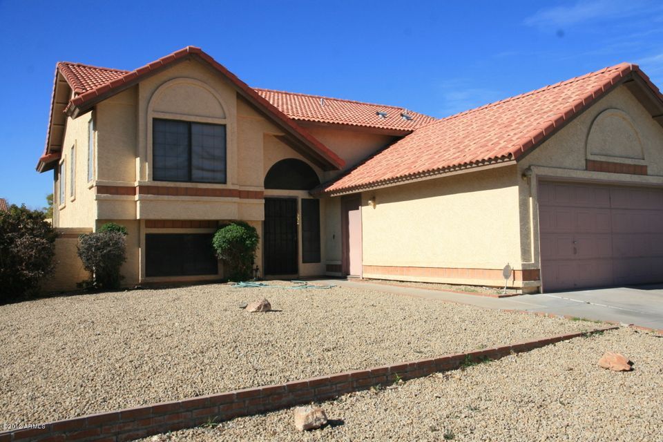
602 N Sunflower Cir
Chandler, AZ 85226
Today
|
Edit
Favorites
480-205-4521
-
Bedrooms
4
-
Bathrooms
3
-
Square Feet
2,288 sq ft
-
Available
Available Dec 14
602 N Sunflower Cir

Favorites
About This Home
$2,000 deposit,
Available Dec 14
Fantastic 4 bedroom 3 bath in the heart of Chandler. New flooring, new paint and window coverings throughout. Right around the corner from the park and minutes from the freeway and shopping.
602 N Sunflower Cir is a house located in Maricopa County and the 85226 ZIP Code. This area is served by the Kyrene Elementary attendance zone.
* Price shown is base rent. Excludes user-selected optional fees and variable or usage-based fees and required charges due at or prior to move-in or at move-out. Price, availability, fees, and any applicable rent special are subject to change without notice.
* Square footage definitions vary. Displayed square footage is approximate.
Fees and Policies
The fees below are based on community-supplied data and may exclude additional fees and utilities.
- One-Time Basics
- Due at Move-In
- Security Deposit - RefundableCharged per unit.$2,000
- Due at Move-In
- Garage Lot
Property Fee Disclaimer: Based on community-supplied data and independent market research. Subject to change without notice. May exclude fees for mandatory or optional services and usage-based utilities.
House Features
Air Conditioning
Dishwasher
Disposal
Range
- Air Conditioning
- Cable Ready
- Dishwasher
- Disposal
- Range
- Yard
Contact
- Listed by Jaime
- Phone Number
- Contact
Location
Get Directions
Amenities
- Air Conditioning
- Cable Ready
- Dishwasher
- Disposal
- Range
- Yard
Situated about four miles west of Downtown Chandler, West Chandler is a scenic suburb brimming with recreation and retail. West Chandler residents enjoy access to an array of local parks, including Desert Breeze Park, Nozomi Park, and Hanger Park, as well as close proximity to the sprawling South Mountain Park.
Retail options in West Chandler provide a host of modern delights and everyday conveniences, with numerous shopping centers and plazas strewn throughout the area in addition to the upscale Chandler Fashion Center. West Chandler is also convenient to the popular Lone Butte Casino. Getting around from West Chandler is easy with access to the Santan Freeway, Maricopa Freeway, and the Price Freeway.
Learn more about living in West Chandler
Education
| Colleges & Universities | Distance | ||
|---|---|---|---|
| Colleges & Universities | Distance | ||
| Drive: | 17 min | 8.6 mi | |
| Drive: | 17 min | 9.2 mi | |
| Drive: | 17 min | 10.2 mi | |
| Drive: | 19 min | 10.6 mi |
602 N Sunflower Cir is within 17 minutes or 8.6 miles from Arizona State University. It is also near Mesa C.C., Southern and Dobson and Alverno College.
Schools


Public Elementary & Middle School
Grades 5-8
615 Students
Attendance Zone
Public Elementary School
Grades PK-5
568 Students
Attendance Zone
Public High School
Grades 9-12
2,733 Students
Attendance Zone
Private Elementary & Middle School
Grades PK-8
332 Students
Nearby
Private Middle & High School
Grades 6-12
Nearby
School data provided by
 The GreatSchools Rating helps parents compare schools within a state based on a variety of school quality indicators and provides a helpful picture of how effectively each school serves all of its students. Ratings are on a scale of 1 (below average) to 10 (above average) and can include test scores, college readiness, academic progress, advanced courses, equity, discipline and attendance data. We also advise parents to visit schools, consider other information on school performance and programs, and consider family needs as part of the school selection process.
View GreatSchools Rating Methodology
Data provided by GreatSchools.org © 2025. All rights reserved.
View GreatSchools Rating Methodology
Data provided by GreatSchools.org © 2025. All rights reserved.
Transportation options available in Chandler include Rural/Apache, located 8.0 miles from 602 N Sunflower Cir. 602 N Sunflower Cir is near Phoenix Sky Harbor International, located 13.0 miles or 21 minutes away, and Phoenix-Mesa Gateway, located 19.0 miles or 28 minutes away.
| Transit / Subway | Distance | ||
|---|---|---|---|
| Transit / Subway | Distance | ||
|
|
Drive: | 16 min | 8.0 mi |
|
|
Drive: | 15 min | 8.0 mi |
|
|
Drive: | 15 min | 8.1 mi |
|
|
Drive: | 16 min | 8.3 mi |
|
|
Drive: | 18 min | 9.2 mi |
| Commuter Rail | Distance | ||
|---|---|---|---|
| Commuter Rail | Distance | ||
|
|
Drive: | 29 min | 20.1 mi |
| Airports | Distance | ||
|---|---|---|---|
| Airports | Distance | ||
|
Phoenix Sky Harbor International
|
Drive: | 21 min | 13.0 mi |
|
Phoenix-Mesa Gateway
|
Drive: | 28 min | 19.0 mi |
Time and distance from 602 N Sunflower Cir.
| Shopping Centers | Distance | ||
|---|---|---|---|
| Shopping Centers | Distance | ||
| Walk: | 10 min | 0.6 mi | |
| Walk: | 13 min | 0.7 mi | |
| Walk: | 16 min | 0.8 mi |
602 N Sunflower Cir has 3 shopping centers within 0.8 mile, which is about a 16-minute walk. The miles and minutes will be for the farthest away property.
| Parks and Recreation | Distance | ||
|---|---|---|---|
| Parks and Recreation | Distance | ||
|
Pecos Park
|
Drive: | 7 min | 3.6 mi |
|
South Mountain Park
|
Drive: | 14 min | 6.2 mi |
|
ASU Center for Meteorite Studies
|
Drive: | 18 min | 8.8 mi |
|
Desert Arboretum Park
|
Drive: | 18 min | 9.0 mi |
|
Camelback Mountain Park
|
Drive: | 27 min | 14.7 mi |
602 N Sunflower Cir has 5 parks within 14.7 miles, including Pecos Park, South Mountain Park, and ASU Center for Meteorite Studies.
| Hospitals | Distance | ||
|---|---|---|---|
| Hospitals | Distance | ||
| Drive: | 8 min | 4.3 mi | |
| Drive: | 8 min | 4.3 mi | |
| Drive: | 9 min | 4.9 mi |
602 N Sunflower Cir has 3 hospitals within 4.9 miles, the nearest is Arizona Orthopedic and Surgical Specialty Hospital which is 4.3 miles away and a 8 minute drive.
| Military Bases | Distance | ||
|---|---|---|---|
| Military Bases | Distance | ||
| Drive: | 20 min | 13.7 mi | |
| Drive: | 50 min | 38.2 mi | |
| Drive: | 97 min | 78.9 mi |
602 N Sunflower Cir has 3 military bases within 78.9 miles, the nearest is Phoenix Sky Harbor Airport Air Guard Station which is 13.7 miles away and a 20 minute drive.
You May Also Like
Similar Rentals Nearby


What Are Walk Score®, Transit Score®, and Bike Score® Ratings?
Walk Score® measures the walkability of any address. Transit Score® measures access to public transit. Bike Score® measures the bikeability of any address.
What is a Sound Score Rating?
A Sound Score Rating aggregates noise caused by vehicle traffic, airplane traffic and local sources

602 N Sunflower Cir
Chandler, AZ 85226