
$6,250
/ Month
588 E Angela St
Pleasanton, CA 94566
Today
Favorites
925-519-2982
-
Bedrooms
4
-
Bathrooms
3
-
Square Feet
2,446 sq ft
-
Available
Available Now
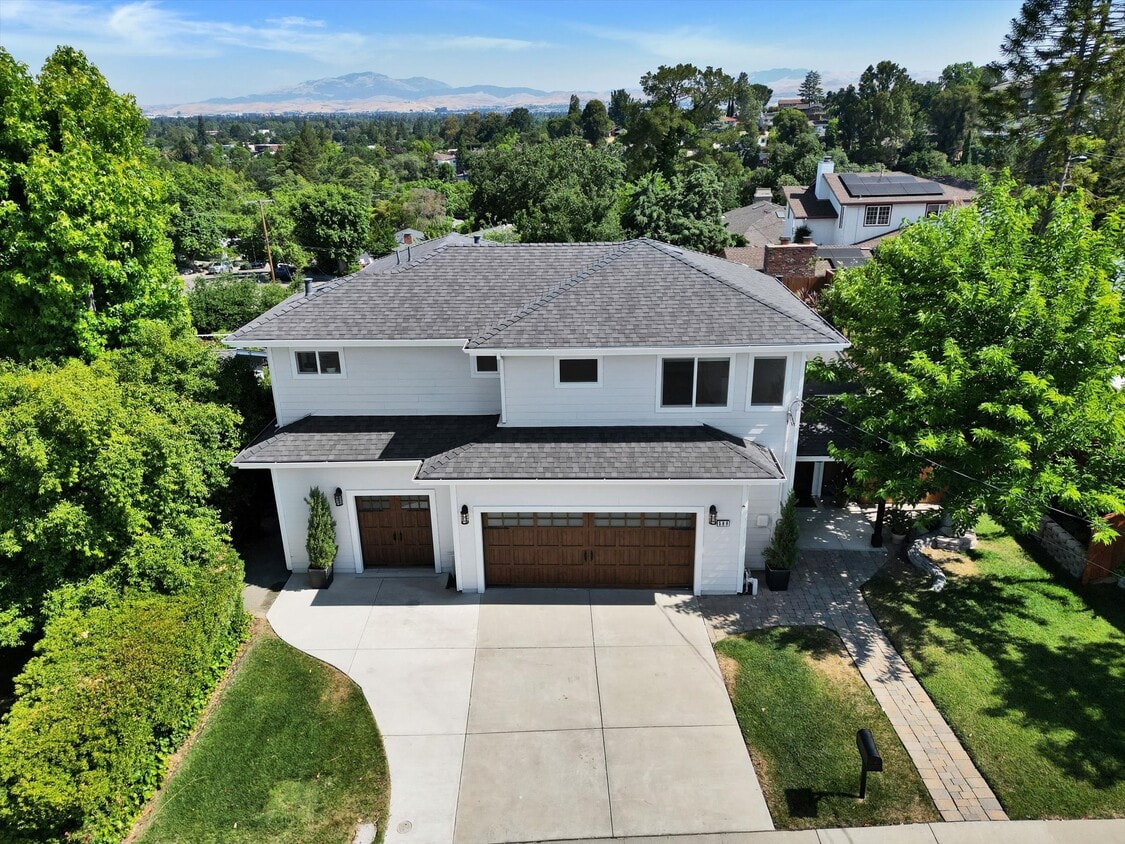
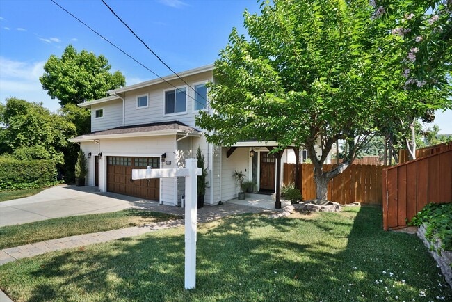
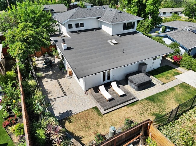
588 E Angela St

Favorites
About This Home
$6,250 deposit,
Available Now
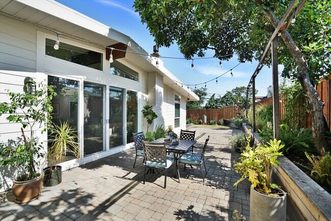
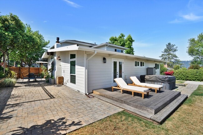
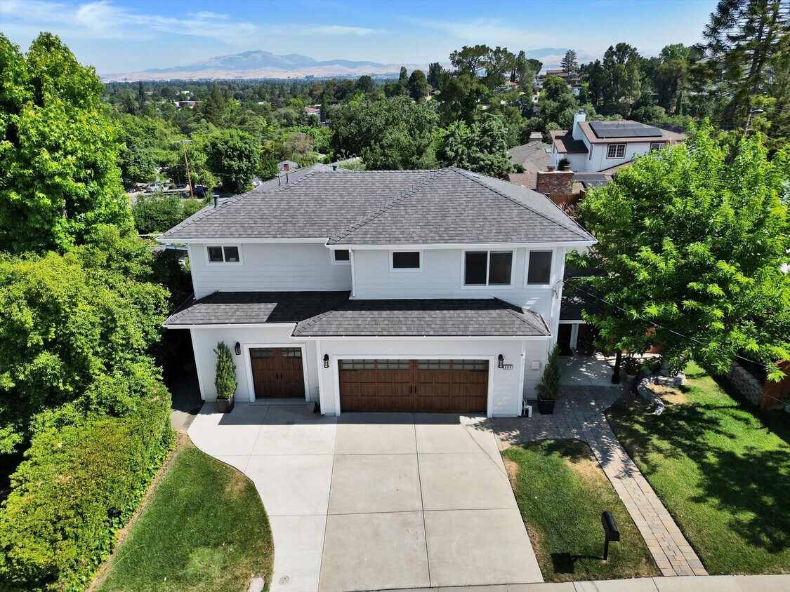
Premium View Lot, Walk to Farmers Market and all that downtown Pleasanton has to offer. The home has been fully renovated and updated, 4 bedroom, 3 bathroom home with loft and 2 1/2 car garage with storage closet, shelves, workbench area and 240V EV outlet. This home has all the amenities: central air, central heat, dishwasher, hardwood floors, stainless steel appliances, new washer and dryer and wine refrigerator. Plenty of room to entertain in the great room with large flat screen TV and sound bar and a gas fireplace, an updated kitchen with chef stove and lots of room including pantry. Large master suite with picture frame views of Mt Diablo, a large master bath and walk in closet upstairs, plus downstairs are 3 additional bedrooms with ample closet space, two newly renovated bathrooms. A fenced yard with patio, deck and lawn area with views of Mt Diablo. Weekly yard maintenance and water included. No other utilities included. Unfurnished. Is small dog friendly. NO smoking. Available now. $6250/month rent. $6250 security deposit required. Application, Income verification and background check required. Please submit the form on this page or contact Vicki & Todd Fiske at to learn more.
588 E Angela St is a house located in Alameda County and the 94566 ZIP Code. This area is served by the Pleasanton Unified attendance zone.
* Price shown is base rent. Excludes user-selected optional fees and variable or usage-based fees and required charges due at or prior to move-in or at move-out. Price, availability, fees, and any applicable rent special are subject to change without notice.
* Square footage definitions vary. Displayed square footage is approximate.
House Features
- Washer/Dryer
- Washer/Dryer Hookup
- Dishwasher
Fees and Policies
The fees below are based on community-supplied data and may exclude additional fees and utilities.
- Dogs Allowed
-
Fees not specified
-
Weight limit--
-
Pet Limit--
Contact
- Listed by Vicki & Todd Fiske
- Phone Number
- Contact
Location
Get Directions
Amenities
- Washer/Dryer
- Washer/Dryer Hookup
- Dishwasher
The cities of Livermore, Dublin and Pleasanton form a loosely shaped triangle within California's Tri-Valley region, a cluster of three small valleys about 33 miles east of San Francisco and 35 miles northeast of San Jose. Known for its Mediterranean climate, rolling hills and historic vineyards, this once bucolic region now boasts three separate downtown areas, a bustling business community and some of the best wineries in the state.
At the eastern end of the region lies the city of Livermore. Once known as Livermores, Livermore Ranch and Nottingham, the city sits at the center of Livermore Valley, a historic region dotted with more than 5,000 acres of mostly family-owned vineyards. A pastoral neighborhood known for its charming yet functional hilltop windmills, Livermore hosts the internationally recognized and sometimes controversial center of scientific research, Lawrence Livermore National Laboratories.
Learn more about living in Dublin/Pleasanton/Livermore
Education
| Colleges & Universities | Distance | ||
|---|---|---|---|
| Colleges & Universities | Distance | ||
| Drive: | 16 min | 8.0 mi | |
| Drive: | 18 min | 8.3 mi | |
| Drive: | 19 min | 11.7 mi | |
| Drive: | 28 min | 17.8 mi |
588 E Angela St is within 16 minutes or 8.0 miles from Las Positas College. It is also near Diablo Valley Coll, San Ramon and Ohlone College, Fremont Campus.
Schools


Public Elementary School
Grades K-5
478 Students
Nearby
Public Elementary School
Grades K-5
641 Students
Attendance Zone
Public Middle School
Grades 6-8
1,050 Students
Attendance Zone
Public High School
Grades 9-12
2,665 Students
Attendance Zone
Private Elementary School
Grades PK-6
Nearby
Private Elementary, Middle & High School
Grades K-12
23 Students
Nearby
School data provided by
 The GreatSchools Rating helps parents compare schools within a state based on a variety of school quality indicators and provides a helpful picture of how effectively each school serves all of its students. Ratings are on a scale of 1 (below average) to 10 (above average) and can include test scores, college readiness, academic progress, advanced courses, equity, discipline and attendance data. We also advise parents to visit schools, consider other information on school performance and programs, and consider family needs as part of the school selection process.
View GreatSchools Rating Methodology
Data provided by GreatSchools.org © 2025. All rights reserved.
View GreatSchools Rating Methodology
Data provided by GreatSchools.org © 2025. All rights reserved.
Transportation options available in Pleasanton include Dublin Pleasanton Station, located 4.5 miles from 588 E Angela St. 588 E Angela St is near Metro Oakland International, located 24.2 miles or 33 minutes away, and Norman Y Mineta San Jose International, located 26.7 miles or 36 minutes away.
| Transit / Subway | Distance | ||
|---|---|---|---|
| Transit / Subway | Distance | ||
|
|
Drive: | 10 min | 4.5 mi |
|
|
Drive: | 10 min | 5.7 mi |
|
|
Drive: | 23 min | 14.1 mi |
|
|
Drive: | 23 min | 14.2 mi |
|
|
Drive: | 29 min | 16.0 mi |
| Commuter Rail | Distance | ||
|---|---|---|---|
| Commuter Rail | Distance | ||
| Drive: | 3 min | 1.1 mi | |
| Drive: | 4 min | 1.2 mi | |
| Drive: | 12 min | 6.8 mi | |
| Drive: | 13 min | 6.9 mi | |
| Drive: | 19 min | 10.2 mi |
| Airports | Distance | ||
|---|---|---|---|
| Airports | Distance | ||
|
Metro Oakland International
|
Drive: | 33 min | 24.2 mi |
|
Norman Y Mineta San Jose International
|
Drive: | 36 min | 26.7 mi |
Time and distance from 588 E Angela St.
| Shopping Centers | Distance | ||
|---|---|---|---|
| Shopping Centers | Distance | ||
| Walk: | 13 min | 0.7 mi | |
| Walk: | 16 min | 0.8 mi | |
| Walk: | 19 min | 1.0 mi |
588 E Angela St has 3 shopping centers within 1.0 mile, which is about a 19-minute walk. The miles and minutes will be for the farthest away property.
| Parks and Recreation | Distance | ||
|---|---|---|---|
| Parks and Recreation | Distance | ||
|
Shadow Cliffs Regional Recreation Area
|
Drive: | 8 min | 2.7 mi |
|
Dublin Hills Regional Parks
|
Drive: | 20 min | 8.6 mi |
|
Niles Canyon Railway
|
Drive: | 23 min | 13.1 mi |
|
Pleasanton Ridge Regional Park
|
Drive: | 23 min | 14.8 mi |
|
Garin/Dry Creek Pioneer Parks
|
Drive: | 29 min | 16.5 mi |
588 E Angela St has 5 parks within 16.5 miles, including Shadow Cliffs Regional Recreation Area, Dublin Hills Regional Parks, and Pleasanton Ridge Regional Park.
| Hospitals | Distance | ||
|---|---|---|---|
| Hospitals | Distance | ||
| Drive: | 7 min | 2.9 mi | |
| Drive: | 19 min | 12.3 mi | |
| Drive: | 23 min | 14.5 mi |
588 E Angela St has 3 hospitals within 14.5 miles, the nearest is Stanford Health Care - ValleyCare which is 2.9 miles away and a 7 minute drive.
| Military Bases | Distance | ||
|---|---|---|---|
| Military Bases | Distance | ||
| Drive: | 41 min | 29.4 mi |
588 E Angela St is 29.4 miles and a 41 minute drive from Ames Research Center.
You May Also Like
Similar Rentals Nearby


What Are Walk Score®, Transit Score®, and Bike Score® Ratings?
Walk Score® measures the walkability of any address. Transit Score® measures access to public transit. Bike Score® measures the bikeability of any address.
What is a Sound Score Rating?
A Sound Score Rating aggregates noise caused by vehicle traffic, airplane traffic and local sources
588 E Angela St
Pleasanton, CA 94566