1 / 26


| Beds | Baths | Average SF |
|---|---|---|
| 2 Bedrooms 2 Bedrooms 2 Br | 2 Baths 2 Baths 2 Ba | 1,886 SF |
The fees listed below are community-provided and may exclude utilities or add-ons. All payments are made directly to the property and are non-refundable unless otherwise specified.
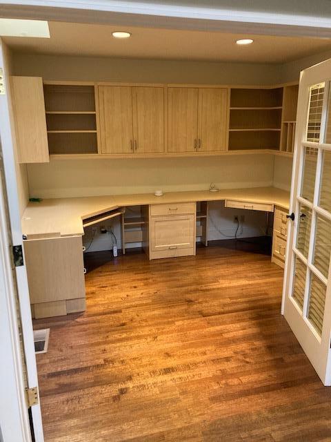
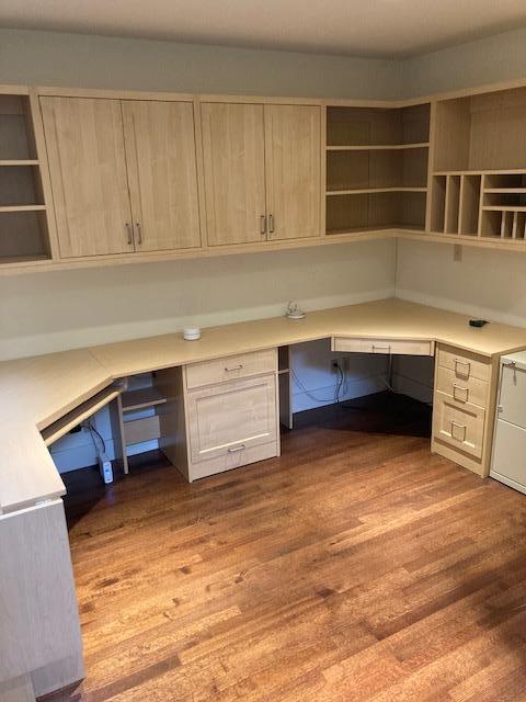
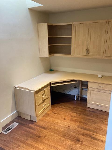
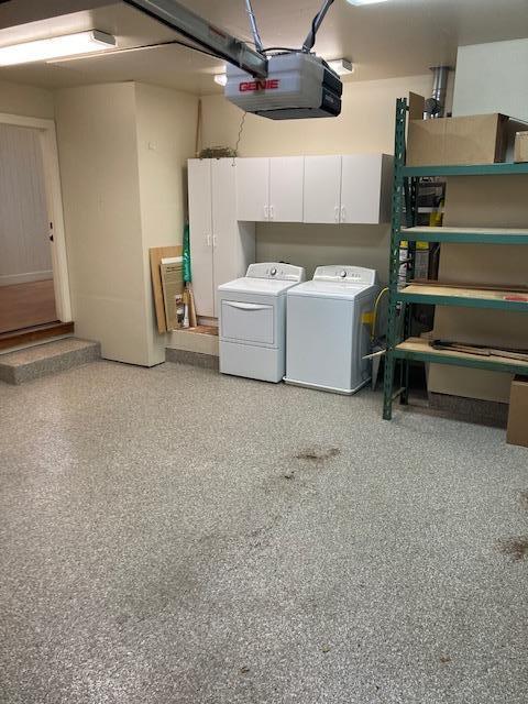
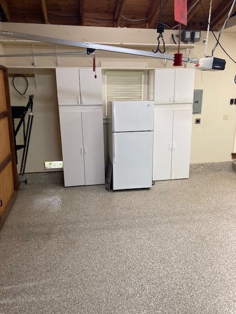
Exceptional home in the heart of Old Los Altos just blocks to downtown, parks and so much more. Located on a highly coveted street, this property offers 2 bedrooms and 2 bathrooms with an office or a 3rd bedroom. Spacious open floor plan with vaulted ceilings and many skylights which bring in a lot of natural light. A lovely master suite with french doors that lead to the private and quiet backyard. Other features include hardwood flooring, custom cabinetry throughout, and attached two car garage. Outstanding location with Los Altos Schools.
586 Orange Ave is a house located in Santa Clara County and the 94022 ZIP Code. This area is served by the Los Altos Elementary School District attendance zone.
Apricot orchards once blanketed the land where Los Altos now sits, and that quiet, unhurried character still shapes the city today. Tucked along the western edge of Silicon Valley in Santa Clara County, this small city spans just seven square miles yet packs in tree-lined streets, well-kept parks, and a genuinely walkable downtown along Main Street. Nearby Palo Alto and Mountain View are just minutes away, putting the best of the South Bay right at your doorstep without sacrificing the calm of a close-knit residential community. Redwood Grove Nature Preserve offers a shady escape when the pace of life calls for a reset.
The rental market here reflects the city's polished, residential feel. Apartment communities tend toward thoughtfully designed mid-size buildings and garden-style layouts, with townhomes also available for those wanting more space.
Learn more about living in Los Altos| Colleges & Universities | Distance | ||
|---|---|---|---|
| Colleges & Universities | Distance | ||
| Drive: | 5 min | 1.6 mi | |
| Drive: | 10 min | 3.8 mi | |
| Drive: | 13 min | 5.6 mi | |
| Drive: | 13 min | 7.0 mi |


Transportation options available in Los Altos include Whisman Station, located 4.7 miles from 586 Orange Ave. 586 Orange Ave is near Norman Y Mineta San Jose International, located 12.5 miles or 23 minutes away, and San Francisco International, located 26.5 miles or 38 minutes away.
| Transit / Subway | Distance | ||
|---|---|---|---|
| Transit / Subway | Distance | ||
|
|
Drive: | 13 min | 4.7 mi |
| Drive: | 10 min | 4.7 mi | |
|
|
Drive: | 12 min | 5.0 mi |
| Drive: | 14 min | 6.7 mi | |
| Drive: | 15 min | 6.7 mi |
| Commuter Rail | Distance | ||
|---|---|---|---|
| Commuter Rail | Distance | ||
| Drive: | 7 min | 3.1 mi | |
| Drive: | 10 min | 3.6 mi | |
| Drive: | 12 min | 5.5 mi | |
| Drive: | 15 min | 5.8 mi | |
| Drive: | 16 min | 7.1 mi |
| Airports | Distance | ||
|---|---|---|---|
| Airports | Distance | ||
|
Norman Y Mineta San Jose International
|
Drive: | 23 min | 12.5 mi |
|
San Francisco International
|
Drive: | 38 min | 26.5 mi |
Scores provided by
Traffic
-Airport
-Businesses
-Scores provided by
HowLoud What is a Sound Score Rating? A Sound Score Rating aggregates noise caused by vehicle traffic, airplane traffic and local sources. How It WorksTime and distance from 586 Orange Ave.
| Shopping Centers | Distance | ||
|---|---|---|---|
| Shopping Centers | Distance | ||
| Drive: | 5 min | 1.8 mi | |
| Drive: | 7 min | 2.2 mi | |
| Drive: | 6 min | 2.3 mi |
| Parks and Recreation | Distance | ||
|---|---|---|---|
| Parks and Recreation | Distance | ||
|
Redwood Grove
|
Walk: | 5 min | 0.3 mi |
|
Foothill College Observatory
|
Drive: | 6 min | 1.8 mi |
|
Terman Park
|
Drive: | 7 min | 2.9 mi |
|
Esther Clark Nature Preserve
|
Drive: | 6 min | 2.9 mi |
|
Byrne Preserve
|
Drive: | 8 min | 3.2 mi |
| Hospitals | Distance | ||
|---|---|---|---|
| Hospitals | Distance | ||
| Drive: | 8 min | 2.8 mi | |
| Drive: | 14 min | 6.4 mi | |
| Drive: | 15 min | 6.6 mi |
| Military Bases | Distance | ||
|---|---|---|---|
| Military Bases | Distance | ||
| Drive: | 17 min | 7.0 mi | |
| Drive: | 63 min | 42.7 mi | |
| Drive: | 63 min | 42.9 mi |


What Are Walk Score®, Transit Score®, and Bike Score® Ratings?
Walk Score® measures the walkability of any address. Transit Score® measures access to public transit. Bike Score® measures the bikeability of any address.
What is a Sound Score Rating?
A Sound Score Rating aggregates noise caused by vehicle traffic, airplane traffic and local sources.

586 Orange Ave
Los Altos, CA 94022