
$1,900
/ Month
58 Avenue 64
Pasadena, CA 91105
2 Weeks Ago
Favorites
58 Avenue 64

Favorites
Check Back Soon for Upcoming Availability
| Beds | Baths | Average SF |
|---|---|---|
| 2 Bedrooms 2 Bedrooms 2 Br | 1 Bath 1 Bath 1 Ba | 800 SF |
Fees and Policies
The fees below are based on community-supplied data and may exclude additional fees and utilities.
- Parking
-
Garage--
Details
Utilities Included
-
Water
-
Trash Removal
Lease Options
-
12 Months
About This Property
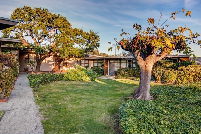
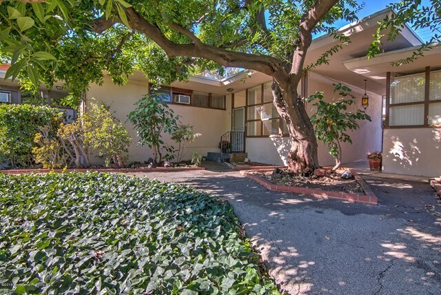
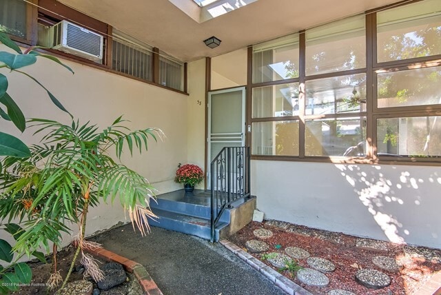
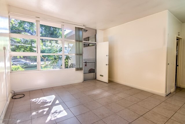
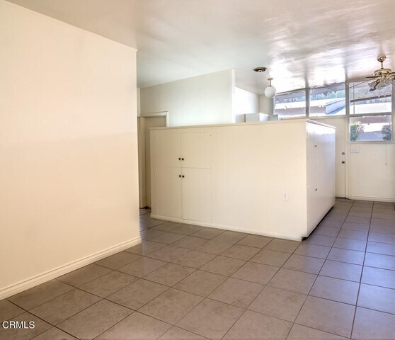
Well maintained 1949 Midcentury Modern condo in one of Pasadena's favorite neighborhoods. One level condo in 6 unit garden complex adjacent to San Rafael, w/ its own patio and 1 car garage. Meticulously maintained original kitchen & period inspired bathrm. All of the original architectural charm remains, has been enhanced & has never looked better. Wonderful natural lighting throughout the unit. A large patio off the kitchen for BBQing and entertaining. You also have laundry in the complex. The location could not get any better with Little Flower Company, Stoney Point, Kitchen for Exploring Foods and much more within a block.
58 Avenue 64 is a condo located in Los Angeles County and the 91105 ZIP Code. This area is served by the Pasadena Unified attendance zone.
Condo Features
Air Conditioning
Tile Floors
Heating
Range
- Air Conditioning
- Heating
- Range
- Tile Floors
- Laundry Facilities
- Patio
Location
Get Directions
Annandale is nestled in a quaint, high-end section of Pasadena in the outskirts of Los Angeles. Many visitors pass through Annandale to cross the landmark Colorado Street Bridge or exit the Ventura Freeway heading to events at the Rose Bowl. The neighborhood contains mostly million-dollar homes and grand estates, along with a few upscale rental properties. The only commercial zone rests along Colorado Boulevard, comprising of a few small businesses. The Arroyo Seco defines the eastern border, a dry riverbed that extends from the San Gabriel Mountains down to Elysian Park. Annandale sits only two miles west of Pasadena City Hall and nine miles northeast of Downtown Los Angeles.
Learn more about living in AnnandaleBelow are rent ranges for similar nearby apartments
Amenities
- Air Conditioning
- Heating
- Range
- Tile Floors
- Laundry Facilities
- Patio
Expenses
Utilities Included
Water, Trash Removal
Included
Education
| Colleges & Universities | Distance | ||
|---|---|---|---|
| Colleges & Universities | Distance | ||
| Drive: | 5 min | 2.9 mi | |
| Drive: | 7 min | 3.3 mi | |
| Drive: | 6 min | 3.4 mi | |
| Drive: | 8 min | 3.4 mi |
58 Avenue 64 is within 7 minutes or 3.3 miles from Occidental College. It is also near Art Center College of Design and Fuller Theological Seminary.
Schools

Charter Elementary School
Grades K-5
75 Students
Nearby
Public Elementary School
Grades K-5
385 Students
Attendance Zone
Public Middle & High School
Grades 6-12
1,117 Students
Attendance Zone
Private Elementary & Middle School
Grades PK-8
237 Students
Nearby
Private Elementary, Middle & High School
Grades 1-12
71 Students
Nearby
Private Middle & High School
Grades 6-12
Nearby
School data provided by
 The GreatSchools Rating helps parents compare schools within a state based on a variety of school quality indicators and provides a helpful picture of how effectively each school serves all of its students. Ratings are on a scale of 1 (below average) to 10 (above average) and can include test scores, college readiness, academic progress, advanced courses, equity, discipline and attendance data. We also advise parents to visit schools, consider other information on school performance and programs, and consider family needs as part of the school selection process.
View GreatSchools Rating Methodology
Data provided by GreatSchools.org © 2025. All rights reserved.
View GreatSchools Rating Methodology
Data provided by GreatSchools.org © 2025. All rights reserved.
Transportation options available in Pasadena include Memorial Park Station, located 2.2 miles from 58 Avenue 64. 58 Avenue 64 is near Bob Hope, located 15.1 miles or 21 minutes away, and Los Angeles International, located 22.9 miles or 37 minutes away.
| Transit / Subway | Distance | ||
|---|---|---|---|
| Transit / Subway | Distance | ||
|
|
Drive: | 4 min | 2.2 mi |
|
|
Drive: | 4 min | 2.2 mi |
|
|
Drive: | 6 min | 2.8 mi |
|
|
Drive: | 5 min | 2.8 mi |
|
|
Drive: | 7 min | 3.6 mi |
| Commuter Rail | Distance | ||
|---|---|---|---|
| Commuter Rail | Distance | ||
|
|
Drive: | 11 min | 7.6 mi |
|
|
Drive: | 15 min | 7.8 mi |
|
|
Drive: | 16 min | 7.9 mi |
|
|
Drive: | 13 min | 9.7 mi |
| Drive: | 18 min | 11.9 mi |
| Airports | Distance | ||
|---|---|---|---|
| Airports | Distance | ||
|
Bob Hope
|
Drive: | 21 min | 15.1 mi |
|
Los Angeles International
|
Drive: | 37 min | 22.9 mi |
Time and distance from 58 Avenue 64.
| Shopping Centers | Distance | ||
|---|---|---|---|
| Shopping Centers | Distance | ||
| Drive: | 2 min | 1.4 mi | |
| Drive: | 2 min | 1.7 mi | |
| Drive: | 3 min | 1.8 mi |
58 Avenue 64 has 3 shopping centers within 1.8 miles, which is about a 3-minute drive. The miles and minutes will be for the farthest away property.
| Parks and Recreation | Distance | ||
|---|---|---|---|
| Parks and Recreation | Distance | ||
|
Kidspace Children's Museum
|
Drive: | 4 min | 2.0 mi |
|
Audubon Center at Debs Park
|
Drive: | 8 min | 3.9 mi |
|
Jet Propulsion Laboratory
|
Drive: | 7 min | 4.6 mi |
|
Huntington Botanical Gardens
|
Drive: | 11 min | 5.2 mi |
|
Elyria Canyon Park
|
Drive: | 12 min | 5.7 mi |
58 Avenue 64 has 5 parks within 5.7 miles, including Kidspace Children's Museum, Jet Propulsion Laboratory, and Audubon Center at Debs Park.
| Hospitals | Distance | ||
|---|---|---|---|
| Hospitals | Distance | ||
| Drive: | 4 min | 2.6 mi | |
| Drive: | 7 min | 4.2 mi | |
| Drive: | 12 min | 6.0 mi |
58 Avenue 64 has 3 hospitals within 6.0 miles, the nearest is Huntington Memorial Hospital which is 2.6 miles away and a 4 minute drive.
| Military Bases | Distance | ||
|---|---|---|---|
| Military Bases | Distance | ||
| Drive: | 34 min | 24.5 mi | |
| Drive: | 47 min | 31.9 mi |
58 Avenue 64 is 24.5 miles from Los Angeles Air Force Base, and is convenient to other military bases, including Los Alamitos Army Airfield.
You May Also Like
Similar Rentals Nearby
-
-

-

-

-

-

-

-

-
1 / 36

-
1 / 43

What Are Walk Score®, Transit Score®, and Bike Score® Ratings?
Walk Score® measures the walkability of any address. Transit Score® measures access to public transit. Bike Score® measures the bikeability of any address.
What is a Sound Score Rating?
A Sound Score Rating aggregates noise caused by vehicle traffic, airplane traffic and local sources

58 Avenue 64
Pasadena, CA 91105