-
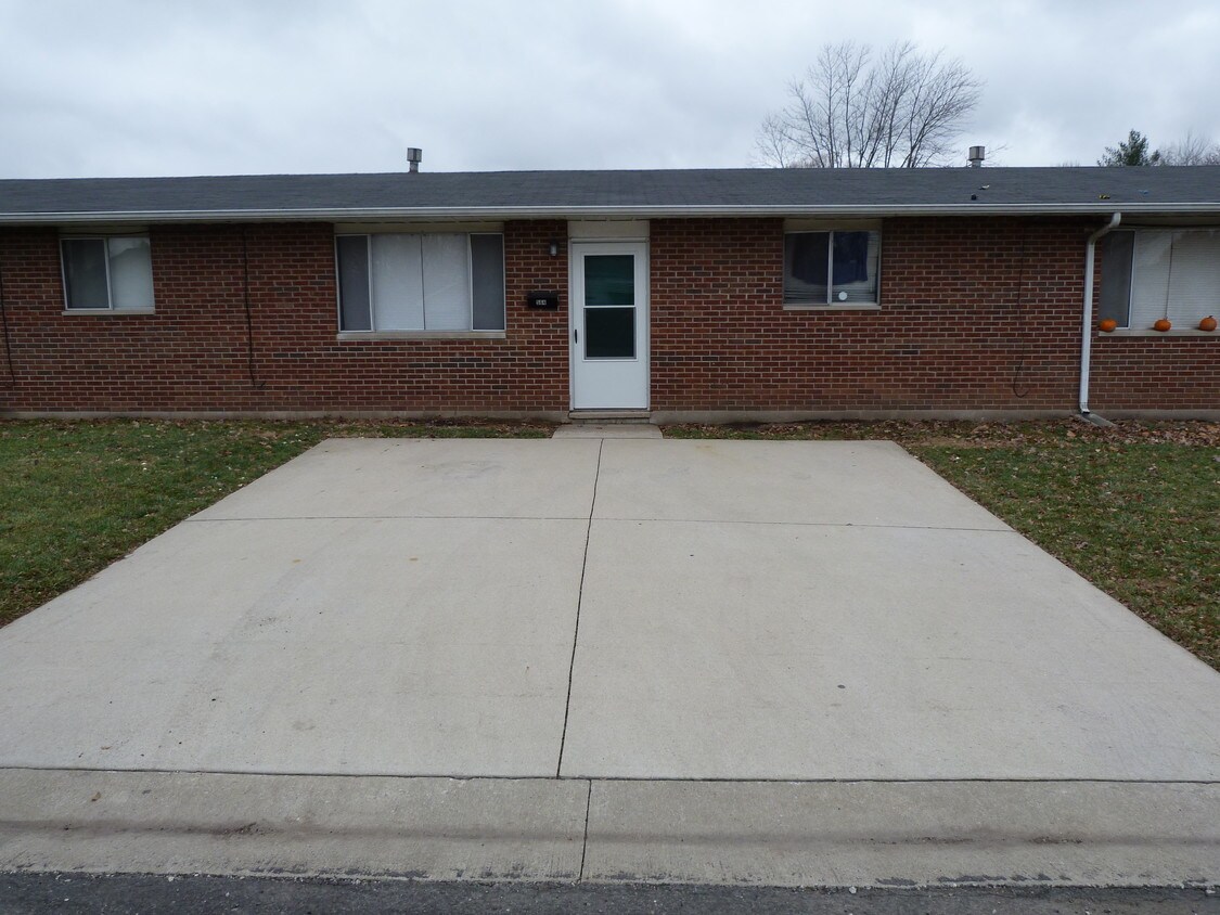
front with 2 private parking spots
564 Sheridan St
564 Sheridan St,
Bethalto,
IL
62010
2 Weeks Ago
Favorites
564 Sheridan St

Favorites
Check Back Soon for Upcoming Availability
Fees and Policies
The fees below are based on community-supplied data and may exclude additional fees and utilities.
- Parking
-
Surface Lot--
Details
Lease Options
-
12 Months
Property Information
-
Furnished Units Available
About 564 Sheridan St Bethalto, IL 62010
Newly renovated 2bed/1bth ground level apartment, new items include shower, vanity, water heater, stove vent hood, all curtains, kitchen ceiling fan, electric breaker panel. Including all items central cooling & heat, washer & dryer, fridge, gas stove, gas water heat. Dimensions as follows lv room 17x11, kitchen 12x11, bath 5x8 & 2x2 closet in bathroom, hall 4x7, bedroom 12x9, bedroom 11x11, both bedrooms have ceiling fans & closets 5x2. concrete pad out back 8x8. Rent is $530 month and a 1 year lease + $530 deposit. Unit is NO PETS/NON SMOKING. Available NOW TO VIEW!
564 Sheridan St is an apartment community located in Madison County and the 62010 ZIP Code.
Apartment Features
Washer/Dryer
Ceiling Fans
Smoke Free
Furnished
- Washer/Dryer
- Ceiling Fans
- Smoke Free
- Wheelchair Accessible (Rooms)
- Kitchen
- Furnished
Location
Get Directions
Travel from Saint Louis, Missouri northeast along I-255 for roughly 26 miles and you’ll find the cozy suburb of Bethalto, Illinois. Bethalto dates back to 1804 when the first settler, Thomas Rattan, arrived. Soon, more settlers moved in. Originally Rattan’s Prairie, the name was changed to Bethel in 1834, the same name as a nearby church. When the village established a post office, they realized there was already a Bethel, Illinois, so they got creative. They borrowed letters of the neighboring town, Alton, and merged them with Bethel. Learn more about Bethalto’s history at the Bethalto Historical Museum, located in the original village hall built in 1873.
South of Bethalto Drive, much of the village is given to the St. Louis Regional Airport. The north side contains beautiful neighborhoods, a variety of shops, historic buildings along Main Street, Bethalto Park, and the Bethalto Arboretum. Bethalto Park includes a splash pad, a playground, and picnic areas.
Learn more about living in Bethalto
Amenities
- Washer/Dryer
- Ceiling Fans
- Smoke Free
- Wheelchair Accessible (Rooms)
- Kitchen
- Furnished
Education
| Colleges & Universities | Distance | ||
|---|---|---|---|
| Colleges & Universities | Distance | ||
| Drive: | 20 min | 12.0 mi | |
| Drive: | 18 min | 12.4 mi | |
| Drive: | 23 min | 15.6 mi | |
| Drive: | 38 min | 24.7 mi |
564 Sheridan St is within 20 minutes or 12.0 miles from SIU Edwardsville. It is also near Lewis and Clark Comm. Coll. and SW Illinois Coll., Wolf Campus.
You May Also Like
Similar Rentals Nearby


What Are Walk Score®, Transit Score®, and Bike Score® Ratings?
Walk Score® measures the walkability of any address. Transit Score® measures access to public transit. Bike Score® measures the bikeability of any address.
What is a Sound Score Rating?
A Sound Score Rating aggregates noise caused by vehicle traffic, airplane traffic and local sources