
$6,900 / Month
541 Cecelia Ct
Los Altos, CA 94022
2 Weeks Ago
Favorites
541 Cecelia Ct

Favorites
Check Back Soon for Upcoming Availability
| Beds | Baths | Average SF |
|---|---|---|
| 3 Bedrooms 3 Bedrooms 3 Br | 2 Baths 2 Baths 2 Ba | 2,428 SF |
About This Property
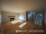
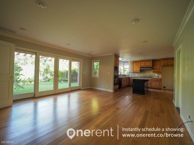
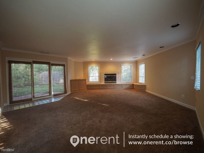
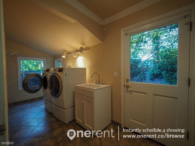
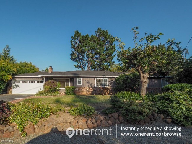
(408) 917-0430 - MOVE-IN READY! Fall in love with this gorgeous home that accentuates an elegant 3 bedrooms and 2 bathrooms with hardwood and carpeted floor. It is situated in the North Los Altos neighborhood in a unique community offering both privacy and a great neighborhood feel. Its gorgeous landscaped front yard adds brightness to this property. The beautiful kitchen has granite counters and good cabinetry for ample storage. It is equipped with range/oven, microwave, dishwasher, and garbage disposal. The stunning bathrooms upstairs with a large walk-in shower, double vanity, and a soaking tub you will surely get fond of. Worry no more for your laundry as it has an in-unit of washer and dryer. For additional storage, the backyard has two storage sheds where one shed has been converted into a play room. This home is close to Almond Elementary School and Los Altos High School. Get a breath of fresh air in the nearby parks of Redwood Grove Nature Preserve, Shoup Park, and Lincoln Park. So what are you waiting for? Apply now and fall in love with this home like you never had been before! No Pets Allowed (RLNE3514243) Other Amenities - Other- Other Amenities: Additional Storage: Two storage sheds in the back yards, one shed has been converted into a play room.. Appliances - Dishwasher, Washer & Dryer- Washer and Dryer Facility: In-Unit, Other- Other Appliances: Garbage disposal, Range / Oven, Washer and dryer, Microwave. Details regarding this property's Utilities - Resident Pays Electricity, Resident Pays Gas, Resident Pays Water, Other- Other Utilities: Sewage, Garbage, Internet, Cable, Gardening service. Pet policies - No Pets Allowed.
541 Cecelia Ct is a house located in Santa Clara County and the 94022 ZIP Code. This area is served by the Los Altos Elementary attendance zone.
Location
Get Directions
North Los Altos contains the city’s vibrant commercial centers. The many shops and eateries of Main Street are in the southern portion of North Los Altos, while the diverse restaurants and cafes of San Antonio Road are in the northern stretches near San Antonio Center.
Outside of these commercial areas, North Los Altos is predominantly residential, offering an array of apartments available for rent along tree-lined avenues. Many of the rentals in North Los Altos feature stunning mountain views, as well as close proximity to Mountain View, Foothill College, Stanford University, and Palo Alto. Getting around from North Los Altos is simple with access to El Camino Real, Interstate 280, and San Antonio Station.
Learn more about living in North Los AltosBelow are rent ranges for similar nearby apartments
Education
| Colleges & Universities | Distance | ||
|---|---|---|---|
| Colleges & Universities | Distance | ||
| Drive: | 8 min | 2.7 mi | |
| Drive: | 9 min | 3.6 mi | |
| Drive: | 13 min | 5.1 mi | |
| Drive: | 14 min | 7.3 mi |
541 Cecelia Ct is within 8 minutes or 2.7 miles from Foothill College, Middlefield. It is also near Foothill Coll., Los Altos and Stanford University.
Schools

Public Elementary School
Grades K-5
367 Students
Nearby
Public Elementary School
Grades K-6
353 Students
Attendance Zone
Public Middle School
Grades 7-8
497 Students
Attendance Zone
Public High School
Grades 9-12
2,141 Students
Attendance Zone
Private Elementary & Middle School
Grades PK-8
188 Students
Nearby
Private Elementary School
Grades K-6
80 Students
Nearby
Private Elementary & Middle School
Grades 1-8
136 Students
Nearby
Private Middle & High School
Grades 6-12
140 Students
Nearby
School data provided by
 The GreatSchools Rating helps parents compare schools within a state based on a variety of school quality indicators and provides a helpful picture of how effectively each school serves all of its students. Ratings are on a scale of 1 (below average) to 10 (above average) and can include test scores, college readiness, academic progress, advanced courses, equity, discipline and attendance data. We also advise parents to visit schools, consider other information on school performance and programs, and consider family needs as part of the school selection process.
View GreatSchools Rating Methodology
Data provided by GreatSchools.org © 2025. All rights reserved.
View GreatSchools Rating Methodology
Data provided by GreatSchools.org © 2025. All rights reserved.
Transportation options available in Los Altos include Mountain View Station, located 2.3 miles from 541 Cecelia Ct. 541 Cecelia Ct is near Norman Y Mineta San Jose International, located 11.6 miles or 19 minutes away, and San Francisco International, located 25.3 miles or 35 minutes away.
| Transit / Subway | Distance | ||
|---|---|---|---|
| Transit / Subway | Distance | ||
| Drive: | 5 min | 2.3 mi | |
|
|
Drive: | 5 min | 2.3 mi |
| Drive: | 8 min | 3.6 mi | |
| Drive: | 8 min | 3.6 mi | |
| Drive: | 9 min | 4.1 mi |
| Commuter Rail | Distance | ||
|---|---|---|---|
| Commuter Rail | Distance | ||
| Drive: | 4 min | 1.7 mi | |
| Drive: | 6 min | 2.2 mi | |
| Drive: | 7 min | 2.4 mi | |
| Drive: | 10 min | 3.9 mi | |
| Drive: | 10 min | 4.5 mi |
| Airports | Distance | ||
|---|---|---|---|
| Airports | Distance | ||
|
Norman Y Mineta San Jose International
|
Drive: | 19 min | 11.6 mi |
|
San Francisco International
|
Drive: | 35 min | 25.3 mi |
Time and distance from 541 Cecelia Ct.
| Shopping Centers | Distance | ||
|---|---|---|---|
| Shopping Centers | Distance | ||
| Walk: | 10 min | 0.5 mi | |
| Walk: | 13 min | 0.7 mi | |
| Walk: | 18 min | 1.0 mi |
541 Cecelia Ct has 3 shopping centers within 1.0 mile, which is about a 18-minute walk. The miles and minutes will be for the farthest away property.
| Parks and Recreation | Distance | ||
|---|---|---|---|
| Parks and Recreation | Distance | ||
|
Redwood Grove
|
Drive: | 7 min | 2.5 mi |
|
Terman Park
|
Drive: | 7 min | 2.7 mi |
|
J. Pearce Mitchell Park
|
Drive: | 10 min | 3.3 mi |
|
Bol Park
|
Drive: | 9 min | 3.5 mi |
|
Esther Clark Nature Preserve
|
Drive: | 9 min | 3.9 mi |
541 Cecelia Ct has 5 parks within 3.9 miles, including Redwood Grove, Terman Park, and J. Pearce Mitchell Park.
| Hospitals | Distance | ||
|---|---|---|---|
| Hospitals | Distance | ||
| Drive: | 7 min | 2.9 mi | |
| Drive: | 15 min | 5.8 mi | |
| Drive: | 16 min | 6.3 mi |
541 Cecelia Ct has 3 hospitals within 6.3 miles, the nearest is El Camino Hospital which is 2.9 miles away and a 7 minute drive.
| Military Bases | Distance | ||
|---|---|---|---|
| Military Bases | Distance | ||
| Drive: | 12 min | 4.6 mi |
541 Cecelia Ct is 4.6 miles and a 12 minute drive from Ames Research Center.
You May Also Like
Similar Rentals Nearby


What Are Walk Score®, Transit Score®, and Bike Score® Ratings?
Walk Score® measures the walkability of any address. Transit Score® measures access to public transit. Bike Score® measures the bikeability of any address.
What is a Sound Score Rating?
A Sound Score Rating aggregates noise caused by vehicle traffic, airplane traffic and local sources

541 Cecelia Ct
Los Altos, CA 94022