

$4,500 / Month
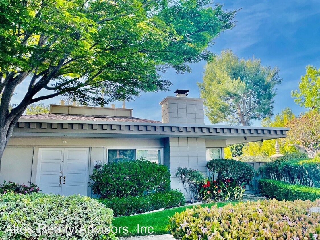
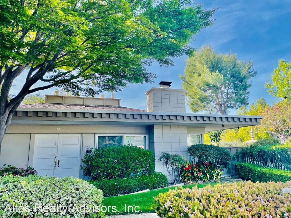
54 Los Altos Square
Los Altos, CA 94022
2 Weeks Ago
Favorites
54 Los Altos Square

Favorites
Check Back Soon for Upcoming Availability
| Beds | Baths | Average SF |
|---|---|---|
| 2 Bedrooms 2 Bedrooms 2 Br | 2 Baths 2 Baths 2 Ba | 1,440 SF |
Fees and Policies
The fees below are based on community-supplied data and may exclude additional fees and utilities.
About This Property
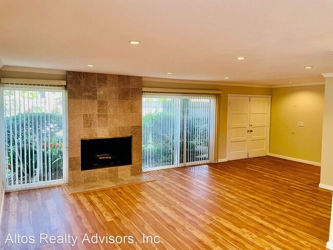
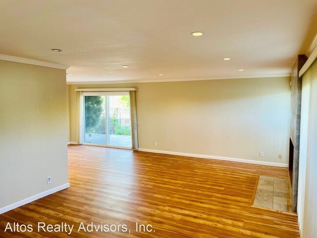
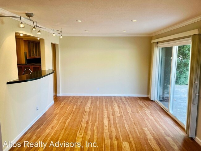
(408) 720-0920 x101 - Beautifully Remodeled 2 Bed 2 Bath Los Altos Townhouse W/ Private Patio + Bonus Study - Los Altos Schools! - This spacious, beautifully remodeled townhouse features 1,440 square feet of living space in a well-kept community. This townhouse was recently completely remodeled with new granite counters in the kitchen, new appliances, two completely remodeled bathrooms, new floors and more. Spacious living room with wood-burning fireplace. Large bedrooms and closets. Bonus study nook with storage. Large private patio overlooking the swimming pool. Mature fruit trees including fig, mandarin, pomegranate, grape & blackberry. Complex Features: gated complex near El Camino and San Antonio. Directly behind Whole Foods Market. A short distance to many shops and restaurants including the San Antonio Shopping Area, Trader Joe's, Safeway, Walmart and Target. Beautifully landscaped and maintained complex. 3 swimming pools, newly renovated clubhouse sauna rooms and game room. Parking -2-Car Detached Garage Pets -No Pets Laundry -Full Sized Washer & Dryer Included HVAC -Radiant Heating -No Air Conditioning Utilities -Owner Pays Garbage, Water & Sewer -Tenant Pays PG&E Schools(*Tenants to Verify*) -Almond Elementary -Egan Junior High -Los Altos High No Pets Allowed (RLNE6127092) Pet policies: No Dogs Allowed, No Cats Allowed.
54 Los Altos Square is a house located in Santa Clara County and the 94022 ZIP Code. This area is served by the Los Altos Elementary attendance zone.
Unique Features
- No Dogs Allowed, No Cats Allowed
Location
Get Directions
North Los Altos contains the city’s vibrant commercial centers. The many shops and eateries of Main Street are in the southern portion of North Los Altos, while the diverse restaurants and cafes of San Antonio Road are in the northern stretches near San Antonio Center.
Outside of these commercial areas, North Los Altos is predominantly residential, offering an array of apartments available for rent along tree-lined avenues. Many of the rentals in North Los Altos feature stunning mountain views, as well as close proximity to Mountain View, Foothill College, Stanford University, and Palo Alto. Getting around from North Los Altos is simple with access to El Camino Real, Interstate 280, and San Antonio Station.
Learn more about living in North Los AltosBelow are rent ranges for similar nearby apartments
| Beds | Average Size | Lowest | Typical | Premium |
|---|---|---|---|---|
| Studio Studio Studio | 482 Sq Ft | $2,125 | $3,376 | $10,170 |
| 1 Bed 1 Bed 1 Bed | 760-764 Sq Ft | $2,410 | $3,655 | $5,931 |
| 2 Beds 2 Beds 2 Beds | 1144-1151 Sq Ft | $3,295 | $4,889 | $7,282 |
| 3 Beds 3 Beds 3 Beds | 1468 Sq Ft | $4,441 | $5,479 | $7,300 |
| 4 Beds 4 Beds 4 Beds | 2608 Sq Ft | $5,270 | $10,192 | $15,000 |
Amenities
- No Dogs Allowed, No Cats Allowed
Education
| Colleges & Universities | Distance | ||
|---|---|---|---|
| Colleges & Universities | Distance | ||
| Drive: | 6 min | 2.1 mi | |
| Drive: | 9 min | 3.5 mi | |
| Drive: | 12 min | 4.6 mi | |
| Drive: | 17 min | 6.8 mi |
54 Los Altos Square is within 6 minutes or 2.1 miles from Foothill College, Middlefield. It is also near Foothill Coll., Los Altos and Stanford University.
Schools

Public Elementary School
Grades K-5
367 Students
Nearby
Public Elementary School
Grades K-6
353 Students
Attendance Zone
Public Middle School
Grades 7-8
497 Students
Attendance Zone
Public High School
Grades 9-12
2,141 Students
Attendance Zone
Private Elementary School
Grades PK-5
Nearby
Private Elementary & Middle School
Grades K-8
268 Students
Nearby
Private Elementary & Middle School
Grades 1-8
Nearby
Private Middle & High School
Grades 6-12
Nearby
School data provided by
 The GreatSchools Rating helps parents compare schools within a state based on a variety of school quality indicators and provides a helpful picture of how effectively each school serves all of its students. Ratings are on a scale of 1 (below average) to 10 (above average) and can include test scores, college readiness, academic progress, advanced courses, equity, discipline and attendance data. We also advise parents to visit schools, consider other information on school performance and programs, and consider family needs as part of the school selection process.
View GreatSchools Rating Methodology
Data provided by GreatSchools.org © 2025. All rights reserved.
View GreatSchools Rating Methodology
Data provided by GreatSchools.org © 2025. All rights reserved.
Transportation options available in Los Altos include Mountain View Station, located 2.4 miles from 54 Los Altos Square. 54 Los Altos Square is near Norman Y Mineta San Jose International, located 12.2 miles or 20 minutes away, and San Francisco International, located 24.8 miles or 35 minutes away.
| Transit / Subway | Distance | ||
|---|---|---|---|
| Transit / Subway | Distance | ||
| Drive: | 5 min | 2.4 mi | |
|
|
Drive: | 5 min | 2.4 mi |
|
|
Drive: | 8 min | 3.7 mi |
|
|
Drive: | 10 min | 4.4 mi |
| Drive: | 10 min | 4.6 mi |
| Commuter Rail | Distance | ||
|---|---|---|---|
| Commuter Rail | Distance | ||
| Drive: | 3 min | 1.2 mi | |
| Drive: | 7 min | 2.5 mi | |
| Drive: | 8 min | 2.7 mi | |
| Drive: | 9 min | 3.4 mi | |
| Drive: | 9 min | 3.6 mi |
| Airports | Distance | ||
|---|---|---|---|
| Airports | Distance | ||
|
Norman Y Mineta San Jose International
|
Drive: | 20 min | 12.2 mi |
|
San Francisco International
|
Drive: | 35 min | 24.8 mi |
Time and distance from 54 Los Altos Square.
| Shopping Centers | Distance | ||
|---|---|---|---|
| Shopping Centers | Distance | ||
| Walk: | 10 min | 0.5 mi | |
| Walk: | 11 min | 0.6 mi | |
| Walk: | 13 min | 0.7 mi |
54 Los Altos Square has 3 shopping centers within 0.7 mile, which is about a 13-minute walk. The miles and minutes will be for the farthest away property.
| Parks and Recreation | Distance | ||
|---|---|---|---|
| Parks and Recreation | Distance | ||
|
Terman Park
|
Drive: | 6 min | 2.1 mi |
|
Redwood Grove
|
Drive: | 7 min | 2.4 mi |
|
J. Pearce Mitchell Park
|
Drive: | 8 min | 2.8 mi |
|
Bol Park
|
Drive: | 8 min | 3.0 mi |
|
Esther Clark Nature Preserve
|
Drive: | 9 min | 3.1 mi |
54 Los Altos Square has 5 parks within 3.1 miles, including Terman Park, Redwood Grove, and Esther Clark Nature Preserve.
| Hospitals | Distance | ||
|---|---|---|---|
| Hospitals | Distance | ||
| Drive: | 8 min | 3.2 mi | |
| Drive: | 13 min | 5.2 mi | |
| Drive: | 15 min | 5.8 mi |
54 Los Altos Square has 3 hospitals within 5.8 miles, the nearest is El Camino Hospital which is 3.2 miles away and a 8 minute drive.
| Military Bases | Distance | ||
|---|---|---|---|
| Military Bases | Distance | ||
| Drive: | 12 min | 4.7 mi |
54 Los Altos Square is 4.7 miles and a 12 minute drive from Ames Research Center.
You May Also Like
Similar Rentals Nearby


What Are Walk Score®, Transit Score®, and Bike Score® Ratings?
Walk Score® measures the walkability of any address. Transit Score® measures access to public transit. Bike Score® measures the bikeability of any address.
What is a Sound Score Rating?
A Sound Score Rating aggregates noise caused by vehicle traffic, airplane traffic and local sources
54 Los Altos Square
Los Altos, CA 94022