
Seaview Apartments
520-550 Seaview Ave,
Staten Island, NY 10305
Call for Rent
2 Beds
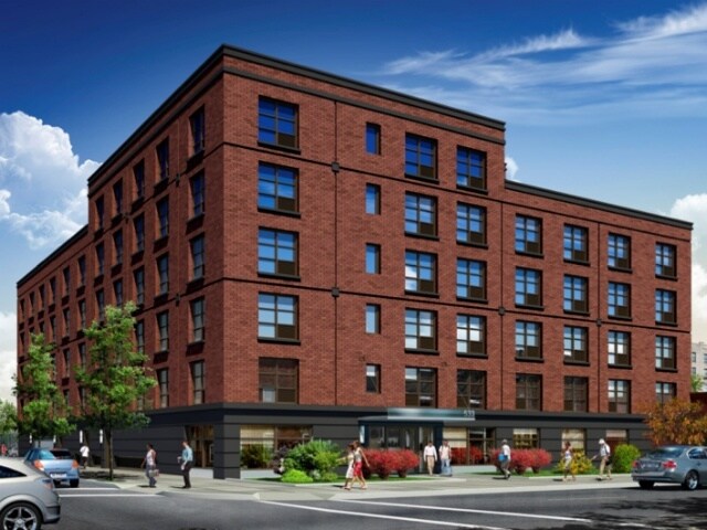
At 533 Bay St, find a great place to live. The address for this community is in the 10304 area of Staten Island. The team of leasing professionals is ready and waiting to show you our community. Come for a visit to see the available floorplan options. At 533 Bay St you're right at home. Stop by the community today.
533 Bay St is an apartment community located in Richmond County and the 10304 ZIP Code. This area is served by the New York City Geographic District #31 attendance zone.
Air Conditioning
Refrigerator
Tub/Shower
Heating
Once a bustling commercial center, Stapleton has a deep historical significance to Staten Island. Victorian-style mansions and the remnants of historic breweries remain in this neighborhood, but with the help of a growing community, Stapleton has been revitalized with the renovation of historic homes, addition of new apartment buildings, and the influx of new restaurants, businesses, and residents.
Along the shore of Upper New York Bay, Stapleton is a premier location with access to public buses and the Staten Island Railway. Many residents of Stapleton commute to neighboring cities including New York’s bustling boroughs of Brooklyn, Queens, and Manhattan.
Incredible apartment rentals line the waterfront of Stapleton offering scenic views and luxury amenities, while longstanding condos and renovated historic homes emanate a sense of coastal charm that defines this historic Staten Island neighborhood.
Learn more about living in StapletonCompare neighborhood and city base rent averages by bedroom.
| Stapleton | Staten Island, NY | |
|---|---|---|
| Studio | $2,144 | $1,586 |
| 1 Bedroom | $2,287 | $1,704 |
| 2 Bedrooms | $3,363 | $2,359 |
| 3 Bedrooms | $1,760 | $2,139 |
| Colleges & Universities | Distance | ||
|---|---|---|---|
| Colleges & Universities | Distance | ||
| Drive: | 7 min | 2.0 mi | |
| Drive: | 15 min | 6.0 mi | |
| Drive: | 27 min | 12.4 mi | |
| Drive: | 23 min | 12.7 mi |


Transportation options available in Staten Island include Bay Ridge-95 Street, located 5.5 miles from 533 Bay St. 533 Bay St is near Newark Liberty International, located 15.0 miles or 28 minutes away, and LaGuardia, located 21.9 miles or 39 minutes away.
| Transit / Subway | Distance | ||
|---|---|---|---|
| Transit / Subway | Distance | ||
|
|
Drive: | 12 min | 5.5 mi |
|
|
Drive: | 12 min | 5.8 mi |
|
|
Drive: | 13 min | 6.3 mi |
|
|
Drive: | 14 min | 6.7 mi |
|
|
Drive: | 18 min | 8.0 mi |
| Commuter Rail | Distance | ||
|---|---|---|---|
| Commuter Rail | Distance | ||
|
|
Walk: | 2 min | 0.2 mi |
|
|
Walk: | 12 min | 0.6 mi |
|
|
Walk: | 13 min | 0.7 mi |
|
|
Drive: | 5 min | 1.3 mi |
|
|
Drive: | 7 min | 2.4 mi |
| Airports | Distance | ||
|---|---|---|---|
| Airports | Distance | ||
|
Newark Liberty International
|
Drive: | 28 min | 15.0 mi |
|
LaGuardia
|
Drive: | 39 min | 21.9 mi |
Scores provided by
Traffic
-Airport
-Businesses
-Scores provided by
HowLoud What is a Sound Score Rating? A Sound Score Rating aggregates noise caused by vehicle traffic, airplane traffic and local sources. How It WorksTime and distance from 533 Bay St.
| Shopping Centers | Distance | ||
|---|---|---|---|
| Shopping Centers | Distance | ||
| Walk: | 7 min | 0.4 mi | |
| Drive: | 4 min | 1.2 mi | |
| Drive: | 5 min | 1.5 mi |
| Parks and Recreation | Distance | ||
|---|---|---|---|
| Parks and Recreation | Distance | ||
|
Alice Austen Park
|
Drive: | 4 min | 1.3 mi |
|
Staten Island Museum
|
Drive: | 4 min | 1.4 mi |
|
Silver Lake Park
|
Drive: | 5 min | 1.5 mi |
|
Mahoney Playground
|
Drive: | 4 min | 1.6 mi |
|
Staten Island Children's Museum
|
Drive: | 8 min | 2.7 mi |
| Hospitals | Distance | ||
|---|---|---|---|
| Hospitals | Distance | ||
| Drive: | 6 min | 2.1 mi | |
| Drive: | 12 min | 4.2 mi | |
| Drive: | 10 min | 4.2 mi |
| Military Bases | Distance | ||
|---|---|---|---|
| Military Bases | Distance | ||
| Walk: | 4 min | 0.2 mi | |
| Drive: | 13 min | 5.9 mi | |
| Drive: | 22 min | 9.9 mi |
What Are Walk Score®, Transit Score®, and Bike Score® Ratings?
Walk Score® measures the walkability of any address. Transit Score® measures access to public transit. Bike Score® measures the bikeability of any address.
What is a Sound Score Rating?
A Sound Score Rating aggregates noise caused by vehicle traffic, airplane traffic and local sources.


