
$3,200 / Month
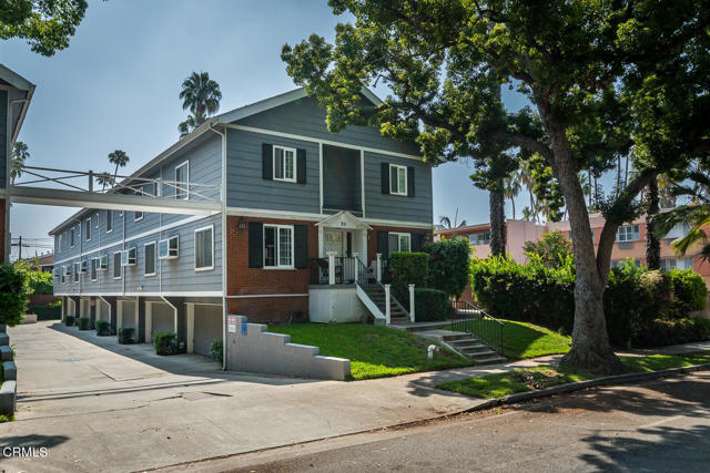
52 N Sierra Bonita Ave
Pasadena, CA 91106
1 Day Ago
Favorites
818-625-2777
-
Bedrooms
2
-
Bathrooms
3
-
Square Feet
1,156 sq ft
-
Available
Available Now
Highlights
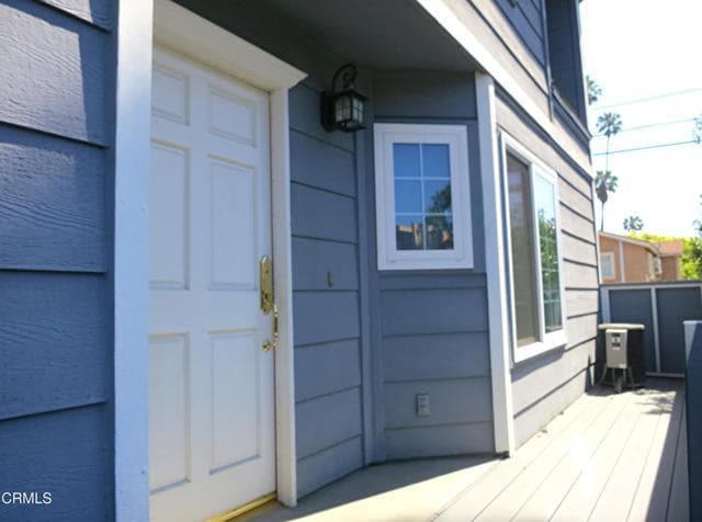
- Deck
- End Unit
- L-Shaped Dining Room
- Cottage
- 2 Car Attached Garage
- Oversized Parking
52 N Sierra Bonita Ave

Favorites
About This Home
12 Month Lease,
$3,200 deposit,
Available Now
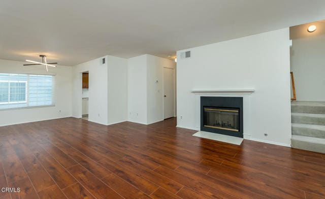
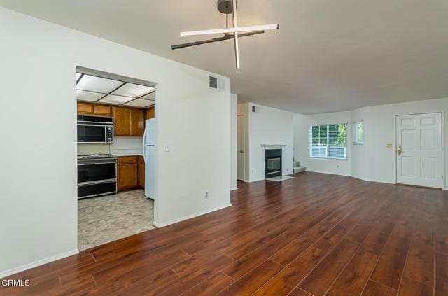
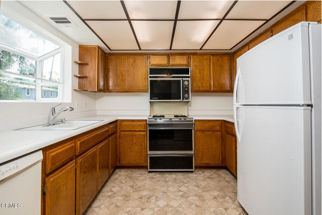
Beautifully maintained end-unit townhome located in a quiet, well-kept complex very near Pasadena City College. This spacious 2-bedroom, 2.5-bath home features a bright and open floor plan with a gas fireplace, cathedral ceilings, and private outdoor spaces including a usable front deck and small fenced-in yard--ideal for outdoor relaxation or exercise.Upstairs offers 2 large ensuite bedrooms with full baths, including a primary suite with vaulted ceilings. A convenient half bath is located on the main floor. Enjoy direct access to an oversized 2-car garage with ample storage and in-unit laundry complete with full-size washer and dryer units.Located in one of Pasadena's most walkable neighborhoods--steps to dining, shopping, entertainment, and the Rose Parade route. Minutes away from CalTech, SoLake Ave District, Fuller Seminary, Paseo Colorado and Old Town. MLS# P1-23178
52 N Sierra Bonita Ave is a townhome located in Los Angeles County and the 91106 ZIP Code. This area is served by the Pasadena Unified attendance zone.
* Price shown is base rent and may not include non-optional fees and utilities.
Price, availability, fees, and any applicable rent special are subject to change without notice.
* Square footage definitions vary. Displayed square footage is approximate.
Home Details
Home Type
Townhome
Year Built
Built in 1986
Bedrooms and Bathrooms
2.5 Bathrooms
2 Bedrooms
All Upper Level Bedrooms
Flooring
Carpet
Laminate
Home Design
Cottage
Interior Spaces
Living Room with Fireplace
L-Shaped Dining Room
Gas Fireplace
1,156 Sq Ft Home
3-Story Property
Kitchen
Free-Standing Range
Laundry
Laundry Room
Dryer
Laundry in Garage
Washer
Listing and Financial Details
Security Deposit $3,200
12-Month Minimum Lease Term
Available 7/11/25
Tax Lot 1
Tax Tract Number 462
Assessor Parcel Number 5737009086
Rent includes association dues, water, trash collection, sewer
Lot Details
0.38 Acre Lot
End Unit
Wood Fence
1 Common Wall
No Sprinklers
Outdoor Features
Deck
Patio
Exterior Lighting
Parking
2 Car Attached Garage
Oversized Parking
Parking Available
Utilities
Central Heating and Cooling System
Community Details
Overview
12 Units
Fees and Policies
The fees below are based on community-supplied data and may exclude additional fees and utilities.
- Parking
-
Other--
Details
Utilities Included
-
Water
-
Trash Removal
-
Sewer
Lease Options
-
12 Months
Contact
- Listed by Larry Mangubat | Engel & Voelkers Pasadena
- Phone Number
- Contact
-
Source
 California Regional Multiple Listing Service
Copyright 2025 © California Regional MLS. All rights reserved.
Location
Get Directions
Amenities
- Washer/Dryer
- Air Conditioning
- Heating
- Fireplace
- Range
- Refrigerator
- Carpet
- Vinyl Flooring
- Fenced Lot
- Patio
Expenses
Utilities Included
Water, Trash Removal, Sewer
Included
The Marceline neighborhood of Pasadena lies just 10 minutes from Los Angeles near the base of the San Gabriel Mountains. The 53-acre main campus of Pasadena City College, one of the largest community colleges in the United States, dominates the northern section of the neighborhood. The 124-acre campus of the California Institute of Technology lies to the west, and the vast Huntington library and botanical gardens sit to the south. The residents of the houses for rent along the neighborhood's quiet, tree-lined streets enjoy a warm, Mediterranean climate year-round.
For a unique shopping experience, browse for odds and ends at the Pasadena City College Flea Market. Sample some Indonesian and Singaporean cuisine at Q.Q. Kopitiam. Build your own pizza from scratch at the popular Pizza Press.
Learn more about living in Marceline
Education
| Colleges & Universities | Distance | ||
|---|---|---|---|
| Colleges & Universities | Distance | ||
| Walk: | 6 min | 0.3 mi | |
| Drive: | 4 min | 1.3 mi | |
| Drive: | 3 min | 1.5 mi | |
| Drive: | 7 min | 3.5 mi |
52 N Sierra Bonita Ave is within 6 minutes or 0.3 mile from Pasadena City College. It is also near Caltech and Fuller Theological Seminary.
Schools


Public Elementary School
Grades K-5
482 Students
Attendance Zone
Public Elementary School
Grades K-6
454 Students
Nearby
Public Middle School
Grades 6-8
386 Students
Attendance Zone
Public High School
Grades 9-12
1,609 Students
Attendance Zone
Private Elementary School
Grades PK-5
1,077 Students
Nearby
Private Elementary & Middle School
Grades 1-8
Nearby
Private Elementary, Middle & High School
Grades 1-12
73 Students
Nearby
School data provided by
 The GreatSchools Rating helps parents compare schools within a state based on a variety of school quality indicators and provides a helpful picture of how effectively each school serves all of its students. Ratings are on a scale of 1 (below average) to 10 (above average) and can include test scores, college readiness, academic progress, advanced courses, equity, discipline and attendance data. We also advise parents to visit schools, consider other information on school performance and programs, and consider family needs as part of the school selection process.
View GreatSchools Rating Methodology
Data provided by GreatSchools.org © 2025. All rights reserved.
View GreatSchools Rating Methodology
Data provided by GreatSchools.org © 2025. All rights reserved.
Transportation options available in Pasadena include Allen Station, located 0.7 mile from 52 N Sierra Bonita Ave. 52 N Sierra Bonita Ave is near Bob Hope, located 18.6 miles or 25 minutes away, and Los Angeles International, located 26.5 miles or 42 minutes away.
| Transit / Subway | Distance | ||
|---|---|---|---|
| Transit / Subway | Distance | ||
|
|
Walk: | 12 min | 0.7 mi |
|
|
Drive: | 4 min | 2.0 mi |
|
|
Drive: | 5 min | 2.2 mi |
|
|
Drive: | 5 min | 2.9 mi |
|
|
Drive: | 6 min | 3.3 mi |
| Commuter Rail | Distance | ||
|---|---|---|---|
| Commuter Rail | Distance | ||
|
|
Drive: | 18 min | 9.1 mi |
|
|
Drive: | 15 min | 11.0 mi |
|
|
Drive: | 19 min | 11.5 mi |
|
|
Drive: | 21 min | 11.5 mi |
| Drive: | 23 min | 15.6 mi |
| Airports | Distance | ||
|---|---|---|---|
| Airports | Distance | ||
|
Bob Hope
|
Drive: | 25 min | 18.6 mi |
|
Los Angeles International
|
Drive: | 42 min | 26.5 mi |
Time and distance from 52 N Sierra Bonita Ave.
| Shopping Centers | Distance | ||
|---|---|---|---|
| Shopping Centers | Distance | ||
| Walk: | 7 min | 0.4 mi | |
| Walk: | 10 min | 0.5 mi | |
| Walk: | 11 min | 0.6 mi |
52 N Sierra Bonita Ave has 3 shopping centers within 0.6 mile, which is about a 11-minute walk. The miles and minutes will be for the farthest away property.
| Parks and Recreation | Distance | ||
|---|---|---|---|
| Parks and Recreation | Distance | ||
|
Huntington Botanical Gardens
|
Drive: | 5 min | 1.5 mi |
|
Eaton Canyon Nature Center
|
Drive: | 7 min | 3.3 mi |
|
Kidspace Children's Museum
|
Drive: | 8 min | 3.8 mi |
|
Los Angeles County Arboretum
|
Drive: | 8 min | 4.5 mi |
|
Jet Propulsion Laboratory
|
Drive: | 8 min | 5.4 mi |
52 N Sierra Bonita Ave has 5 parks within 5.4 miles, including Huntington Botanical Gardens, Eaton Canyon Nature Center, and Kidspace Children's Museum.
| Hospitals | Distance | ||
|---|---|---|---|
| Hospitals | Distance | ||
| Drive: | 3 min | 1.8 mi | |
| Drive: | 5 min | 2.8 mi | |
| Drive: | 9 min | 3.7 mi |
52 N Sierra Bonita Ave has 3 hospitals within 3.7 miles, the nearest is Aurora Las Encinas Hospital which is 1.8 miles away and a 3 minute drive.
| Military Bases | Distance | ||
|---|---|---|---|
| Military Bases | Distance | ||
| Drive: | 39 min | 28.1 mi | |
| Drive: | 48 min | 31.5 mi |
52 N Sierra Bonita Ave is 28.1 miles from Los Angeles Air Force Base, and is convenient to other military bases, including Los Alamitos Army Airfield.
You May Also Like
Similar Rentals Nearby
-
-
-
-
1 / 50

-
-
-
-
-
-


What Are Walk Score®, Transit Score®, and Bike Score® Ratings?
Walk Score® measures the walkability of any address. Transit Score® measures access to public transit. Bike Score® measures the bikeability of any address.
What is a Sound Score Rating?
A Sound Score Rating aggregates noise caused by vehicle traffic, airplane traffic and local sources
52 N Sierra Bonita Ave
Pasadena, CA 91106