
$4,495
Total Monthly Price
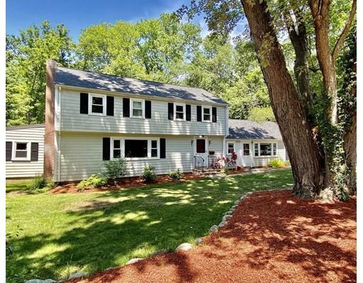
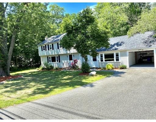
52 Eldred St
Lexington, MA 02420
2 Weeks Ago
|
Edit
Favorites
52 Eldred St

Favorites
Check Back Soon for Upcoming Availability
| Beds | Baths | Average SF |
|---|---|---|
| 4 Bedrooms 4 Bedrooms 4 Br | 2.5 Baths 2.5 Baths 2.5 Ba | — |
Fees and Policies
The fees below are based on community-supplied data and may exclude additional fees and utilities.
Pet policies are negotiable.
About This Property
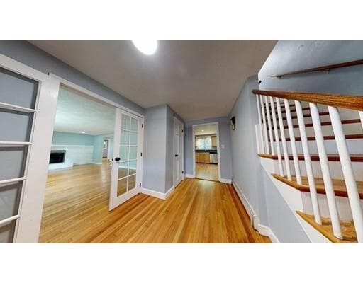
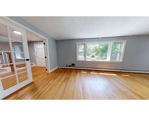
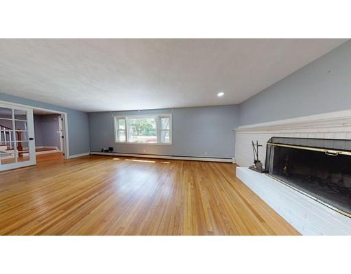
**VIRTUAL 3D TOUR AVAILABLE ** Spacious single family Colonial with over 2300 Sq.Ft of living space located within walking distance to the highly coveted Estabrook Elementary School & 1.5 Miles to Burlington Mall shopping area. This beautiful home features 9 rooms, 4 bedrooms + office, 2.5 bathrooms, & sits on almost an acre of land. Additional features include new roof, updated kitchen, brand new heating system with on demand hot-water, wood burning fire place, large back yard with kids play area, storage shed, & covered deck off formal dining room perfect for entertaining.
52 Eldred St is a house located in Middlesex County and the 02420 ZIP Code. This area is served by the Lexington attendance zone.
House Features
Dishwasher
Microwave
Refrigerator
Fireplace
- Fireplace
- Dishwasher
- Microwave
- Range
- Refrigerator
- Walking/Biking Trails
- Deck
Location
Get Directions
Known as the “Birthplace of American Liberty,” Lexington, Massachusetts has a sense of national pride that can be felt throughout the many neighborhoods that make up the city. Located just northwest of Boston, the North Lexington neighborhood adds its own spin on old-town charm.
North Lexington is a small, affluent suburban neighborhood within Lexington that prides itself in its high-quality schools and small-town feel. The residents of this neighborhood enjoy the piece of American history they reside in by visiting several Revolutionary war sites, including the Battle Green, Minutemen monument, and colonial architecture throughout their city. Hiking paths and conservation parks provide an active way for residents to appreciate the beauty and history of Lexington.
Learn more about living in North LexingtonBelow are rent ranges for similar nearby apartments
Amenities
- Fireplace
- Dishwasher
- Microwave
- Range
- Refrigerator
- Deck
- Walking/Biking Trails
Education
| Colleges & Universities | Distance | ||
|---|---|---|---|
| Colleges & Universities | Distance | ||
| Drive: | 14 min | 5.0 mi | |
| Drive: | 16 min | 9.1 mi | |
| Drive: | 19 min | 9.9 mi | |
| Drive: | 18 min | 10.3 mi |
52 Eldred St is within 14 minutes or 5.0 miles from Middlesex C.C., Bedford Campus. It is also near Bentley University and Brandeis University.
Schools


Public Elementary School
Grades PK-3
239 Students
Nearby
Public Elementary School
Grades K-5
542 Students
Attendance Zone
Public Middle School
Grades 6-8
942 Students
Attendance Zone
Public High School
Grades 9-12
2,303 Students
Attendance Zone
Private Elementary, Middle & High School
Grades 1-12
130 Students
Nearby
Private Elementary, Middle & High School
Grades 5-12
Nearby
School data provided by
 The GreatSchools Rating helps parents compare schools within a state based on a variety of school quality indicators and provides a helpful picture of how effectively each school serves all of its students. Ratings are on a scale of 1 (below average) to 10 (above average) and can include test scores, college readiness, academic progress, advanced courses, equity, discipline and attendance data. We also advise parents to visit schools, consider other information on school performance and programs, and consider family needs as part of the school selection process.
View GreatSchools Rating Methodology
Data provided by GreatSchools.org © 2025. All rights reserved.
View GreatSchools Rating Methodology
Data provided by GreatSchools.org © 2025. All rights reserved.
Transportation options available in Lexington include Medford/Tufts, located 9.6 miles from 52 Eldred St. 52 Eldred St is near General Edward Lawrence Logan International, located 21.5 miles or 32 minutes away, and Manchester Boston Regional, located 41.3 miles or 62 minutes away.
| Transit / Subway | Distance | ||
|---|---|---|---|
| Transit / Subway | Distance | ||
| Drive: | 19 min | 9.6 mi | |
|
|
Drive: | 17 min | 10.8 mi |
| Drive: | 16 min | 10.9 mi | |
|
|
Drive: | 19 min | 12.2 mi |
| Drive: | 21 min | 13.2 mi |
| Commuter Rail | Distance | ||
|---|---|---|---|
| Commuter Rail | Distance | ||
|
|
Drive: | 13 min | 7.9 mi |
|
|
Drive: | 14 min | 8.5 mi |
|
|
Drive: | 15 min | 8.5 mi |
|
|
Drive: | 14 min | 8.6 mi |
|
|
Drive: | 17 min | 10.0 mi |
| Airports | Distance | ||
|---|---|---|---|
| Airports | Distance | ||
|
General Edward Lawrence Logan International
|
Drive: | 32 min | 21.5 mi |
|
Manchester Boston Regional
|
Drive: | 62 min | 41.3 mi |
Time and distance from 52 Eldred St.
| Shopping Centers | Distance | ||
|---|---|---|---|
| Shopping Centers | Distance | ||
| Drive: | 3 min | 1.4 mi | |
| Drive: | 4 min | 1.7 mi | |
| Drive: | 8 min | 3.5 mi |
52 Eldred St has 3 shopping centers within 3.5 miles, which is about a 8-minute drive. The miles and minutes will be for the farthest away property.
| Parks and Recreation | Distance | ||
|---|---|---|---|
| Parks and Recreation | Distance | ||
|
Minute Man National Historical Park
|
Drive: | 9 min | 5.3 mi |
|
Mass Audubon's Habitat Education Center and Wildlife Sanctuary
|
Drive: | 15 min | 7.2 mi |
|
Walden Pond State Reservation
|
Drive: | 13 min | 7.6 mi |
|
Codman Community Farms
|
Drive: | 15 min | 8.1 mi |
|
Ralph Hill Conservation Area
|
Drive: | 20 min | 8.2 mi |
52 Eldred St has 5 parks within 8.2 miles, including Minute Man National Historical Park, Mass Audubon's Habitat Education Center and Wildlife Sanctuary, and Ralph Hill Conservation Area.
| Hospitals | Distance | ||
|---|---|---|---|
| Hospitals | Distance | ||
| Drive: | 8 min | 4.2 mi | |
| Drive: | 13 min | 6.9 mi | |
| Drive: | 17 min | 10.0 mi |
52 Eldred St has 3 hospitals within 10.0 miles, the nearest is Lahey Hospital & Medical Center, Burlington which is 4.2 miles away and a 8 minute drive.
| Military Bases | Distance | ||
|---|---|---|---|
| Military Bases | Distance | ||
| Drive: | 5 min | 2.4 mi |
52 Eldred St is 2.4 miles and a 5 minute drive from Hanscom Air Force Base.
You May Also Like
Similar Rentals Nearby
-
-

-

-

-

-

-

-

-
 $3,60012 Month LeaseHouse for Rent4 Beds | 3 Baths | 1,980 sq ft
 -
 $3,60012 Month LeaseHouse for Rent4 Beds | 1 Bath | 1,500 sq ft
What Are Walk Score®, Transit Score®, and Bike Score® Ratings?
Walk Score® measures the walkability of any address. Transit Score® measures access to public transit. Bike Score® measures the bikeability of any address.
What is a Sound Score Rating?
A Sound Score Rating aggregates noise caused by vehicle traffic, airplane traffic and local sources

52 Eldred St
Lexington, MA 02420