
$2,300
/ Month
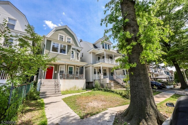
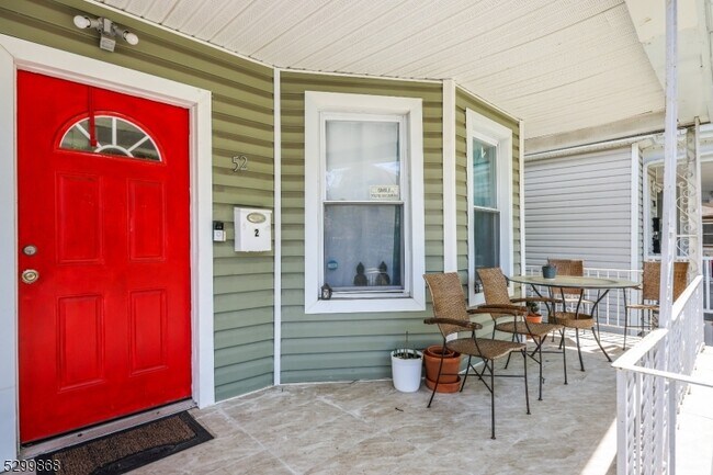
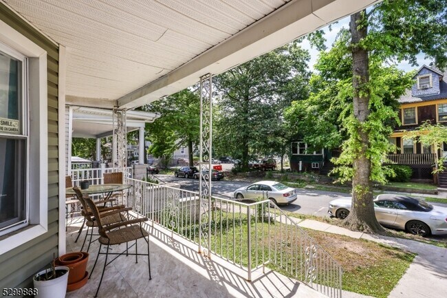
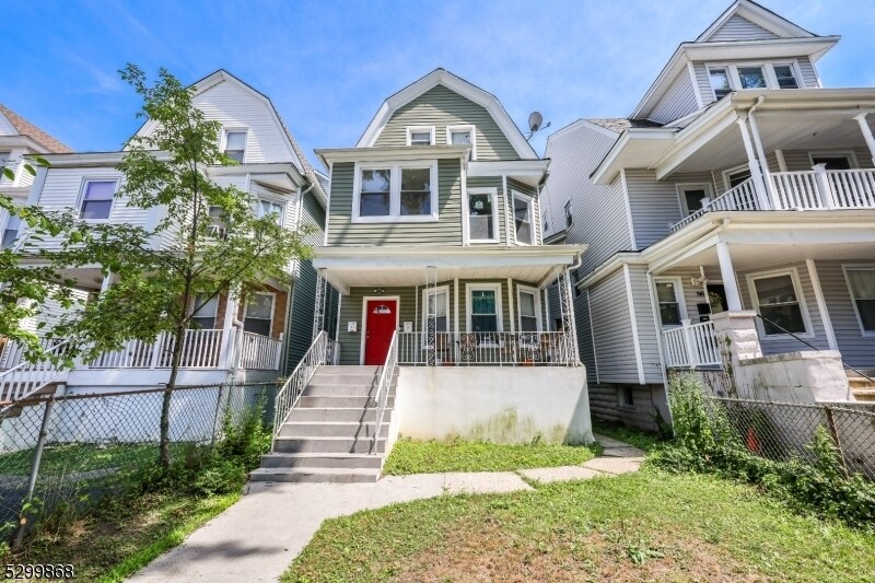
52 Amherst St
East Orange, NJ 07018
Favorites
52 Amherst St

Favorites
Check Back Soon for Upcoming Availability
| Beds | Baths | Average SF |
|---|---|---|
| 3 Bedrooms 3 Bedrooms 3 Br | 1 Bath 1 Bath 1 Ba | — |
Fees and Policies
The fees listed below are community-provided and may exclude utilities or add-ons. All payments are made directly to the property and are non-refundable unless otherwise specified.
About This Property
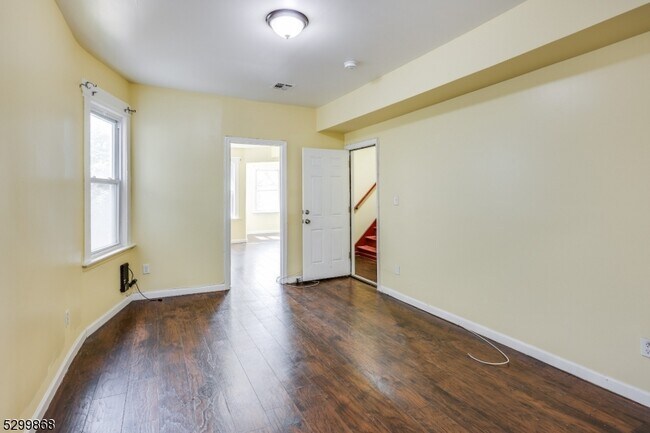
Come see this well kept, beautifully renovated second-floor apartment boasting stainless steel appliances, a spacious living room, and a primary bedroom that features an office nook plus walk-in closet. Conveniently situated just a short walk from the New Jersey Transit Train Station and close to Route 280 highway. Utilities are included in the rent. Tenant covers 1 month broker fee.
52 Amherst St is an apartment community located in Essex County and the 07018 ZIP Code.
Features
- Microwave
52 Amherst St,
East Orange,
NJ
07018
East Orange, NJ, sits just 12 miles from Manhattan, combining historic charm with contemporary city living. Tree-lined streets showcase the area's architectural heritage, from pre-war apartment buildings to classic single-family homes.
The city features established neighborhoods like Greenwood, known for its architectural character, and the Central Avenue Commercial District. Elmwood Park provides recreational opportunities with its swimming pool, tennis courts, and walking track. The East Orange Campus High School stands on the historic grounds of the former Upsala College, while the Whitney E. Houston Academy of Creative & Performing Arts honors the legendary singer's local roots. Two NJ Transit train stations offer direct service to New York City, making the area particularly accessible for commuters.
Learn more about living in East Orange
Amenities
- Microwave
Education
| Colleges & Universities | Distance | ||
|---|---|---|---|
| Colleges & Universities | Distance | ||
| Drive: | 7 min | 2.5 mi | |
| Drive: | 6 min | 2.9 mi | |
| Drive: | 6 min | 3.1 mi | |
| Drive: | 8 min | 3.5 mi |
52 Amherst St is within 7 minutes or 2.5 miles from Seton Hall University. It is also near N.J. Inst. of Technology and Bloomfield College.
Transportation options available in East Orange include Orange Street, located 2.3 miles from 52 Amherst St. 52 Amherst St is near Newark Liberty International, located 8.5 miles or 15 minutes away, and LaGuardia, located 29.4 miles or 45 minutes away.
| Transit / Subway | Distance | ||
|---|---|---|---|
| Transit / Subway | Distance | ||
|
|
Drive: | 5 min | 2.3 mi |
|
|
Drive: | 5 min | 2.4 mi |
|
|
Drive: | 6 min | 2.9 mi |
|
|
Drive: | 7 min | 3.2 mi |
|
|
Drive: | 8 min | 3.8 mi |
| Commuter Rail | Distance | ||
|---|---|---|---|
| Commuter Rail | Distance | ||
|
|
Walk: | 5 min | 0.3 mi |
|
|
Walk: | 10 min | 0.5 mi |
|
|
Drive: | 4 min | 1.5 mi |
|
|
Drive: | 4 min | 1.8 mi |
|
|
Drive: | 5 min | 2.1 mi |
| Airports | Distance | ||
|---|---|---|---|
| Airports | Distance | ||
|
Newark Liberty International
|
Drive: | 15 min | 8.5 mi |
|
LaGuardia
|
Drive: | 45 min | 29.4 mi |
Walkability Near 52 Amherst St East Orange, NJ 07018
Getting Around
 What do Walkability, Transit, Drivability, and Bikeability mean?
Walkability measures the walking distance to day-to-day needs.
Transit measures access to public transportation.
Drivability measures congestion, parking availability, and access to major roads.
Bikeability measures the suitability for cycling.
How It Works
What do Walkability, Transit, Drivability, and Bikeability mean?
Walkability measures the walking distance to day-to-day needs.
Transit measures access to public transportation.
Drivability measures congestion, parking availability, and access to major roads.
Bikeability measures the suitability for cycling.
How It Works
Exceptionally Walkable
Walkability
90
/ 100
Exceptional Public Transit
Transit
90
/ 100
Moderately Drivable
Drivability
60
/ 100
Fairly Bikeable
Bikeability
40
/ 100
Scores provided by
-
Soundscore™
-
/ 100
Traffic
-Airport
-Businesses
-Scores provided by
HowLoud What is a Sound Score Rating? A Sound Score Rating aggregates noise caused by vehicle traffic, airplane traffic and local sources. How It WorksTime and distance from 52 Amherst St.
| Shopping Centers | Distance | ||
|---|---|---|---|
| Shopping Centers | Distance | ||
| Walk: | 6 min | 0.3 mi | |
| Drive: | 4 min | 1.5 mi |
52 Amherst St has 2 shopping centers within 1.5 miles, which is about a 4-minute drive. The miles and minutes will be for the farthest away property.
| Parks and Recreation | Distance | ||
|---|---|---|---|
| Parks and Recreation | Distance | ||
|
Edison National Historic Site
|
Drive: | 6 min | 2.5 mi |
|
Newark Museum and Dreyfuss Planetarium
|
Drive: | 6 min | 3.2 mi |
|
Branch Brook Park
|
Drive: | 8 min | 3.6 mi |
|
Turtle Back Zoo
|
Drive: | 10 min | 4.4 mi |
|
Van Vleck House & Gardens
|
Drive: | 12 min | 5.5 mi |
52 Amherst St has 5 parks within 5.5 miles, including Edison National Historic Site, Newark Museum and Dreyfuss Planetarium, and Branch Brook Park.
| Hospitals | Distance | ||
|---|---|---|---|
| Hospitals | Distance | ||
| Walk: | 16 min | 0.8 mi | |
| Drive: | 5 min | 2.6 mi | |
| Drive: | 6 min | 3.0 mi |
52 Amherst St has 3 hospitals within 3.0 miles, the nearest is East Orange General Hospital which is 0.8 mile away and a 16 minute walk.
| Military Bases | Distance | ||
|---|---|---|---|
| Military Bases | Distance | ||
| Drive: | 20 min | 12.3 mi | |
| Drive: | 26 min | 14.3 mi | |
| Drive: | 30 min | 15.0 mi |
52 Amherst St has 3 military bases within 15.0 miles, the nearest is Military Ocean Terminal which is 12.3 miles away and a 20 minute drive.
You May Also Like
How do I access Social Services in New Jersey?
Statewide service is free, confidential, multilingual and always open. Three easy ways to reach Social Services in NJ: Dial 2-1-1; text your zip code to 898-211; or chat at https://www.nj211.org
Similar Rentals Nearby
-
-
-
-
-
1 / 15
 3 Beds$7,027+Total Monthly PriceTotal Monthly Price NewPrices include base rent and required monthly fees of $94. Variable costs based on usage may apply.Base Rent:3 Beds$6,932+2 Months Free
Pets Allowed
-
-
-
-
1 / 28

-


What Are Walk Score®, Transit Score®, and Bike Score® Ratings?
Walk Score® measures the walkability of any address. Transit Score® measures access to public transit. Bike Score® measures the bikeability of any address.
What is a Sound Score Rating?
A Sound Score Rating aggregates noise caused by vehicle traffic, airplane traffic and local sources.
52 Amherst St
East Orange, NJ 07018