
$3,000
/ Month
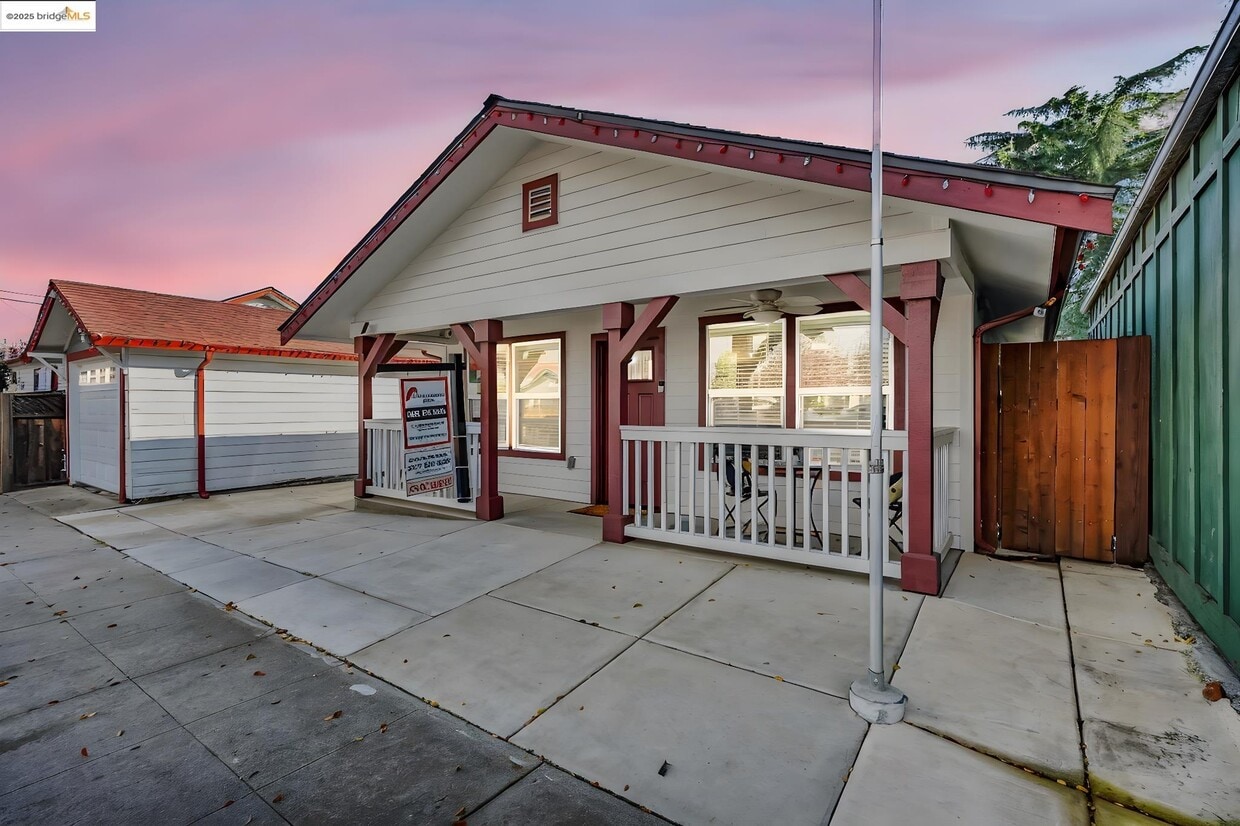
507 Maple St
Livermore, CA 94550
Today
|
Edit
Favorites
925-699-8880
-
Bedrooms
1
-
Bathrooms
1
-
Square Feet
736 sq ft
-
Available
Available Dec 17
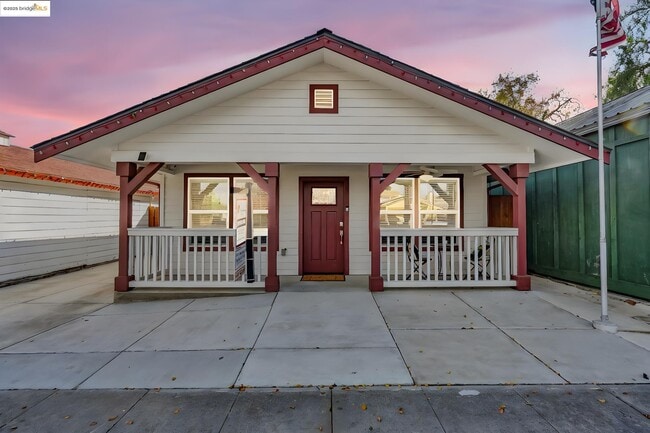
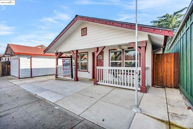
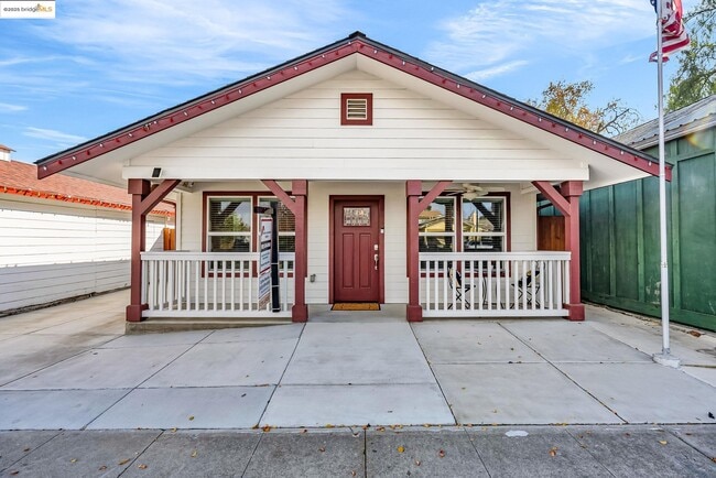
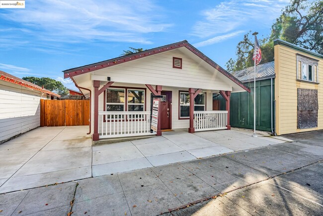
507 Maple St

Favorites
About This Home
Available Dec 17
Experience residential luxury living only 2 blocks from the heart of downtown Livermore. EXCEPTIONAL Single story ADU 736 sq. ft. with private front entry. Enjoy your own private space within this charming and modern home which includes every amenity and sleeps 2 adults and 2 children comfortably with one bedroom and den,which can be used as bedroom,office or creative space. All this plus a great pull down storage attic,washer,dryer,refrigerator and adorable patio! Garbage,and internet included + plenty of street parking. MAKE THIS YOURS!!
507 Maple St is a house located in Alameda County and the 94550 ZIP Code. This area is served by the Livermore Valley Joint Unified attendance zone.
* Price shown is base rent. Excludes user-selected optional fees and variable or usage-based fees and required charges due at or prior to move-in or at move-out. Price, availability, fees, and any applicable rent special are subject to change without notice.
* Square footage definitions vary. Displayed square footage is approximate.
Fees and Policies
The fees below are based on community-supplied data and may exclude additional fees and utilities.
-
Garage Lot
Property Fee Disclaimer: Based on community-supplied data and independent market research. Subject to change without notice. May exclude fees for mandatory or optional services and usage-based utilities.
House Features
- Air Conditioning
- Heating
Contact
- Listed by Cathie Marples | MARPLES & ASSOCIATES
- Phone Number
- Contact
-
Source
 bridgeMLS
Copyright© 2025 Bay East, Contra Costa, bridgeMLS. All rights reserved. All information provided by the listing agent/broker is deemed reliable but is not guaranteed and should be independently verified.
Location
Get Directions
Amenities
- Air Conditioning
- Heating
Located in California's wine country, Livermore combines scientific innovation with small-town charm. The city houses the Lawrence Livermore National Laboratory and Sandia National Laboratories, reflecting its evolution from agricultural roots. Current rental rates average $2,278 for one-bedroom apartments. The walkable downtown district along First Street features local shops and restaurants, while South Livermore Valley showcases over 40 wineries, including Wente Vineyards and Concannon Vineyard - both pioneering establishments from the 1880s that helped establish California's wine industry.
The Livermore Area Recreation and Park District maintains 1,842 acres of parks and open spaces, including Sycamore Grove Park and Robertson Park, offering trails and recreational facilities. The Mediterranean climate creates ideal conditions for outdoor activities and wine growing.
Learn more about living in Livermore
Education
| Colleges & Universities | Distance | ||
|---|---|---|---|
| Colleges & Universities | Distance | ||
| Drive: | 10 min | 4.5 mi | |
| Drive: | 20 min | 13.0 mi | |
| Drive: | 20 min | 13.9 mi | |
| Drive: | 26 min | 16.9 mi |
507 Maple St is within 10 minutes or 4.5 miles from Las Positas College. It is also near Diablo Valley Coll, San Ramon and San Joaquin Delta, Mtn. House.
Schools


Public Elementary School
Grades K-5
495 Students
Attendance Zone
Public Elementary School
Grades K-5
478 Students
Nearby
Public Middle School
Grades 6-8
547 Students
Attendance Zone
Public High School
Grades 9-12
1,765 Students
Attendance Zone
Private Elementary & Middle School
Grades K-8
Nearby
Private Elementary, Middle & High School
Grades 1-12
Nearby
Private Elementary School
Grades PK-3
Nearby
School data provided by
 The GreatSchools Rating helps parents compare schools within a state based on a variety of school quality indicators and provides a helpful picture of how effectively each school serves all of its students. Ratings are on a scale of 1 (below average) to 10 (above average) and can include test scores, college readiness, academic progress, advanced courses, equity, discipline and attendance data. We also advise parents to visit schools, consider other information on school performance and programs, and consider family needs as part of the school selection process.
View GreatSchools Rating Methodology
Data provided by GreatSchools.org © 2025. All rights reserved.
View GreatSchools Rating Methodology
Data provided by GreatSchools.org © 2025. All rights reserved.
Transportation options available in Livermore include Dublin Pleasanton Station, located 9.9 miles from 507 Maple St. 507 Maple St is near Metro Oakland International, located 28.7 miles or 37 minutes away, and Norman Y Mineta San Jose International, located 31.8 miles or 43 minutes away.
| Transit / Subway | Distance | ||
|---|---|---|---|
| Transit / Subway | Distance | ||
|
|
Drive: | 14 min | 9.9 mi |
|
|
Drive: | 13 min | 10.2 mi |
| Commuter Rail | Distance | ||
|---|---|---|---|
| Commuter Rail | Distance | ||
| Walk: | 8 min | 0.4 mi | |
| Walk: | 8 min | 0.4 mi | |
| Drive: | 7 min | 3.7 mi | |
| Drive: | 14 min | 7.5 mi | |
| Drive: | 14 min | 7.5 mi |
| Airports | Distance | ||
|---|---|---|---|
| Airports | Distance | ||
|
Metro Oakland International
|
Drive: | 37 min | 28.7 mi |
|
Norman Y Mineta San Jose International
|
Drive: | 43 min | 31.8 mi |
Time and distance from 507 Maple St.
| Shopping Centers | Distance | ||
|---|---|---|---|
| Shopping Centers | Distance | ||
| Walk: | 6 min | 0.3 mi | |
| Walk: | 10 min | 0.6 mi | |
| Walk: | 14 min | 0.8 mi |
507 Maple St has 3 shopping centers within 0.8 mile, which is about a 14-minute walk. The miles and minutes will be for the farthest away property.
| Parks and Recreation | Distance | ||
|---|---|---|---|
| Parks and Recreation | Distance | ||
|
Shadow Cliffs Regional Recreation Area
|
Drive: | 10 min | 5.1 mi |
|
Brushy Peak Regional Preserve
|
Drive: | 14 min | 6.7 mi |
|
Los Vaqueros Watershed
|
Drive: | 15 min | 8.1 mi |
|
Del Valle Regional Park
|
Drive: | 24 min | 8.3 mi |
|
Carnegie State Vehicle Recreation Area
|
Drive: | 21 min | 11.6 mi |
507 Maple St has 5 parks within 11.6 miles, including Shadow Cliffs Regional Recreation Area, Brushy Peak Regional Preserve, and Los Vaqueros Watershed.
| Hospitals | Distance | ||
|---|---|---|---|
| Hospitals | Distance | ||
| Drive: | 12 min | 8.1 mi |
507 Maple St is 8.1 miles and a 12 minute drive from Stanford Health Care - ValleyCare.
You May Also Like
Similar Rentals Nearby


What Are Walk Score®, Transit Score®, and Bike Score® Ratings?
Walk Score® measures the walkability of any address. Transit Score® measures access to public transit. Bike Score® measures the bikeability of any address.
What is a Sound Score Rating?
A Sound Score Rating aggregates noise caused by vehicle traffic, airplane traffic and local sources
507 Maple St
Livermore, CA 94550