
$1,500
/ Month
500 Gia Cir
Clifton Heights, PA 19018
Favorites
500 Gia Cir

Favorites
Check Back Soon for Upcoming Availability
| Beds | Baths | Average SF |
|---|---|---|
| 2 Bedrooms 2 Bedrooms 2 Br | 1 Bath 1 Bath 1 Ba | — |
About This Property
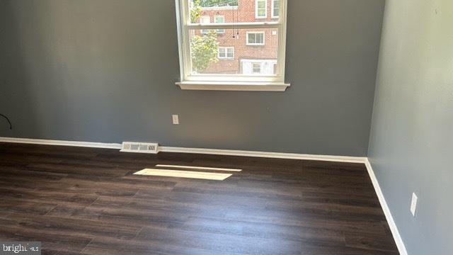
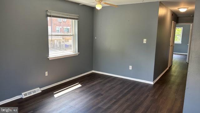
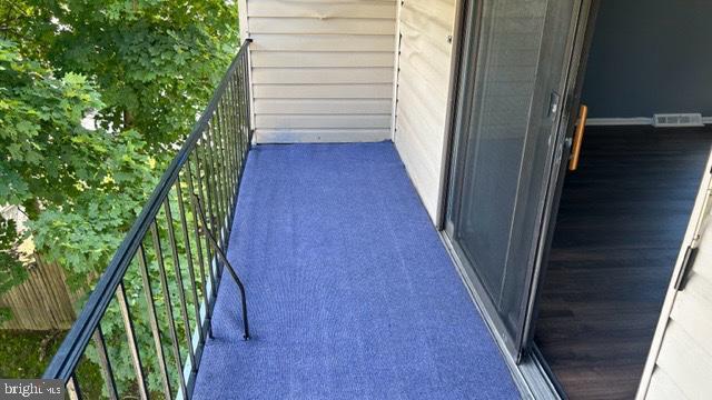
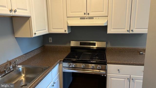
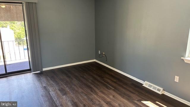
Come see this lovely 2 Bedroom, 1 full bath 2nd floor unit located on a quiet cul-de-sac. You have a large living room that leads to a balcony on which to relax in the afternoon. Dining Area is good size and you have an updated full kitchen. In the Hallway is a double closet, a full, clean hall bath. 2 large bedrooms each with their own double closet. Come se today. It will not last.
500 Gia Cir is an apartment community located in Delaware County and the 19018 ZIP Code.
Features
- Basement
500 Gia Cir,
Clifton Heights,
PA
19018
Clifton Heights is a compact borough in Delaware County, Pennsylvania, sitting about eight miles southwest of Philadelphia along Darby Creek. Despite covering just one square mile, it holds a dense, close-knit residential character that draws people who want suburban quiet with genuine proximity to a major city. Delaware County is the oldest settled section of Pennsylvania, and Clifton Heights grew out of that deep regional history as rail and road connections made suburban living practical in the early 20th century. The borough sits roughly midway between Philadelphia and the borough of Media, giving residents access to employment, culture, and services in both directions. A rail stop at Clifton-Aldan Station connects commuters directly to the city, and Interstate 476 runs just to the west. The rental market skews toward smaller apartment communities and multi-unit buildings rather than high-rises, reflecting the borough's modest footprint.
Learn more about living in Clifton Heights
Amenities
- Basement
Education
| Colleges & Universities | Distance | ||
|---|---|---|---|
| Colleges & Universities | Distance | ||
| Drive: | 10 min | 4.1 mi | |
| Drive: | 17 min | 6.1 mi | |
| Drive: | 21 min | 7.5 mi | |
| Drive: | 17 min | 7.7 mi |
500 Gia Cir is within 10 minutes or 4.1 miles from Swarthmore College. It is also near C.C. of Philadelphia, W Ctr and Haverford College.
Transportation options available in Clifton Heights include Baltimore Av, located 0.9 mile from 500 Gia Cir. 500 Gia Cir is near Philadelphia International, located 8.1 miles or 20 minutes away, and Trenton Mercer, located 42.7 miles or 72 minutes away.
| Transit / Subway | Distance | ||
|---|---|---|---|
| Transit / Subway | Distance | ||
| Walk: | 17 min | 0.9 mi | |
| Drive: | 4 min | 1.3 mi | |
| Drive: | 4 min | 1.4 mi | |
| Drive: | 4 min | 1.4 mi | |
| Drive: | 6 min | 1.7 mi |
| Commuter Rail | Distance | ||
|---|---|---|---|
| Commuter Rail | Distance | ||
|
|
Drive: | 3 min | 1.2 mi |
|
|
Drive: | 4 min | 1.2 mi |
|
|
Drive: | 5 min | 1.4 mi |
|
|
Drive: | 7 min | 1.9 mi |
|
|
Drive: | 5 min | 2.1 mi |
| Airports | Distance | ||
|---|---|---|---|
| Airports | Distance | ||
|
Philadelphia International
|
Drive: | 20 min | 8.1 mi |
|
Trenton Mercer
|
Drive: | 72 min | 42.7 mi |
Walkability Near 500 Gia Cir Clifton Heights, PA 19018
Getting Around
 What do Walkability, Transit, Drivability, and Bikeability mean?
Walkability measures the walking distance to day-to-day needs.
Transit measures access to public transportation.
Drivability measures congestion, parking availability, and access to major roads.
Bikeability measures the suitability for cycling.
How It Works
What do Walkability, Transit, Drivability, and Bikeability mean?
Walkability measures the walking distance to day-to-day needs.
Transit measures access to public transportation.
Drivability measures congestion, parking availability, and access to major roads.
Bikeability measures the suitability for cycling.
How It Works
Moderately Walkable
Walkability
60
/ 100
Limited Public Transit
Transit
30
/ 100
Moderately Drivable
Drivability
70
/ 100
Fairly Bikeable
Bikeability
40
/ 100
Scores provided by
-
Soundscore™
-
/ 100
Traffic
-Airport
-Businesses
-Scores provided by
HowLoud What is a Sound Score Rating? A Sound Score Rating aggregates noise caused by vehicle traffic, airplane traffic and local sources. How It WorksTime and distance from 500 Gia Cir.
| Shopping Centers | Distance | ||
|---|---|---|---|
| Shopping Centers | Distance | ||
| Walk: | 16 min | 0.8 mi | |
| Walk: | 16 min | 0.8 mi | |
| Drive: | 6 min | 1.6 mi |
500 Gia Cir has 3 shopping centers within 1.6 miles, which is about a 6-minute drive. The miles and minutes will be for the farthest away property.
| Parks and Recreation | Distance | ||
|---|---|---|---|
| Parks and Recreation | Distance | ||
|
Cobbs Creek Park
|
Drive: | 11 min | 4.1 mi |
|
Scott Arboretum
|
Drive: | 11 min | 4.1 mi |
|
Cobbs Creek Environmental Education Center
|
Drive: | 13 min | 4.8 mi |
|
John Heinz National Wildlife Refuge
|
Drive: | 13 min | 4.9 mi |
|
Hildacy Farm Preserve
|
Drive: | 14 min | 7.0 mi |
500 Gia Cir has 5 parks within 7.0 miles, including Cobbs Creek Park, Cobbs Creek Environmental Education Center, and Scott Arboretum.
| Hospitals | Distance | ||
|---|---|---|---|
| Hospitals | Distance | ||
| Drive: | 9 min | 2.6 mi | |
| Drive: | 8 min | 2.8 mi | |
| Drive: | 20 min | 7.1 mi |
500 Gia Cir has 3 hospitals within 7.1 miles, the nearest is Delaware County Memorial Hospital which is 2.6 miles away and a 9 minute drive.
| Military Bases | Distance | ||
|---|---|---|---|
| Military Bases | Distance | ||
| Drive: | 24 min | 10.5 mi | |
| Drive: | 48 min | 29.8 mi | |
| Drive: | 52 min | 31.7 mi |
500 Gia Cir has 3 military bases within 31.7 miles, the nearest is Philadelphia Naval Busi Center which is 10.5 miles away and a 24 minute drive.
You May Also Like
Similar Rentals Nearby


What Are Walk Score®, Transit Score®, and Bike Score® Ratings?
Walk Score® measures the walkability of any address. Transit Score® measures access to public transit. Bike Score® measures the bikeability of any address.
What is a Sound Score Rating?
A Sound Score Rating aggregates noise caused by vehicle traffic, airplane traffic and local sources.
500 Gia Cir
Clifton Heights, PA 19018