
$3,975 / Month
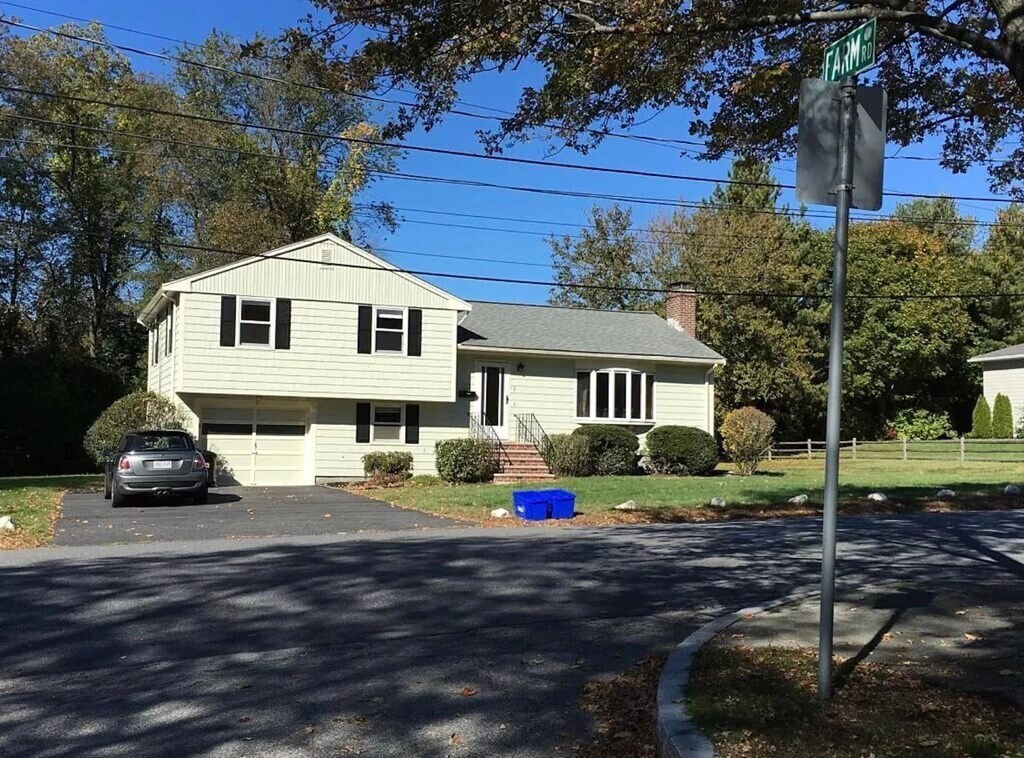
5 Lillian Rd
Lexington, MA 02420
2 Weeks Ago
Favorites
5 Lillian Rd

Favorites
Check Back Soon for Upcoming Availability
| Beds | Baths | Average SF |
|---|---|---|
| 4 Bedrooms 4 Bedrooms 4 Br | 2 Baths 2 Baths 2 Ba | 1,968 SF |
About This Property
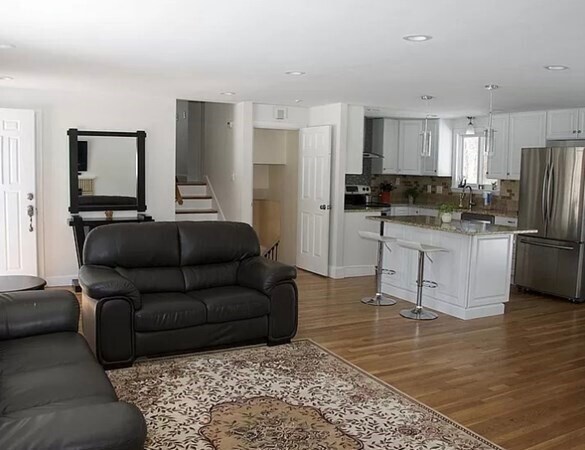
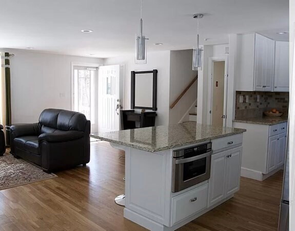
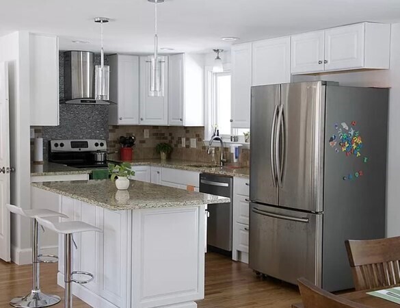
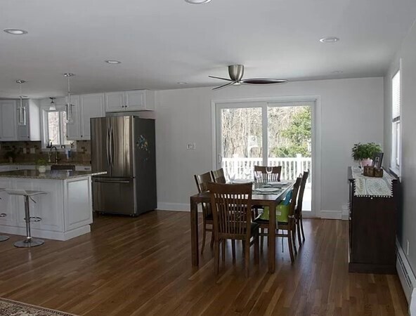
Beautiful single family,recently renovated,home on a large 1/3 acre flat lot in Bowman school district of Lexington. Multi level home with 3/4 Bedrooms,2 full baths and hardwood floors throughout. Large deck overlooking lush green conservation land makes the house perfect for entertainment as well as for peaceful living. Modern kitchen with stainless steel appliances and lots of counter space. Great light all year round. Close to lexington center and to the minuteman bike trail. Fenced yard for privacy. Solar electricity. Fireplaced living room open to dining area and deck for great flow.
5 Lillian Rd is a house located in Middlesex County and the 02420 ZIP Code. This area is served by the Lexington attendance zone.
Location
Get Directions
Much of Lexington’s local culture is rooted in the town’s role in the American Revolution, but the community is much more than a historical landmark. Sitting only about 30 minutes outside downtown Boston, folks renting in Lexington are far enough removed from the urban core to enjoy a quiet lifestyle while close enough for an easy commute.
Dozens of public parks dot the community, offering endless opportunities for enjoying nature right in your own neighborhood. The Minuteman Bikeway connects Lexington to Bedford in the north and Arlington and Cambridge in the south. The schools in the area get excellent marks and the crime rate is among the lowest in the nation, so the community is highly desirable for families.
Learn more about living in LexingtonBelow are rent ranges for similar nearby apartments
Education
| Colleges & Universities | Distance | ||
|---|---|---|---|
| Colleges & Universities | Distance | ||
| Drive: | 9 min | 5.1 mi | |
| Drive: | 12 min | 6.0 mi | |
| Drive: | 11 min | 6.1 mi | |
| Drive: | 11 min | 6.5 mi |
5 Lillian Rd is within 9 minutes or 5.1 miles from Tufts Univ., Medford. It is also near Bentley University and Lesley University, Porter.
Schools


Public Elementary School
Grades PK-5
422 Students
Nearby
Public Elementary School
Grades K-5
396 Students
Attendance Zone
Public Middle School
Grades 6-8
823 Students
Attendance Zone
Public High School
Grades 9-12
2,303 Students
Attendance Zone
Private Elementary School
Grades PK-5
96 Students
Nearby
Private Middle & High School
Grades 6-12
307 Students
Nearby
School data provided by
 The GreatSchools Rating helps parents compare schools within a state based on a variety of school quality indicators and provides a helpful picture of how effectively each school serves all of its students. Ratings are on a scale of 1 (below average) to 10 (above average) and can include test scores, college readiness, academic progress, advanced courses, equity, discipline and attendance data. We also advise parents to visit schools, consider other information on school performance and programs, and consider family needs as part of the school selection process.
View GreatSchools Rating Methodology
Data provided by GreatSchools.org © 2025. All rights reserved.
View GreatSchools Rating Methodology
Data provided by GreatSchools.org © 2025. All rights reserved.
Transportation options available in Lexington include Alewife Station, located 4.4 miles from 5 Lillian Rd. 5 Lillian Rd is near General Edward Lawrence Logan International, located 12.8 miles or 23 minutes away.
| Transit / Subway | Distance | ||
|---|---|---|---|
| Transit / Subway | Distance | ||
|
|
Drive: | 8 min | 4.4 mi |
| Drive: | 7 min | 4.4 mi | |
|
|
Drive: | 10 min | 4.8 mi |
| Drive: | 9 min | 4.9 mi | |
| Drive: | 11 min | 5.5 mi |
| Commuter Rail | Distance | ||
|---|---|---|---|
| Commuter Rail | Distance | ||
|
|
Drive: | 6 min | 3.3 mi |
|
|
Drive: | 7 min | 3.8 mi |
|
|
Drive: | 7 min | 3.9 mi |
|
|
Drive: | 7 min | 4.0 mi |
|
|
Drive: | 8 min | 4.3 mi |
| Airports | Distance | ||
|---|---|---|---|
| Airports | Distance | ||
|
General Edward Lawrence Logan International
|
Drive: | 23 min | 12.8 mi |
Time and distance from 5 Lillian Rd.
| Shopping Centers | Distance | ||
|---|---|---|---|
| Shopping Centers | Distance | ||
| Drive: | 2 min | 1.2 mi | |
| Drive: | 6 min | 3.2 mi | |
| Drive: | 8 min | 4.1 mi |
5 Lillian Rd has 3 shopping centers within 4.1 miles, which is about a 8-minute drive. The miles and minutes will be for the farthest away property.
| Parks and Recreation | Distance | ||
|---|---|---|---|
| Parks and Recreation | Distance | ||
|
Mass Audubon's Habitat Education Center and Wildlife Sanctuary
|
Drive: | 7 min | 3.0 mi |
|
Beaver Brook Reservation
|
Drive: | 9 min | 4.7 mi |
|
Harvard-Smithsonian Center for Astrophysics
|
Drive: | 11 min | 6.0 mi |
|
Longfellow National Historic Site
|
Drive: | 11 min | 6.4 mi |
|
Walter D. Stone Memorial Zoo
|
Drive: | 16 min | 9.3 mi |
5 Lillian Rd has 5 parks within 9.3 miles, including Mass Audubon's Habitat Education Center and Wildlife Sanctuary, Beaver Brook Reservation, and Harvard-Smithsonian Center for Astrophysics.
| Hospitals | Distance | ||
|---|---|---|---|
| Hospitals | Distance | ||
| Drive: | 8 min | 4.0 mi | |
| Drive: | 9 min | 4.6 mi | |
| Drive: | 10 min | 5.3 mi |
5 Lillian Rd has 3 hospitals within 5.3 miles, the nearest is McLean Hospital Corporation which is 4.0 miles away and a 8 minute drive.
| Military Bases | Distance | ||
|---|---|---|---|
| Military Bases | Distance | ||
| Drive: | 14 min | 6.3 mi | |
| Drive: | 31 min | 18.2 mi |
5 Lillian Rd is 6.3 miles from Hanscom Air Force Base, and is convenient to other military bases, including US Military Reservation.
You May Also Like
Similar Rentals Nearby


What Are Walk Score®, Transit Score®, and Bike Score® Ratings?
Walk Score® measures the walkability of any address. Transit Score® measures access to public transit. Bike Score® measures the bikeability of any address.
What is a Sound Score Rating?
A Sound Score Rating aggregates noise caused by vehicle traffic, airplane traffic and local sources

5 Lillian Rd
Lexington, MA 02420