
$2,100
/ Month
4890 Lougheed Hwy. Unit 401
Burnaby, BC V5C 0N2
Favorites
604-899-2333
-
Bedrooms
1
-
Bathrooms
1
-
Square Feet
545 sq ft
-
Available
Available Jun 1
4890 Lougheed Hwy. Unit 401

Favorites
About This Home
Available Jun 1
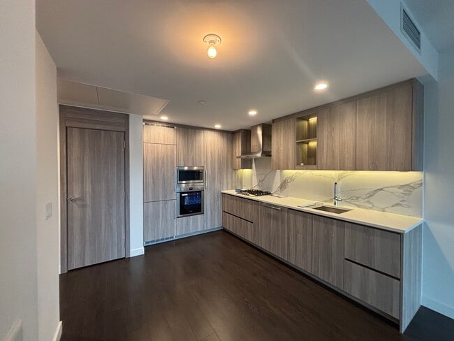
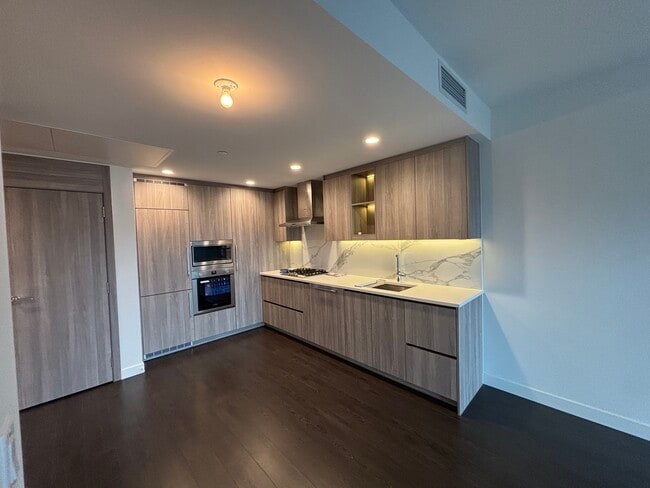
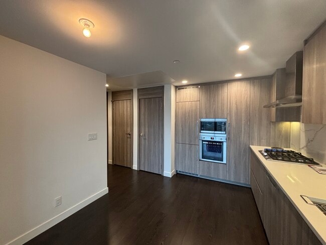
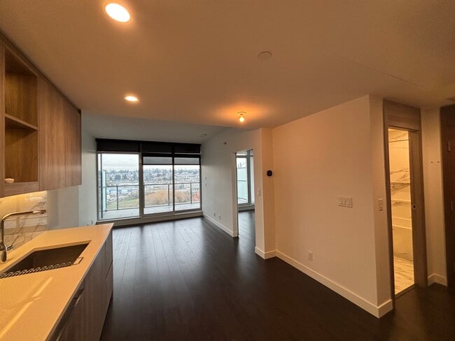
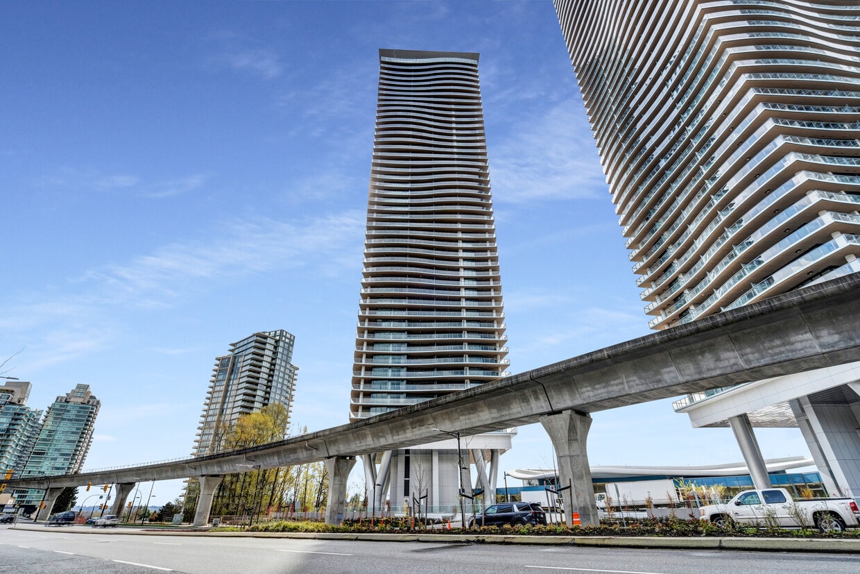
401-4890 Lougheed Highway Bienvenue à Brentwood Hillside East ! Situé le long de la route Lougheed, dans le quartier animé de Brentwood à Burnaby, Brentwood Hillside East est un projet résidentiel remarquable au sein de la communauté planifiée de Concord Brentwood. Cette phase comprend deux tours impressionnantes dotées de balcons incurvés surdimensionnés qui créent une façade ondulée et offrent des vues panoramiques sur le paysage urbain et naturel environnant. Les résidents bénéficient d'une sélection d'équipements conçus pour améliorer leur style de vie et la vie communautaire, notamment un centre de remise en forme, des salons de divertissement et de magnifiques espaces extérieurs aménagés, parfaits pour la détente et les rassemblements. Son emplacement privilégié offre un accès facile aux commerces, restaurants et lieux de divertissement. Le centre commercial Brentwood Town Centre est à deux pas, et les stations de SkyTrain et les grands axes routiers à proximité facilitent les déplacements dans tout le Grand Vancouver. Brentwood Hillside East allie architecture moderne, commodités de qualité et avantages de la vie urbaine au cœur de Burnaby. 401-4890 Lougheed Highway Comprend : 1 chambre 1 salle de bain 545 pieds carrés Balcon Lave-vaisselle Buanderie dans l'appartement Stationnement inclus Gaz et eau inclus Casier de rangement inclus Animaux acceptés Non meublé
4890 Lougheed Hwy. is a rental located in Burnaby, BC. This listing has rentals from $2100
* Price shown is base rent. Excludes user-selected optional fees and variable or usage-based fees and required charges due at or prior to move-in or at move-out. Price, availability, fees, and any applicable rent special are subject to change without notice.
* Square footage definitions vary. Displayed square footage is approximate.
Contact
- Listed by Rhenti | Rhenti
- Phone Number
- Contact
Location
Get Directions
Mountains framing a lake, scenic vistas, and wooded trails are just the beginning of what makes Burnaby special. This beautiful city sits on the east side of Vancouver, and 25% of the city consists of parks and green space—one of the highest parks-to-residents ratios in North America.
While the surroundings are lush and peaceful, Burnaby is also a tech and education hub, home to the British Columbia Institute of Technology and Simon Fraser University, along with a wide range of high-tech companies. With so much natural beauty to enjoy, it’s no wonder Burnaby is walkable and bike-friendly. Trails criss-cross the city, and hikers can explore more than 230 kilometres of routes, including Burnaby Mountain Park, which offers views of Vancouver and destinations like the Playground of the Gods.
Framed by Vancouver Harbour and the Fraser River—and home to Burnaby Lake and Deer Lake—residents enjoy boating, kayaking, water-skiing, and swimming.
Learn more about living in Burnaby
Education
| Colleges & Universities | Distance | ||
|---|---|---|---|
| Colleges & Universities | Distance | ||
| Drive: | 6 min | 4.1 km | |
| Drive: | 7 min | 5.4 km | |
| Drive: | 11 min | 8.4 km | |
| Drive: | 13 min | 10.3 km |
4890 Lougheed Hwy. Unit 401 is within 6 minutes or 4.1 kilometers from BC Institute of Technology. It is also near LaSalle College Vancouver and Simon Fraser Univ., Burnaby.
Transportation options available in Burnaby include Brentwood Town Centre Station, located 0.7 kilometer from 4890 Lougheed Hwy. Unit 401. 4890 Lougheed Hwy. Unit 401 is near Vancouver International, located 22.4 kilometers or 38 minutes away, and Abbotsford International, located 61.1 kilometers or 51 minutes away.
| Transit / Subway | Distance | ||
|---|---|---|---|
| Transit / Subway | Distance | ||
|
|
Walk: | 8 min | 0.7 km |
|
|
Walk: | 9 min | 0.8 km |
|
|
Drive: | 2 min | 2.3 km |
|
|
Drive: | 3 min | 2.9 km |
|
|
Drive: | 6 min | 4.5 km |
| Commuter Rail | Distance | ||
|---|---|---|---|
| Commuter Rail | Distance | ||
|
|
Drive: | 14 min | 9.9 km |
|
|
Drive: | 17 min | 11.9 km |
|
|
Drive: | 17 min | 12.0 km |
|
|
Drive: | 17 min | 12.8 km |
|
|
Drive: | 17 min | 12.8 km |
| Airports | Distance | ||
|---|---|---|---|
| Airports | Distance | ||
|
Vancouver International
|
Drive: | 38 min | 22.4 km |
|
Abbotsford International
|
Drive: | 51 min | 61.1 km |
Getting Around
 What do Walkability, Transit, Drivability, and Bikeability mean?
Walkability measures the walking distance to day-to-day needs.
Transit measures access to public transportation.
Drivability measures congestion, parking availability, and access to major roads.
Bikeability measures the suitability for cycling.
How It Works
What do Walkability, Transit, Drivability, and Bikeability mean?
Walkability measures the walking distance to day-to-day needs.
Transit measures access to public transportation.
Drivability measures congestion, parking availability, and access to major roads.
Bikeability measures the suitability for cycling.
How It Works
Moderately Walkable
Walkability
60
/ 100
Good Public Transit
Transit
70
/ 100
Very Drivable
Drivability
80
/ 100
Moderately Bikeable
Bikeability
60
/ 100
Scores provided by
-
Soundscore™
-
/ 100
Traffic
-Airport
-Businesses
-Scores provided by
HowLoud What is a Sound Score Rating? A Sound Score Rating aggregates noise caused by vehicle traffic, airplane traffic and local sources. How It WorksTime and distance from 4890 Lougheed Hwy. Unit 401.
| Shopping Centers | Distance | ||
|---|---|---|---|
| Shopping Centers | Distance | ||
| Drive: | 3 min | 2.5 km | |
| Drive: | 5 min | 3.6 km | |
| Drive: | 5 min | 4.0 km |
4890 Lougheed Hwy. Unit 401 has 3 shopping centers within 4.0 kilometers, which is about a 5-minute drive. The kilometers and minutes will be for the farthest away property.
| Parks and Recreation | Distance | ||
|---|---|---|---|
| Parks and Recreation | Distance | ||
|
Thunderbird Park
|
Drive: | 5 min | 4.3 km |
|
Adanac Park
|
Drive: | 6 min | 4.3 km |
|
Charles Park
|
Drive: | 6 min | 4.7 km |
|
Rupert Park
|
Drive: | 7 min | 5.1 km |
|
Falaise Park
|
Drive: | 7 min | 5.1 km |
4890 Lougheed Hwy. Unit 401 has 5 parks within 5.1 kilometers, including Adanac Park, Thunderbird Park, and Charles Park.
| Military Bases | Distance | ||
|---|---|---|---|
| Military Bases | Distance | ||
| Drive: | 188 min | 120.9 km |
4890 Lougheed Hwy. Unit 401 is 120.9 kilometers and a 188 minute drive from Canadian Forces Base Esquimalt.
You May Also Like
Similar Rentals Nearby


What Are Walk Score®, Transit Score®, and Bike Score® Ratings?
Walk Score® measures the walkability of any address. Transit Score® measures access to public transit. Bike Score® measures the bikeability of any address.
What is a Sound Score Rating?
A Sound Score Rating aggregates noise caused by vehicle traffic, airplane traffic and local sources.
4890 Lougheed Hwy.
Burnaby, BC V5C 0N2