$3,550
Total Monthly Price
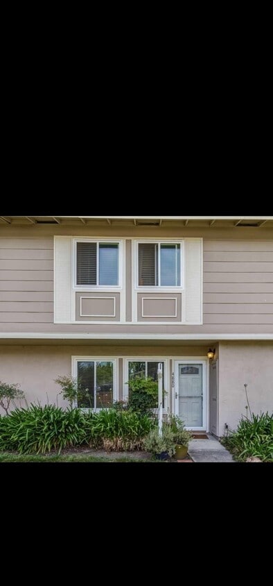
4880 Saginaw Cir
Pleasanton, CA 94588
Favorites
669-333-3953
-
Bedrooms
3
-
Bathrooms
1.5
-
Square Feet
1,130 sq ft
-
Available
Available Now
Highlight
- Patio
4880 Saginaw Cir

Favorites
About This Home
12 Month Lease,
$3,550 deposit,
Available Now
3 bed 1.5 bath fully remodelled 2x floors and ready to.move in with detached 2x car ports behind the patio door and a private backyard. Full bath has walkin shower Centralized heating and cooling New carpets on bedrooms Laminate floors Wooden stairs Washer and dryer microwave ,electric range and refrigerator
4880 Saginaw Cir is a townhome located in Alameda County and the 94588 ZIP Code.
* Price shown is total price based on community-supplied monthly required fees. Excludes user-selected optional fees and variable or usage-based fees and required charges due at or prior to move-in or at move-out. Price, availability, fees, and any applicable rent special are subject to change without notice.
* Square footage definitions vary. Displayed square footage is approximate.
Townhome Features
Microwave
Refrigerator
Heating
Range
- Heating
- Microwave
- Range
- Refrigerator
- Carpet
- Patio
Contact
- Phone Number
- Contact
Location
Get Directions
The cities of Livermore, Dublin and Pleasanton form a loosely shaped triangle within California's Tri-Valley region, a cluster of three small valleys about 33 miles east of San Francisco and 35 miles northeast of San Jose. Known for its Mediterranean climate, rolling hills and historic vineyards, this once bucolic region now boasts three separate downtown areas, a bustling business community and some of the best wineries in the state.
At the eastern end of the region lies the city of Livermore. Once known as Livermores, Livermore Ranch and Nottingham, the city sits at the center of Livermore Valley, a historic region dotted with more than 5,000 acres of mostly family-owned vineyards. A pastoral neighborhood known for its charming yet functional hilltop windmills, Livermore hosts the internationally recognized and sometimes controversial center of scientific research, Lawrence Livermore National Laboratories.
Learn more about living in Dublin/Pleasanton/Livermore
Education
| Colleges & Universities | Distance | ||
|---|---|---|---|
| Colleges & Universities | Distance | ||
| Drive: | 11 min | 6.3 mi | |
| Drive: | 12 min | 6.5 mi | |
| Drive: | 23 min | 14.0 mi | |
| Drive: | 24 min | 15.8 mi |
4880 Saginaw Cir is within 12 minutes or 6.5 miles from Diablo Valley Coll, San Ramon. It is also near Las Positas College and Ohlone College, Fremont Campus.
Transportation options available in Pleasanton include Dublin Pleasanton Station, located 2.5 miles from 4880 Saginaw Cir. 4880 Saginaw Cir is near Metro Oakland International, located 22.1 miles or 29 minutes away, and Norman Y Mineta San Jose International, located 28.9 miles or 41 minutes away.
| Transit / Subway | Distance | ||
|---|---|---|---|
| Transit / Subway | Distance | ||
|
|
Drive: | 5 min | 2.5 mi |
|
|
Drive: | 6 min | 3.7 mi |
| Commuter Rail | Distance | ||
|---|---|---|---|
| Commuter Rail | Distance | ||
| Drive: | 8 min | 3.0 mi | |
| Drive: | 12 min | 7.8 mi | |
| Drive: | 15 min | 10.5 mi | |
| Drive: | 30 min | 18.0 mi | |
| Drive: | 30 min | 18.1 mi |
| Airports | Distance | ||
|---|---|---|---|
| Airports | Distance | ||
|
Metro Oakland International
|
Drive: | 29 min | 22.1 mi |
|
Norman Y Mineta San Jose International
|
Drive: | 41 min | 28.9 mi |
Getting Around
 What do Walkability, Transit, Drivability, and Bikeability mean?
Walkability measures the walking distance to day-to-day needs.
Transit measures access to public transportation.
Drivability measures congestion, parking availability, and access to major roads.
Bikeability measures the suitability for cycling.
How It Works
What do Walkability, Transit, Drivability, and Bikeability mean?
Walkability measures the walking distance to day-to-day needs.
Transit measures access to public transportation.
Drivability measures congestion, parking availability, and access to major roads.
Bikeability measures the suitability for cycling.
How It Works
Moderately Walkable
Walkability
60
/ 100
Some Public Transit
Transit
40
/ 100
Exceptionally Drivable
Drivability
90
/ 100
Moderately Bikeable
Bikeability
70
/ 100
Scores provided by
-
Soundscore™
-
/ 100
Traffic
-Airport
-Businesses
-Scores provided by
HowLoud What is a Sound Score Rating? A Sound Score Rating aggregates noise caused by vehicle traffic, airplane traffic and local sources. How It WorksTime and distance from 4880 Saginaw Cir.
| Shopping Centers | Distance | ||
|---|---|---|---|
| Shopping Centers | Distance | ||
| Walk: | 5 min | 0.3 mi | |
| Walk: | 8 min | 0.4 mi | |
| Walk: | 12 min | 0.6 mi |
4880 Saginaw Cir has 3 shopping centers within 0.6 mile, which is about a 12-minute walk. The miles and minutes will be for the farthest away property.
| Parks and Recreation | Distance | ||
|---|---|---|---|
| Parks and Recreation | Distance | ||
|
Shadow Cliffs Regional Recreation Area
|
Drive: | 9 min | 3.5 mi |
|
Dublin Hills Regional Parks
|
Drive: | 17 min | 6.7 mi |
|
Bishop Ranch Regional Preserve
|
Drive: | 14 min | 9.3 mi |
|
Pleasanton Ridge Regional Park
|
Drive: | 19 min | 12.8 mi |
|
Garin/Dry Creek Pioneer Parks
|
Drive: | 32 min | 19.6 mi |
4880 Saginaw Cir has 5 parks within 19.6 miles, including Shadow Cliffs Regional Recreation Area, Dublin Hills Regional Parks, and Pleasanton Ridge Regional Park.
| Hospitals | Distance | ||
|---|---|---|---|
| Hospitals | Distance | ||
| Walk: | 2 min | 0.1 mi | |
| Drive: | 15 min | 10.4 mi |
4880 Saginaw Cir is 0.1 mile from Stanford Health Care - ValleyCare, and is convenient to other hospitals, including San Ramon Regional Medical Center.
| Military Bases | Distance | ||
|---|---|---|---|
| Military Bases | Distance | ||
| Drive: | 41 min | 29.6 mi | |
| Drive: | 41 min | 29.8 mi | |
| Drive: | 46 min | 31.7 mi |
4880 Saginaw Cir has 3 military bases within 31.7 miles, the nearest is Alameda/US Naval Air Station Alameda which is 29.6 miles away and a 41 minute drive.
Amenities
- Heating
- Microwave
- Range
- Refrigerator
- Carpet
- Patio
4880 Saginaw Cir Photos
What Are Walk Score®, Transit Score®, and Bike Score® Ratings?
Walk Score® measures the walkability of any address. Transit Score® measures access to public transit. Bike Score® measures the bikeability of any address.
What is a Sound Score Rating?
A Sound Score Rating aggregates noise caused by vehicle traffic, airplane traffic and local sources.

4880 Saginaw Cir
Pleasanton, CA 94588