
$7,000 / Month
47 Bay Tree Ln
Los Altos, CA 94022
Today
Favorites
-
Bedrooms
2
-
Bathrooms
2
-
Square Feet
1,840 sq ft
-
Available
Available Now
Highlights
- Pool
- Fireplace
47 Bay Tree Ln

Favorites
About This Home
Available Now
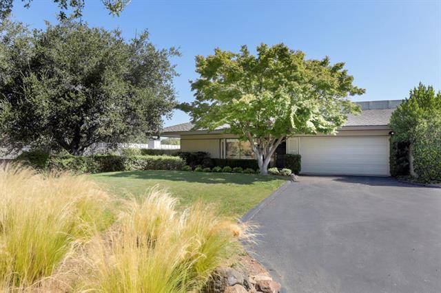
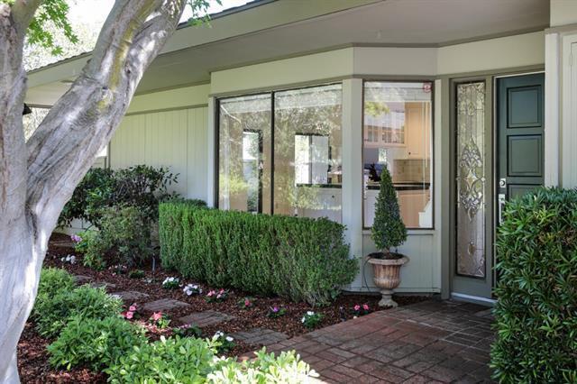
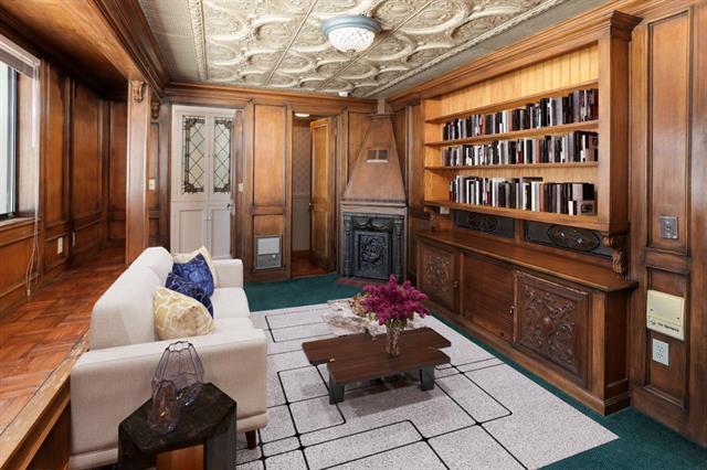
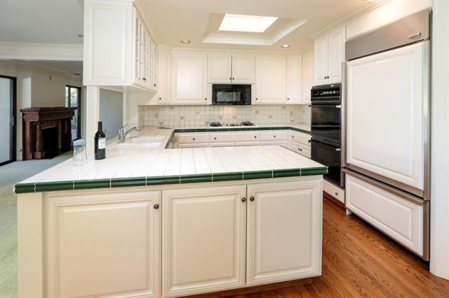
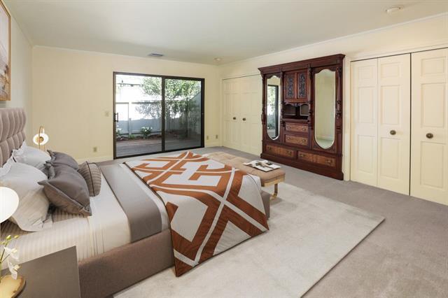
Welcome to this charming 2-bedroom, 2-bathroom home located in Los Altos. Spanning 1,840 sq ft on a minimum lot size of 2,703 sq ft, this residence offers ample space and comfort. The well-appointed kitchen is a highlight, featuring a gas cooktop, dishwasher, island, and refrigerator. The kitchen seamlessly flows into the family room, creating a perfect space for gatherings. The home is equipped with central air conditioning and central forced air gas heating, ensuring comfort year-round. Cozy up by the fireplace in the inviting living area, which also features carpet flooring throughout. For your convenience, laundry hookups are available. The property includes a dining area and a 2-car garage, providing plenty of storage and parking space. Located within the Los Altos Elementary School District, this home offers an excellent location in a sought-after community. Don't miss the opportunity to make this Los Altos gem your own!
47 Bay Tree Ln is a townhome located in Santa Clara County and the 94022 ZIP Code. This area is served by the Los Altos Elementary attendance zone.
* Price shown is base rent and may not include non-optional fees and utilities.
Price, availability, fees, and any applicable rent special are subject to change without notice.
* Square footage definitions vary. Displayed square footage is approximate.
Townhome Features
- Fireplace
- Pool
Fees and Policies
The fees below are based on community-supplied data and may exclude additional fees and utilities.
Contact
- Listed by Edward Graziani | Christie's International Real Estate Sereno
- Contact
-
Source
 MLSListings Inc.
Copyright © 2025 MLSListings Inc.
Location
Get Directions
Amenities
- Fireplace
- Pool
Los Altos likes to strike a balance between the urbanized atmosphere of the Bay Area and the more rural environment of the wide-open spaces bordering the city’s southwest side. While it is mainly a residential community, the downtown area surrounding Main Street is a walkable shopping and dining district with tree-lined streets and several public parks nearby. The crime rate is quite low and the local schools are among the highest-performing in the state. Palo Alto is right next door and San Jose just a few minutes down the road, giving Los Altos residents convenient access to Silicon Valley’s greatest amenities.
Learn more about living in Los Altos
Education
| Colleges & Universities | Distance | ||
|---|---|---|---|
| Colleges & Universities | Distance | ||
| Drive: | 4 min | 1.1 mi | |
| Drive: | 11 min | 4.4 mi | |
| Drive: | 12 min | 6.5 mi | |
| Drive: | 14 min | 7.1 mi |
47 Bay Tree Ln is within 4 minutes or 1.1 miles from Foothill Coll., Los Altos. It is also near Foothill College, Middlefield and Stanford University.
Schools

Public Elementary School
Grades K-5
367 Students
Nearby
Public Elementary School
Grades K-6
259 Students
Attendance Zone
Public Middle School
Grades 7-8
497 Students
Attendance Zone
Public High School
Grades 9-12
2,141 Students
Attendance Zone
Private Elementary & Middle School
Grades K-8
250 Students
Nearby
Private High School
Grades 9-12
1,776 Students
Nearby
School data provided by
 The GreatSchools Rating helps parents compare schools within a state based on a variety of school quality indicators and provides a helpful picture of how effectively each school serves all of its students. Ratings are on a scale of 1 (below average) to 10 (above average) and can include test scores, college readiness, academic progress, advanced courses, equity, discipline and attendance data. We also advise parents to visit schools, consider other information on school performance and programs, and consider family needs as part of the school selection process.
View GreatSchools Rating Methodology
Data provided by GreatSchools.org © 2025. All rights reserved.
View GreatSchools Rating Methodology
Data provided by GreatSchools.org © 2025. All rights reserved.
Transportation options available in Los Altos include Mountain View Station, located 3.8 miles from 47 Bay Tree Ln. 47 Bay Tree Ln is near Norman Y Mineta San Jose International, located 12.6 miles or 23 minutes away, and San Francisco International, located 28.2 miles or 39 minutes away.
| Transit / Subway | Distance | ||
|---|---|---|---|
| Transit / Subway | Distance | ||
| Drive: | 11 min | 3.8 mi | |
|
|
Drive: | 11 min | 3.8 mi |
|
|
Drive: | 13 min | 4.8 mi |
|
|
Drive: | 13 min | 5.1 mi |
| Drive: | 14 min | 5.9 mi |
| Commuter Rail | Distance | ||
|---|---|---|---|
| Commuter Rail | Distance | ||
| Drive: | 8 min | 3.5 mi | |
| Drive: | 11 min | 3.7 mi | |
| Drive: | 12 min | 3.9 mi | |
| Drive: | 13 min | 7.1 mi | |
| Drive: | 14 min | 7.4 mi |
| Airports | Distance | ||
|---|---|---|---|
| Airports | Distance | ||
|
Norman Y Mineta San Jose International
|
Drive: | 23 min | 12.6 mi |
|
San Francisco International
|
Drive: | 39 min | 28.2 mi |
Time and distance from 47 Bay Tree Ln.
| Shopping Centers | Distance | ||
|---|---|---|---|
| Shopping Centers | Distance | ||
| Drive: | 5 min | 1.9 mi | |
| Drive: | 7 min | 2.1 mi | |
| Drive: | 6 min | 2.3 mi |
47 Bay Tree Ln has 3 shopping centers within 2.3 miles, which is about a 6-minute drive. The miles and minutes will be for the farthest away property.
| Parks and Recreation | Distance | ||
|---|---|---|---|
| Parks and Recreation | Distance | ||
|
Redwood Grove
|
Drive: | 4 min | 1.1 mi |
|
Foothill College Observatory
|
Drive: | 4 min | 1.3 mi |
|
Byrne Preserve
|
Drive: | 7 min | 2.7 mi |
|
Rancho San Antonio Open Space Preserve
|
Drive: | 10 min | 3.7 mi |
|
Esther Clark Nature Preserve
|
Drive: | 8 min | 3.7 mi |
47 Bay Tree Ln has 5 parks within 3.7 miles, including Redwood Grove, Foothill College Observatory, and Byrne Preserve.
| Hospitals | Distance | ||
|---|---|---|---|
| Hospitals | Distance | ||
| Drive: | 8 min | 2.9 mi | |
| Drive: | 14 min | 8.5 mi | |
| Drive: | 15 min | 8.7 mi |
47 Bay Tree Ln has 3 hospitals within 8.7 miles, the nearest is El Camino Hospital which is 2.9 miles away and a 8 minute drive.
| Military Bases | Distance | ||
|---|---|---|---|
| Military Bases | Distance | ||
| Drive: | 17 min | 6.1 mi |
47 Bay Tree Ln is 6.1 miles and a 17 minute drive from Ames Research Center.
You May Also Like
Similar Rentals Nearby


What Are Walk Score®, Transit Score®, and Bike Score® Ratings?
Walk Score® measures the walkability of any address. Transit Score® measures access to public transit. Bike Score® measures the bikeability of any address.
What is a Sound Score Rating?
A Sound Score Rating aggregates noise caused by vehicle traffic, airplane traffic and local sources

47 Bay Tree Ln
Los Altos, CA 94022