

$2,950 / Month
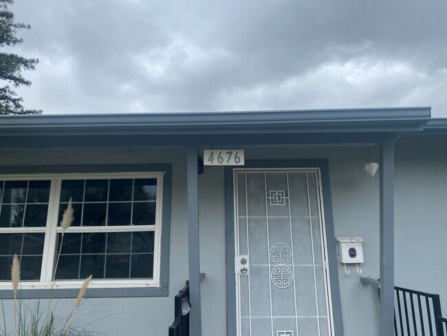
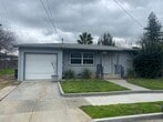
4676 Augustine St
Pleasanton, CA 94566
Today
Favorites
925-634-7774
-
Bedrooms
2
-
Bathrooms
1
-
Square Feet
791 sq ft
-
Available
Available Now
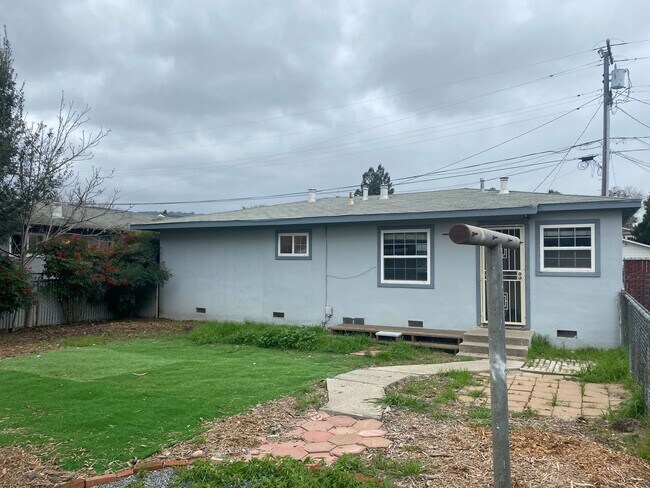
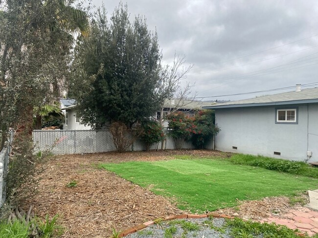
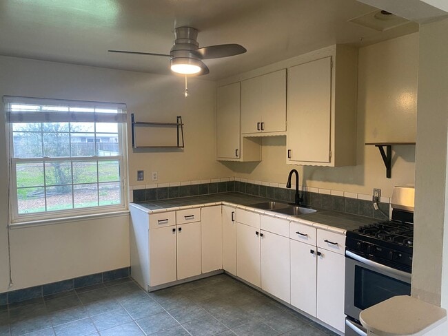
4676 Augustine St

Favorites
About This Home
$2,950 deposit,
Available Now
OPEN HOUSE Wednesday, June 4·4:45 – 5:15pm (SHARP!!!!) GREAT DOWNTOWN LOCATION..WALK EVERYWHERE...CUTE SINGLE STORY HOME WITH ATTACHED ONE CAR GARAGE..WITH AMPLY PARKING...2 BEDS/1 BATH WITH PRIVATE LAUNDRY..REFRIGERATOR/WASHER/DRYER INCLUDED.LAMINATE FLOORS AND TILE IN KITCHEN..MAKE THIS YOUR OWN DOLLHOUSE..
4676 Augustine St is a house located in Alameda County and the 94566 ZIP Code. This area is served by the Pleasanton Unified attendance zone.
* Price shown is base rent and may not include non-optional fees and utilities.
Price, availability, fees, and any applicable rent special are subject to change without notice.
* Square footage definitions vary. Displayed square footage is approximate.
Contact
- Listed by Marples & Associates, Inc. | Marples & Associates, Inc.
- Phone Number
- Contact
Location
Get Directions
The cities of Livermore, Dublin and Pleasanton form a loosely shaped triangle within California's Tri-Valley region, a cluster of three small valleys about 33 miles east of San Francisco and 35 miles northeast of San Jose. Known for its Mediterranean climate, rolling hills and historic vineyards, this once bucolic region now boasts three separate downtown areas, a bustling business community and some of the best wineries in the state.
At the eastern end of the region lies the city of Livermore. Once known as Livermores, Livermore Ranch and Nottingham, the city sits at the center of Livermore Valley, a historic region dotted with more than 5,000 acres of mostly family-owned vineyards. A pastoral neighborhood known for its charming yet functional hilltop windmills, Livermore hosts the internationally recognized and sometimes controversial center of scientific research, Lawrence Livermore National Laboratories.
Learn more about living in Dublin/Pleasanton/Livermore
Education
| Colleges & Universities | Distance | ||
|---|---|---|---|
| Colleges & Universities | Distance | ||
| Drive: | 16 min | 7.7 mi | |
| Drive: | 16 min | 8.0 mi | |
| Drive: | 18 min | 11.6 mi | |
| Drive: | 26 min | 17.2 mi |
4676 Augustine St is within 16 minutes or 7.7 miles from Diablo Valley Coll, San Ramon. It is also near Las Positas College and Ohlone College, Fremont Campus.
Schools


Public Elementary School
Grades K-5
497 Students
Nearby
Public Elementary School
Grades K-5
641 Students
Attendance Zone
Public Middle School
Grades 6-8
1,050 Students
Attendance Zone
Public High School
Grades 9-12
2,665 Students
Attendance Zone
Private Elementary School
Grades PK-5
Nearby
Private Elementary, Middle & High School
Grades K-12
23 Students
Nearby
School data provided by
 The GreatSchools Rating helps parents compare schools within a state based on a variety of school quality indicators and provides a helpful picture of how effectively each school serves all of its students. Ratings are on a scale of 1 (below average) to 10 (above average) and can include test scores, college readiness, academic progress, advanced courses, equity, discipline and attendance data. We also advise parents to visit schools, consider other information on school performance and programs, and consider family needs as part of the school selection process.
View GreatSchools Rating Methodology
Data provided by GreatSchools.org © 2025. All rights reserved.
View GreatSchools Rating Methodology
Data provided by GreatSchools.org © 2025. All rights reserved.
Transportation options available in Pleasanton include Dublin / Pleasanton, located 3.9 miles from 4676 Augustine St. 4676 Augustine St is near Metro Oakland International, located 23.6 miles or 31 minutes away, and Norman Y Mineta San Jose International, located 26.5 miles or 35 minutes away.
| Transit / Subway | Distance | ||
|---|---|---|---|
| Transit / Subway | Distance | ||
|
|
Drive: | 8 min | 3.9 mi |
|
|
Drive: | 8 min | 5.2 mi |
|
|
Drive: | 22 min | 13.9 mi |
|
|
Drive: | 22 min | 14.0 mi |
|
|
Drive: | 28 min | 15.8 mi |
| Commuter Rail | Distance | ||
|---|---|---|---|
| Commuter Rail | Distance | ||
| Walk: | 6 min | 0.4 mi | |
| Walk: | 7 min | 0.4 mi | |
| Drive: | 12 min | 6.7 mi | |
| Drive: | 13 min | 6.9 mi | |
| Drive: | 19 min | 10.2 mi |
| Airports | Distance | ||
|---|---|---|---|
| Airports | Distance | ||
|
Metro Oakland International
|
Drive: | 31 min | 23.6 mi |
|
Norman Y Mineta San Jose International
|
Drive: | 35 min | 26.5 mi |
Time and distance from 4676 Augustine St.
| Shopping Centers | Distance | ||
|---|---|---|---|
| Shopping Centers | Distance | ||
| Walk: | 12 min | 0.6 mi | |
| Walk: | 13 min | 0.7 mi | |
| Walk: | 16 min | 0.8 mi |
4676 Augustine St has 3 shopping centers within 0.8 mile, which is about a 16-minute walk. The miles and minutes will be for the farthest away property.
| Parks and Recreation | Distance | ||
|---|---|---|---|
| Parks and Recreation | Distance | ||
|
Shadow Cliffs Regional Recreation Area
|
Drive: | 8 min | 2.7 mi |
|
Dublin Hills Regional Parks
|
Drive: | 18 min | 8.0 mi |
|
Niles Canyon Railway
|
Drive: | 22 min | 12.9 mi |
|
Pleasanton Ridge Regional Park
|
Drive: | 22 min | 14.3 mi |
|
Garin/Dry Creek Pioneer Parks
|
Drive: | 28 min | 16.3 mi |
4676 Augustine St has 5 parks within 16.3 miles, including Shadow Cliffs Regional Recreation Area, Dublin Hills Regional Parks, and Pleasanton Ridge Regional Park.
| Hospitals | Distance | ||
|---|---|---|---|
| Hospitals | Distance | ||
| Drive: | 6 min | 2.6 mi | |
| Drive: | 17 min | 11.8 mi | |
| Drive: | 23 min | 14.3 mi |
4676 Augustine St has 3 hospitals within 14.3 miles, the nearest is Stanford Health Care - ValleyCare which is 2.6 miles away and a 6 minute drive.
| Military Bases | Distance | ||
|---|---|---|---|
| Military Bases | Distance | ||
| Drive: | 41 min | 29.3 mi |
4676 Augustine St is 29.3 miles and a 41 minute drive from Ames Research Center.
You May Also Like
Similar Rentals Nearby


What Are Walk Score®, Transit Score®, and Bike Score® Ratings?
Walk Score® measures the walkability of any address. Transit Score® measures access to public transit. Bike Score® measures the bikeability of any address.
What is a Sound Score Rating?
A Sound Score Rating aggregates noise caused by vehicle traffic, airplane traffic and local sources
4676 Augustine St
Pleasanton, CA 94566