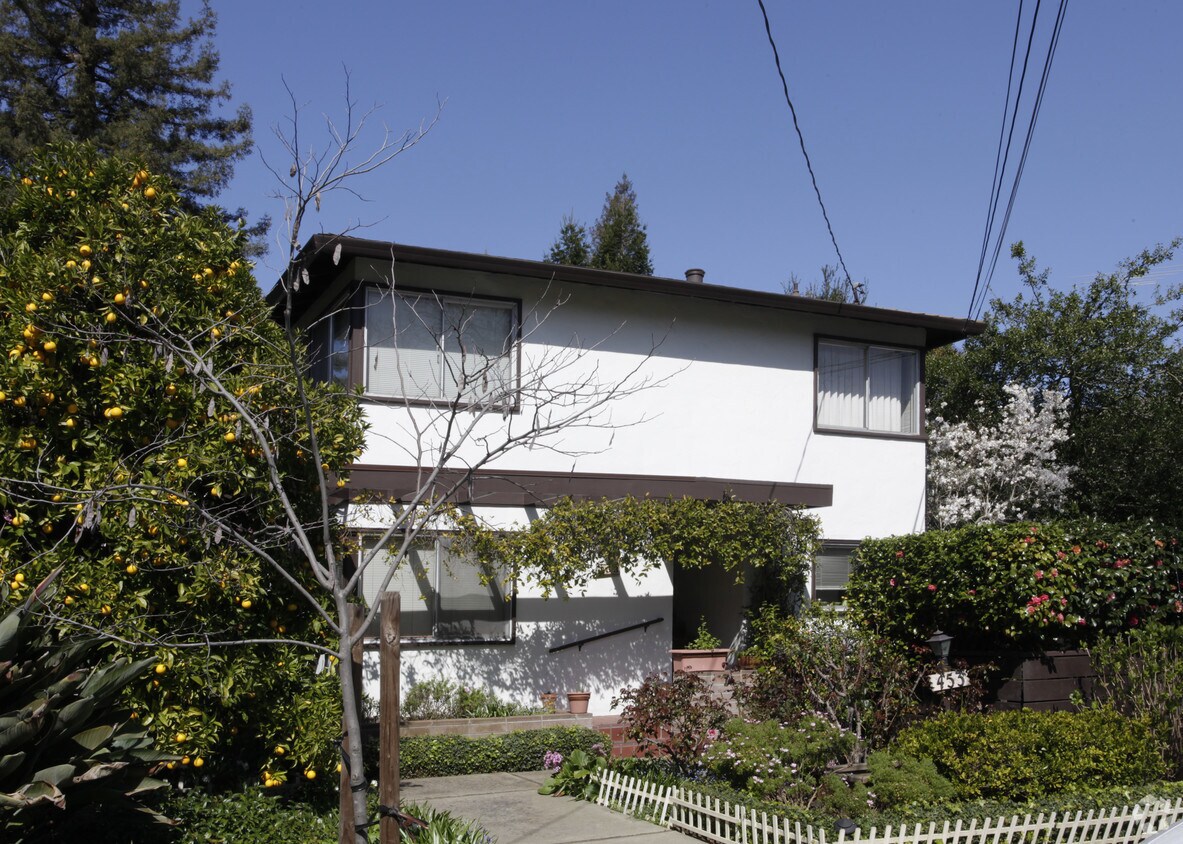
453 Hawthorne Ave
453 Hawthorne Ave,
Palo Alto,
CA
94301
2 Weeks Ago
Favorites
453 Hawthorne Ave
Favorites
Check Back Soon for Upcoming Availability
| Beds | Baths | Average SF | Availability |
|---|---|---|---|
| 2 Bedrooms 2 Bedrooms 2 Br | 1 Bath 1 Bath 1 Ba | 1,050 SF | Not Available |
| 3 Bedrooms 3 Bedrooms 3 Br | 2 Baths 2 Baths 2 Ba | 1,300 SF | Not Available |
Fees and Policies
Details
Property Information
-
Built in 1958
-
4 units/2 stories
About 453 Hawthorne Ave Palo Alto, CA 94301
Discover your new home at 453 Hawthorne Ave in Palo Alto, CA. This community is located in the Downtown Palo Alto area of Palo Alto. This community provides 2 to 3 bedroom floor plans. The leasing staff is excited to help you find your ideal place. It's time to find your new home. Contact or stop by 453 Hawthorne Ave to schedule a tour!
453 Hawthorne Ave is an apartment community located in Santa Clara County and the 94301 ZIP Code. This area is served by the Palo Alto Unified attendance zone.
Location
Get Directions
An outgoing vibe emanates from the Downtown North neighborhood. Downtown North provides an energy like no other in Palo Alto. Still, locals enjoy being part of a tight-knit community focused on safety, communication and most importantly: fun.
Palo Alto has one of the best public school systems in California, houses Stanford University, and has some of the most delicious dining and exciting shopping opportunities in the Bay Area. The placement of the city provides convenience for commuters to San Jose 24 miles to the Southeast or San Francisco 32 miles to the Northwest.
Learn more about living in Downtown Palo AltoBelow are rent ranges for similar nearby apartments
| Beds | Average Size | Lowest | Typical | Premium |
|---|---|---|---|---|
| Studio Studio Studio | 471 Sq Ft | $1,950 | $3,586 | $4,525 |
| 1 Bed 1 Bed 1 Bed | 637-640 Sq Ft | $3,290 | $4,063 | $5,294 |
| 2 Beds 2 Beds 2 Beds | 986 Sq Ft | $4,410 | $6,140 | $13,790 |
| 3 Beds 3 Beds 3 Beds | 1894 Sq Ft | $6,600 | $8,121 | $10,500 |
| 4 Beds 4 Beds 4 Beds | 3763 Sq Ft | $9,000 | $19,667 | $35,000 |
Education
| Colleges & Universities | Distance | ||
|---|---|---|---|
| Colleges & Universities | Distance | ||
| Drive: | 7 min | 2.3 mi | |
| Drive: | 9 min | 2.7 mi | |
| Drive: | 13 min | 5.9 mi | |
| Drive: | 17 min | 8.1 mi |
453 Hawthorne Ave is within 9 minutes or 2.7 miles from Stanford University. It is also near Menlo College and Foothill College, Middlefield.
Schools


Public Elementary School
Grades K-5
331 Students
Attendance Zone
Public Elementary School
Grades K-5
270 Students
Nearby
Public Elementary School
Grades K-5
367 Students
Nearby
Public Middle School
Grades 6-8
755 Students
Attendance Zone
Public High School
Grades 9-12
1,992 Students
Attendance Zone
Private Elementary, Middle & High School
Grades PK-12
247 Students
Nearby
Private Elementary & Middle School
Grades PK-8
Nearby
Private Middle & High School
Grades 7-12
Nearby
School data provided by
 The GreatSchools Rating helps parents compare schools within a state based on a variety of school quality indicators and provides a helpful picture of how effectively each school serves all of its students. Ratings are on a scale of 1 (below average) to 10 (above average) and can include test scores, college readiness, academic progress, advanced courses, equity, discipline and attendance data. We also advise parents to visit schools, consider other information on school performance and programs, and consider family needs as part of the school selection process.
View GreatSchools Rating Methodology
Data provided by GreatSchools.org © 2025. All rights reserved.
View GreatSchools Rating Methodology
Data provided by GreatSchools.org © 2025. All rights reserved.
Transportation options available in Palo Alto include Bayshore Nasa Station, located 8.2 miles from 453 Hawthorne Ave. 453 Hawthorne Ave is near Norman Y Mineta San Jose International, located 15.8 miles or 24 minutes away, and San Francisco International, located 19.9 miles or 29 minutes away.
| Transit / Subway | Distance | ||
|---|---|---|---|
| Transit / Subway | Distance | ||
| Drive: | 14 min | 8.2 mi | |
|
|
Drive: | 14 min | 8.4 mi |
| Drive: | 14 min | 8.6 mi | |
|
|
Drive: | 14 min | 8.7 mi |
|
|
Drive: | 15 min | 8.8 mi |
| Commuter Rail | Distance | ||
|---|---|---|---|
| Commuter Rail | Distance | ||
| Walk: | 14 min | 0.7 mi | |
| Drive: | 5 min | 1.7 mi | |
| Drive: | 6 min | 2.4 mi | |
| Drive: | 8 min | 3.0 mi | |
| Drive: | 13 min | 5.2 mi |
| Airports | Distance | ||
|---|---|---|---|
| Airports | Distance | ||
|
Norman Y Mineta San Jose International
|
Drive: | 24 min | 15.8 mi |
|
San Francisco International
|
Drive: | 29 min | 19.9 mi |
Time and distance from 453 Hawthorne Ave.
| Shopping Centers | Distance | ||
|---|---|---|---|
| Shopping Centers | Distance | ||
| Drive: | 4 min | 1.2 mi | |
| Drive: | 4 min | 1.2 mi | |
| Drive: | 5 min | 1.4 mi |
453 Hawthorne Ave has 3 shopping centers within 1.4 miles, which is about a 5-minute drive. The miles and minutes will be for the farthest away property.
| Parks and Recreation | Distance | ||
|---|---|---|---|
| Parks and Recreation | Distance | ||
|
Hopkins Creekside Park
|
Walk: | 11 min | 0.6 mi |
|
Seminary Oaks Park
|
Drive: | 4 min | 1.2 mi |
|
El Palo Alto Park
|
Drive: | 5 min | 1.4 mi |
|
Jack W. Lyle Park
|
Drive: | 4 min | 1.5 mi |
|
Burgess Park
|
Drive: | 5 min | 1.6 mi |
453 Hawthorne Ave has 5 parks within 1.6 miles, including El Palo Alto Park, Hopkins Creekside Park, and Burgess Park.
| Hospitals | Distance | ||
|---|---|---|---|
| Hospitals | Distance | ||
| Drive: | 6 min | 1.8 mi | |
| Drive: | 7 min | 2.4 mi | |
| Drive: | 12 min | 6.3 mi |
453 Hawthorne Ave has 3 hospitals within 6.3 miles, the nearest is Lucile Salter Packard Children's Hospital at Stanford which is 1.8 miles away and a 6 minute drive.
| Military Bases | Distance | ||
|---|---|---|---|
| Military Bases | Distance | ||
| Drive: | 17 min | 8.7 mi |
453 Hawthorne Ave is 8.7 miles and a 17 minute drive from Ames Research Center.
You May Also Like
What neighborhood is the property located in?
453 Hawthorne Ave Palo Alto, CA 94301 is in Downtown Palo Alto in the city of Palo Alto. Here you’ll find three shopping centers within 1.4 miles of the property. Five parks are within 1.6 miles, including El Palo Alto Park, Hopkins Creekside Park, and Burgess Park.
Similar Rentals Nearby


What Are Walk Score®, Transit Score®, and Bike Score® Ratings?
Walk Score® measures the walkability of any address. Transit Score® measures access to public transit. Bike Score® measures the bikeability of any address.
What is a Sound Score Rating?
A Sound Score Rating aggregates noise caused by vehicle traffic, airplane traffic and local sources

453 Hawthorne Ave
Palo Alto, CA 94301
Responded To This Review