$2,495
/ Month
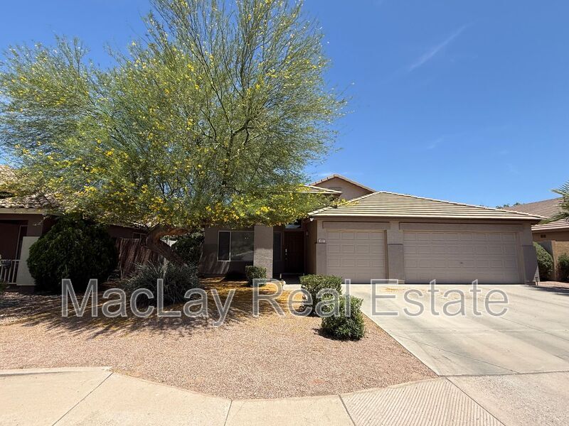
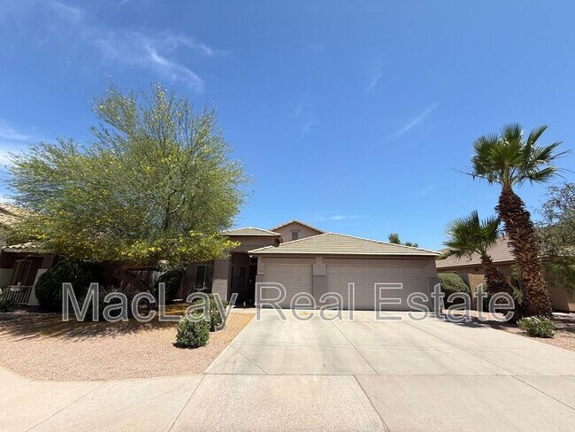
450 W Musket Pl
Chandler, AZ 85286
Favorites
928-916-5630
-
Bedrooms
4
-
Bathrooms
2
-
Square Feet
1,847 sq ft
-
Available
Available Jul 1
450 W Musket Pl

Favorites
About This Home
$2,495 deposit,
Available Jul 1
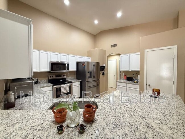
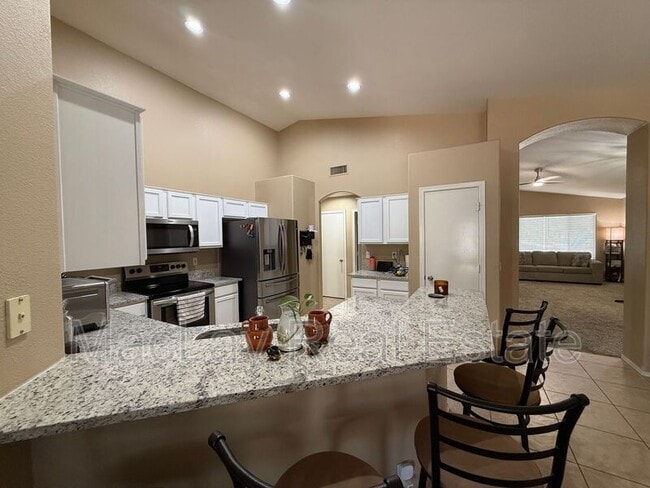
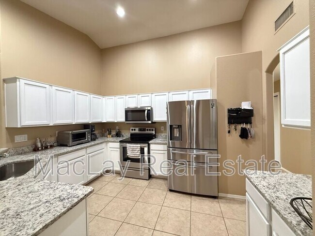
Discover this spacious 4-bedroom, 2-bath home in Chandler, AZ, featuring an open kitchen floorplan that flows into the living areas and separate living and family rooms for versatile use. The layout offers room for both everyday routines and entertaining, while the generous backyard provides outdoor space for gardening, play, or relaxation. Well-suited for a variety of lifestyles, this property combines practical interior spaces with a sizable exterior area in a convenient Chandler location. Move in costs: $2495 Rent plus admin. fee and resident benefits package $2495 Security Deposit $150 1x Admin. fee Total monthly rent is $2592.42 which includes a 1.5% admin. fee and resident benefits package Dogs okay with lessor approval Amenities: open kitchen floorplan, seperate living and family rooms, spacious back yard
450 W Musket Pl is a house located in Maricopa County and the 85286 ZIP Code. This area is served by the Chandler Unified District attendance zone.
* Price shown is base rent. Excludes user-selected optional fees and variable or usage-based fees and required charges due at or prior to move-in or at move-out. Price, availability, fees, and any applicable rent special are subject to change without notice.
* Square footage definitions vary. Displayed square footage is approximate.
Contact
- Listed by MacLay Real Estate
- Phone Number
- Contact
Location
Get Directions
Nestled between Downtown Chandler and the Gila River Indian Reservation, South Chandler is a sizeable suburban area brimming with all kinds of modern conveniences. South Chandler residents enjoy easy access to a slew of shopping centers and plazas, many of which are clustered along South Alma School Road and South Arizona Avenue.
South Chandler offers plenty of recreational opportunities at Tumbleweed Park, Chuparosa Park, Snedigar Recreation Center, and Paseo Vista Recreation Area. The expansive San Tan Mountains Regional Park is also just minutes away from South Chandler. A wide variety of golf and country clubs are located in South Chandler as well.
Learn more about living in South Chandler
Education
| Colleges & Universities | Distance | ||
|---|---|---|---|
| Colleges & Universities | Distance | ||
| Drive: | 10 min | 4.7 mi | |
| Drive: | 9 min | 5.0 mi | |
| Drive: | 18 min | 8.9 mi | |
| Drive: | 18 min | 11.4 mi |
450 W Musket Pl is within 10 minutes or 4.7 miles from Chandler-Gilbert C.C., Pecos. It is also near Chandler-Gilbert CC. Sun Lakes and Alverno College.
Schools


Public Elementary School
Grades PK-5
666 Students
Attendance Zone
Public Middle School
Grades 6-8
1,006 Students
Attendance Zone
Public Middle & High School
Grades 6-12
3,433 Students
Attendance Zone
Private Elementary School
Grades K-5
Nearby
Private Elementary & Middle School
Grades PK-8
195 Students
Nearby
Private Elementary, Middle & High School
Grades K-12
20 Students
Nearby
School data provided by
 The GreatSchools Rating helps parents compare schools within a state based on a variety of school quality indicators and provides a helpful picture of how effectively each school serves all of its students. Ratings are on a scale of 1 (below average) to 10 (above average) and can include test scores, college readiness, academic progress, advanced courses, equity, discipline and attendance data. We also advise parents to visit schools, consider other information on school performance and programs, and consider family needs as part of the school selection process.
View GreatSchools Rating Methodology
Data provided by GreatSchools.org © 2026. All rights reserved.
View GreatSchools Rating Methodology
Data provided by GreatSchools.org © 2026. All rights reserved.
Transportation options available in Chandler include Country Club/Main St, located 10.2 miles from 450 W Musket Pl. 450 W Musket Pl is near Phoenix-Mesa Gateway, located 12.6 miles or 20 minutes away, and Phoenix Sky Harbor International, located 20.3 miles or 29 minutes away.
| Transit / Subway | Distance | ||
|---|---|---|---|
| Transit / Subway | Distance | ||
|
|
Drive: | 18 min | 10.2 mi |
|
|
Drive: | 20 min | 10.7 mi |
|
|
Drive: | 22 min | 11.6 mi |
|
|
Drive: | 19 min | 13.3 mi |
|
|
Drive: | 20 min | 14.1 mi |
| Commuter Rail | Distance | ||
|---|---|---|---|
| Commuter Rail | Distance | ||
|
|
Drive: | 31 min | 22.8 mi |
| Airports | Distance | ||
|---|---|---|---|
| Airports | Distance | ||
|
Phoenix-Mesa Gateway
|
Drive: | 20 min | 12.6 mi |
|
Phoenix Sky Harbor International
|
Drive: | 29 min | 20.3 mi |
Getting Around
 What do Walkability, Transit, Drivability, and Bikeability mean?
Walkability measures the walking distance to day-to-day needs.
Transit measures access to public transportation.
Drivability measures congestion, parking availability, and access to major roads.
Bikeability measures the suitability for cycling.
How It Works
What do Walkability, Transit, Drivability, and Bikeability mean?
Walkability measures the walking distance to day-to-day needs.
Transit measures access to public transportation.
Drivability measures congestion, parking availability, and access to major roads.
Bikeability measures the suitability for cycling.
How It Works
Somewhat Walkable
Walkability
30
/ 100
Minimal Public Transit
Transit
0
/ 100
Exceptionally Drivable
Drivability
100
/ 100
Moderately Bikeable
Bikeability
60
/ 100
Scores provided by
-
Soundscore™
-
/ 100
Traffic
-Airport
-Businesses
-Scores provided by
HowLoud What is a Sound Score Rating? A Sound Score Rating aggregates noise caused by vehicle traffic, airplane traffic and local sources. How It WorksTime and distance from 450 W Musket Pl.
| Shopping Centers | Distance | ||
|---|---|---|---|
| Shopping Centers | Distance | ||
| Walk: | 15 min | 0.8 mi | |
| Drive: | 4 min | 1.4 mi |
450 W Musket Pl has 2 shopping centers within 1.4 miles, which is about a 4-minute drive. The miles and minutes will be for the farthest away property.
| Parks and Recreation | Distance | ||
|---|---|---|---|
| Parks and Recreation | Distance | ||
|
City of Chandler Environmental Education Center
|
Drive: | 14 min | 7.5 mi |
|
i.d.e.a. Museum
|
Drive: | 19 min | 10.4 mi |
|
Arizona Museum of Natural History
|
Drive: | 20 min | 10.8 mi |
|
Pecos Park
|
Drive: | 18 min | 11.5 mi |
|
Riparian Preserve at Water Ranch
|
Drive: | 20 min | 12.6 mi |
450 W Musket Pl has 5 parks within 12.6 miles, including City of Chandler Environmental Education Center, i.d.e.a. Museum, and Pecos Park.
| Hospitals | Distance | ||
|---|---|---|---|
| Hospitals | Distance | ||
| Drive: | 6 min | 3.2 mi | |
| Drive: | 10 min | 5.2 mi | |
| Drive: | 11 min | 7.0 mi |
450 W Musket Pl has 3 hospitals within 7.0 miles, the nearest is Chandler Regional Medical Center which is 3.2 miles away and a 6 minute drive.
| Military Bases | Distance | ||
|---|---|---|---|
| Military Bases | Distance | ||
| Drive: | 29 min | 21.1 mi | |
| Drive: | 58 min | 45.3 mi | |
| Drive: | 100 min | 81.6 mi |
450 W Musket Pl has 3 military bases within 81.6 miles, the nearest is Phoenix Sky Harbor Airport Air Guard Station which is 21.1 miles away and a 29 minute drive.
You May Also Like
Similar Rentals Nearby


What Are Walk Score®, Transit Score®, and Bike Score® Ratings?
Walk Score® measures the walkability of any address. Transit Score® measures access to public transit. Bike Score® measures the bikeability of any address.
What is a Sound Score Rating?
A Sound Score Rating aggregates noise caused by vehicle traffic, airplane traffic and local sources.

450 W Musket Pl
Chandler, AZ 85286