
$8,500
/ Month
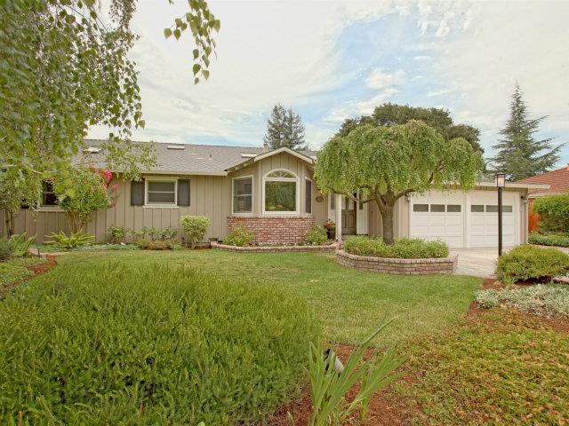
450 Panchita Way
Los Altos, CA 94022
2 Weeks Ago
|
Edit
Favorites
450 Panchita Way

Favorites
Check Back Soon for Upcoming Availability
| Beds | Baths | Average SF |
|---|---|---|
| 4 Bedrooms 4 Bedrooms 4 Br | 2.5 Baths 2.5 Baths 2.5 Ba | 2,493 SF |
About This Property
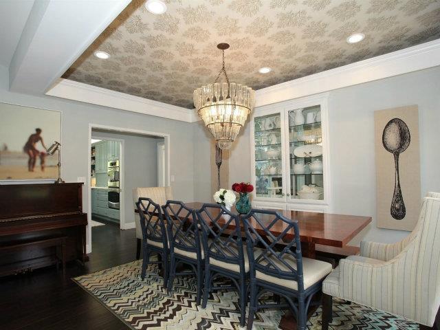
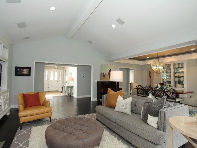
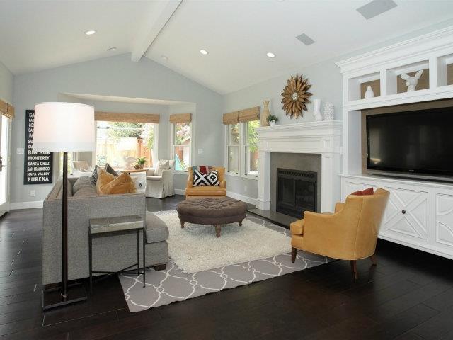
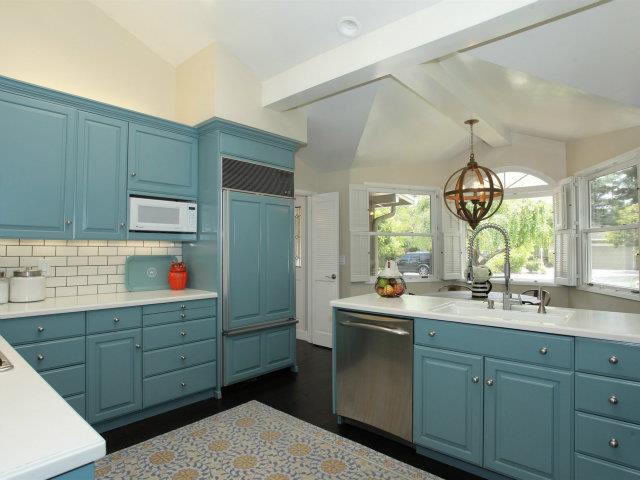
Updated 4 bedroom,2.5 bath spacious north Los Altos home. Vaulted ceiling in kitchen and living room. Large gourmet kitchen with Sub -Zero refrigerator and breakfast area. Coffered ceiling in dinging room, Hardwood floors, double pane windows. Living room with fireplace,Central Air conditioning. Master Suite with walk-in closet & walk-in shower. Washer, dryer and gardener included. Two car attached garage. Landscaped back yard with play structure. Quiet neighborhood. Walk to Los Altos High. Excellent Los Altos schools: Almond Elementary, Egan Intermediate and Los Altos High. Close to park, library, community center, shops, and downtown Los Altos.
450 Panchita Way is a house located in Santa Clara County and the 94022 ZIP Code. This area is served by the Los Altos Elementary School District attendance zone.
House Features
- Fireplace
450 Panchita Way,
Los Altos,
CA
94022
North Los Altos contains the city’s vibrant commercial centers. The many shops and eateries of Main Street are in the southern portion of North Los Altos, while the diverse restaurants and cafes of San Antonio Road are in the northern stretches near San Antonio Center.
Outside of these commercial areas, North Los Altos is predominantly residential, offering an array of apartments available for rent along tree-lined avenues. Many of the rentals in North Los Altos feature stunning mountain views, as well as close proximity to Mountain View, Foothill College, Stanford University, and Palo Alto. Getting around from North Los Altos is simple with access to El Camino Real, Interstate 280, and San Antonio Station.
Learn more about living in North Los AltosBelow are rent ranges for similar nearby apartments
| Beds | Average Size | Lowest | Typical | Premium |
|---|---|---|---|---|
| Studio Studio Studio | 488 Sq Ft | $2,250 | $2,598 | $3,095 |
| 1 Bed 1 Bed 1 Bed | 760-763 Sq Ft | $2,295 | $4,175 | $9,084 |
| 2 Beds 2 Beds 2 Beds | 1125-1133 Sq Ft | $2,695 | $5,040 | $9,939 |
| 3 Beds 3 Beds 3 Beds | 1546 Sq Ft | $4,441 | $6,733 | $11,000 |
| 4 Beds 4 Beds 4 Beds | 1450 Sq Ft | $5,970 | — | — |
Amenities
- Fireplace
Education
| Colleges & Universities | Distance | ||
|---|---|---|---|
| Colleges & Universities | Distance | ||
| Drive: | 7 min | 2.6 mi | |
| Drive: | 8 min | 2.9 mi | |
| Drive: | 13 min | 5.1 mi | |
| Drive: | 15 min | 7.7 mi |
450 Panchita Way is within 7 minutes or 2.6 miles from Foothill College, Middlefield. It is also near Foothill Coll., Los Altos and Stanford University.
Schools


Public Elementary School
Grades K-5
407 Students
Nearby
Public Elementary School
Grades K-5
354 Students
Attendance Zone
Public Middle School
Grades 6-8
517 Students
Attendance Zone
Public High School
Grades 9-12
2,170 Students
Attendance Zone
Private Elementary & Middle School
Grades PK-8
126 Students
Nearby
Private Elementary School
Grades K-5
Nearby
Private Elementary & Middle School
Grades K-8
Nearby
Private Middle & High School
Grades 6-12
Nearby
School data provided by
 The GreatSchools Rating helps parents compare schools within a state based on a variety of school quality indicators and provides a helpful picture of how effectively each school serves all of its students. Ratings are on a scale of 1 (below average) to 10 (above average) and can include test scores, college readiness, academic progress, advanced courses, equity, discipline and attendance data. We also advise parents to visit schools, consider other information on school performance and programs, and consider family needs as part of the school selection process.
View GreatSchools Rating Methodology
Data provided by GreatSchools.org © 2026. All rights reserved.
View GreatSchools Rating Methodology
Data provided by GreatSchools.org © 2026. All rights reserved.
Transportation options available in Los Altos include Mountain View Station, located 2.6 miles from 450 Panchita Way. 450 Panchita Way is near Norman Y Mineta San Jose International, located 12.4 miles or 20 minutes away, and San Francisco International, located 25.3 miles or 35 minutes away.
| Transit / Subway | Distance | ||
|---|---|---|---|
| Transit / Subway | Distance | ||
| Drive: | 6 min | 2.6 mi | |
|
|
Drive: | 9 min | 3.9 mi |
|
|
Drive: | 10 min | 4.6 mi |
| Drive: | 10 min | 4.8 mi | |
| Drive: | 12 min | 5.8 mi |
| Commuter Rail | Distance | ||
|---|---|---|---|
| Commuter Rail | Distance | ||
| Drive: | 4 min | 1.6 mi | |
| Drive: | 7 min | 2.7 mi | |
| Drive: | 10 min | 3.9 mi | |
| Drive: | 13 min | 5.5 mi | |
| Drive: | 12 min | 5.8 mi |
| Airports | Distance | ||
|---|---|---|---|
| Airports | Distance | ||
|
Norman Y Mineta San Jose International
|
Drive: | 20 min | 12.4 mi |
|
San Francisco International
|
Drive: | 35 min | 25.3 mi |
Walkability Near 450 Panchita Way Los Altos, CA 94022
Getting Around
 What do Walkability, Transit, Drivability, and Bikeability mean?
Walkability measures the walking distance to day-to-day needs.
Transit measures access to public transportation.
Drivability measures congestion, parking availability, and access to major roads.
Bikeability measures the suitability for cycling.
How It Works
What do Walkability, Transit, Drivability, and Bikeability mean?
Walkability measures the walking distance to day-to-day needs.
Transit measures access to public transportation.
Drivability measures congestion, parking availability, and access to major roads.
Bikeability measures the suitability for cycling.
How It Works
Fairly Walkable
Walkability
50
/ 100
Limited Public Transit
Transit
30
/ 100
Very Drivable
Drivability
80
/ 100
Fairly Bikeable
Bikeability
50
/ 100
Scores provided by
-
Soundscore™
-
/ 100
Traffic
-Airport
-Businesses
-Scores provided by
HowLoud What is a Sound Score Rating? A Sound Score Rating aggregates noise caused by vehicle traffic, airplane traffic and local sources. How It WorksTime and distance from 450 Panchita Way.
| Shopping Centers | Distance | ||
|---|---|---|---|
| Shopping Centers | Distance | ||
| Walk: | 19 min | 1.0 mi | |
| Walk: | 20 min | 1.1 mi | |
| Drive: | 3 min | 1.1 mi |
450 Panchita Way has 3 shopping centers within 1.1 miles, which is about a 3-minute drive. The miles and minutes will be for the farthest away property.
| Parks and Recreation | Distance | ||
|---|---|---|---|
| Parks and Recreation | Distance | ||
|
Redwood Grove
|
Drive: | 5 min | 1.8 mi |
|
Terman Park
|
Drive: | 7 min | 2.7 mi |
|
Foothill College Observatory
|
Drive: | 8 min | 3.2 mi |
|
Esther Clark Nature Preserve
|
Drive: | 7 min | 3.3 mi |
|
Bol Park
|
Drive: | 9 min | 3.5 mi |
450 Panchita Way has 5 parks within 3.5 miles, including Redwood Grove, Terman Park, and Esther Clark Nature Preserve.
| Hospitals | Distance | ||
|---|---|---|---|
| Hospitals | Distance | ||
| Drive: | 8 min | 3.4 mi | |
| Drive: | 14 min | 5.8 mi | |
| Drive: | 15 min | 6.8 mi |
450 Panchita Way has 3 hospitals within 6.8 miles, the nearest is El Camino Hospital which is 3.4 miles away and a 8 minute drive.
| Military Bases | Distance | ||
|---|---|---|---|
| Military Bases | Distance | ||
| Drive: | 13 min | 4.9 mi |
450 Panchita Way is 4.9 miles and a 13 minute drive from Ames Research Center.
You May Also Like
Similar Rentals Nearby


What Are Walk Score®, Transit Score®, and Bike Score® Ratings?
Walk Score® measures the walkability of any address. Transit Score® measures access to public transit. Bike Score® measures the bikeability of any address.
What is a Sound Score Rating?
A Sound Score Rating aggregates noise caused by vehicle traffic, airplane traffic and local sources.

450 Panchita Way
Los Altos, CA 94022