$6,000
/ Month
444 San Antonio Rd
Palo Alto, CA 94306
Today
Favorites
626-705-1160
-
Bedrooms
3
-
Bathrooms
3
-
Square Feet
1,826 sq ft
-
Available
Available Now
Highlights
- Primary Bedroom Suite
- Updated Kitchen
- Neighborhood Views
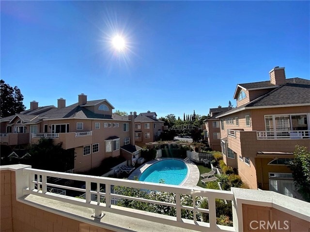
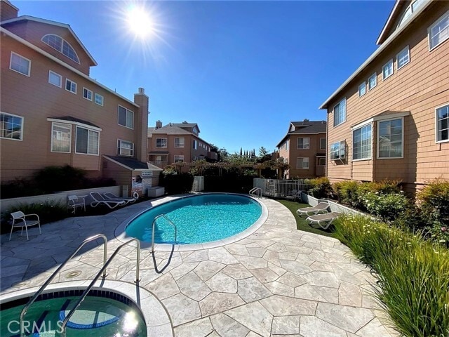
- Community Pool
- 2 Car Attached Garage
- Laundry Room
444 San Antonio Rd

Favorites
About This Home
12 Month Lease,
$6,000 deposit,
Available Now
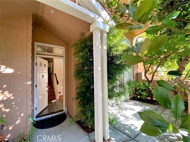
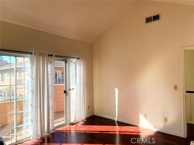
This charming 3 bedroom 2.5 baths is approximately 1826 sqft with an attached 2 car garage. Newer remodeled bath and updated shower rack. A newer EV charger installed in garage.. It has separate laundry room, ample storage space, 2 balconies and a front patio. The end unit home is located one of the best locations at the rear of the complex, overlooking the sparkling pool. This established and well care for complex has mature trees and gardens surrounding all units in a park-like setting. Fantastic Palo Alto school district. -Close distance to Restaurants, Whole Foods, Sprouts, Grocery Outlet, and Retail shops -Perfectly situated to companies such as VMware, Tesla, Facebook, Google, and Linkedin. MLS# AR25168781
444 San Antonio Rd is a townhome located in Santa Clara County and the 94306 ZIP Code. This area is served by the Palo Alto Unified attendance zone.
* Price shown is base rent. Excludes user-selected optional fees and variable or usage-based fees and required charges due at or prior to move-in or at move-out. Price, availability, fees, and any applicable rent special are subject to change without notice.
* Square footage definitions vary. Displayed square footage is approximate.
Home Details
Home Type
Townhome
Year Built
Built in 1988
Bedrooms and Bathrooms
Primary Bedroom Suite
2.5 Bathrooms
3 Bedrooms
Home Design
Entry on the 1st floor
Interior Spaces
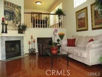
Living Room with Fireplace
1,826 Sq Ft Home
3-Story Property
Kitchen
Updated Kitchen
Laundry
Laundry Room
Listing and Financial Details
Security Deposit $6,000
12-Month Minimum Lease Term
Available 8/15/25
Legal Lot and Block 1 / 11
Tax Tract Number 8035
Assessor Parcel Number 14782034
Rent includes association dues, sewer, trash collection
Lot Details
897 Sq Ft Lot
1 Common Wall
Outdoor Features
Exterior Lighting
Parking
2 Car Attached Garage
Parking Available
Utilities
Central Heating and Cooling System
Views
Neighborhood Views
Community Details
Overview
48 Units
Property has a Home Owners Association
$350 HOA Transfer Fee
Recreation
Community Pool
Fees and Policies
The fees below are based on community-supplied data and may exclude additional fees and utilities.
- Parking
-
Garage--
-
Other--
Details
Utilities Included
-
Trash Removal
-
Sewer
Lease Options
-
12 Months
Contact
- Listed by Joshua Chao | Help-U-Sell Smart Realty
- Phone Number
- Contact
-
Source
 California Regional Multiple Listing Service
Copyright 2025 © California Regional MLS. All rights reserved.
Location
Get Directions
Amenities
- Air Conditioning
- Heating
- Fireplace
Expenses
Utilities Included
Trash Removal, Sewer
Included
Palo Alto is known as the birthplace of Silicon Valley and that unique heritage is proudly on display, with the Computer History Museum just down the street from Google’s world headquarters and countless other tech companies all over town. The restaurant scene rivals that of nearby San Francisco, with many small, independent eateries serving up some of the best food in the Bay Area.
With close proximity to the country’s tech center, it’s no surprise that Palo Alto apartments come with some of the most incredible amenities around. Residents also have access to dozens of options for outdoor recreation, including the gorgeous hiking and biking trails through the surrounding nature preserves, several golf courses, and easy access to San Francisco Bay. Bicycling is a popular mode of transportation around Palo Alto, with many bike-friendly routes around the city.
Palo Alto is famous as the home of Stanford University, and the campus is one of the most dominant landmarks in the area.
Learn more about living in Palo Alto
Education
| Colleges & Universities | Distance | ||
|---|---|---|---|
| Colleges & Universities | Distance | ||
| Walk: | 12 min | 0.6 mi | |
| Drive: | 12 min | 5.0 mi | |
| Drive: | 13 min | 5.1 mi | |
| Drive: | 17 min | 9.7 mi |
444 San Antonio Rd is within 12 minutes or 0.6 mile from Foothill College, Middlefield. It is also near Stanford University and Foothill Coll., Los Altos.
Schools


Public Elementary School
Grades K-5
403 Students
Attendance Zone
Public Elementary School
Grades K-5
367 Students
Nearby
Public Middle School
Grades 6-8
996 Students
Attendance Zone
Public High School
Grades 9-12
1,787 Students
Attendance Zone
Private Elementary & Middle School
Grades K-8
307 Students
Nearby
Private Elementary School
Grades PK-5
Nearby
Private Middle & High School
Grades 8-12
Nearby
School data provided by
 The GreatSchools Rating helps parents compare schools within a state based on a variety of school quality indicators and provides a helpful picture of how effectively each school serves all of its students. Ratings are on a scale of 1 (below average) to 10 (above average) and can include test scores, college readiness, academic progress, advanced courses, equity, discipline and attendance data. We also advise parents to visit schools, consider other information on school performance and programs, and consider family needs as part of the school selection process.
View GreatSchools Rating Methodology
Data provided by GreatSchools.org © 2025. All rights reserved.
View GreatSchools Rating Methodology
Data provided by GreatSchools.org © 2025. All rights reserved.
Transportation options available in Palo Alto include Mountain View Station, located 2.9 miles from 444 San Antonio Rd. 444 San Antonio Rd is near Norman Y Mineta San Jose International, located 11.1 miles or 16 minutes away, and San Francisco International, located 23.4 miles or 31 minutes away.
| Transit / Subway | Distance | ||
|---|---|---|---|
| Transit / Subway | Distance | ||
| Drive: | 6 min | 2.9 mi | |
|
|
Drive: | 6 min | 2.9 mi |
| Drive: | 6 min | 3.5 mi | |
|
|
Drive: | 7 min | 3.7 mi |
|
|
Drive: | 8 min | 4.1 mi |
| Commuter Rail | Distance | ||
|---|---|---|---|
| Commuter Rail | Distance | ||
| Drive: | 3 min | 1.5 mi | |
| Drive: | 8 min | 3.2 mi | |
| Drive: | 9 min | 3.4 mi | |
| Drive: | 8 min | 3.5 mi | |
| Drive: | 9 min | 3.8 mi |
| Airports | Distance | ||
|---|---|---|---|
| Airports | Distance | ||
|
Norman Y Mineta San Jose International
|
Drive: | 16 min | 11.1 mi |
|
San Francisco International
|
Drive: | 31 min | 23.4 mi |
Time and distance from 444 San Antonio Rd.
| Shopping Centers | Distance | ||
|---|---|---|---|
| Shopping Centers | Distance | ||
| Walk: | 13 min | 0.7 mi | |
| Walk: | 15 min | 0.8 mi | |
| Drive: | 4 min | 1.5 mi |
444 San Antonio Rd has 3 shopping centers within 1.5 miles, which is about a 4-minute walk. The miles and minutes will be for the farthest away property.
| Parks and Recreation | Distance | ||
|---|---|---|---|
| Parks and Recreation | Distance | ||
|
J. Pearce Mitchell Park
|
Drive: | 5 min | 1.4 mi |
|
Terman Park
|
Drive: | 7 min | 2.7 mi |
|
Stevens Creek Shoreline Nature Study Area
|
Drive: | 8 min | 2.9 mi |
|
Bol Park
|
Drive: | 9 min | 3.5 mi |
|
Esther Clark Nature Preserve
|
Drive: | 10 min | 3.7 mi |
444 San Antonio Rd has 5 parks within 3.7 miles, including J. Pearce Mitchell Park, Terman Park, and Bol Park.
| Hospitals | Distance | ||
|---|---|---|---|
| Hospitals | Distance | ||
| Drive: | 9 min | 5.1 mi | |
| Drive: | 14 min | 5.7 mi | |
| Drive: | 15 min | 6.2 mi |
444 San Antonio Rd has 3 hospitals within 6.2 miles, the nearest is El Camino Hospital which is 5.1 miles away and a 9 minute drive.
| Military Bases | Distance | ||
|---|---|---|---|
| Military Bases | Distance | ||
| Drive: | 10 min | 4.0 mi |
444 San Antonio Rd is 4.0 miles and a 10 minute drive from Ames Research Center.
You May Also Like
Similar Rentals Nearby


What Are Walk Score®, Transit Score®, and Bike Score® Ratings?
Walk Score® measures the walkability of any address. Transit Score® measures access to public transit. Bike Score® measures the bikeability of any address.
What is a Sound Score Rating?
A Sound Score Rating aggregates noise caused by vehicle traffic, airplane traffic and local sources

444 San Antonio Rd
Palo Alto, CA 94306