
$4,995
Total Monthly Price
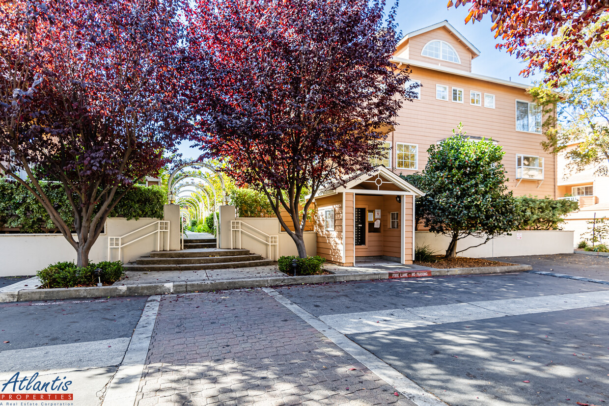
444 San Antonio Rd
Palo Alto, CA 94306
2 Weeks Ago
|
Edit
Favorites
444 San Antonio Rd

Favorites
Check Back Soon for Upcoming Availability
| Beds | Baths | Average SF |
|---|---|---|
| 3 Bedrooms 3 Bedrooms 3 Br | 2.5 Baths 2.5 Baths 2.5 Ba | 1,826 SF |
Fees and Policies
The fees listed below are community-provided and may exclude utilities or add-ons. All payments are made directly to the property and are non-refundable unless otherwise specified.
- Parking
-
Garage--
About This Property
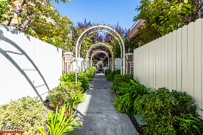
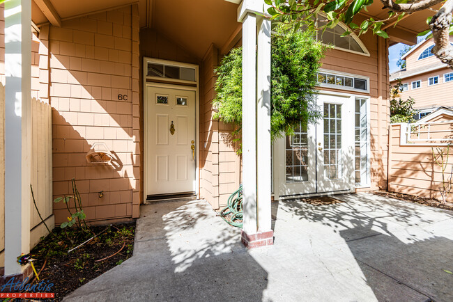
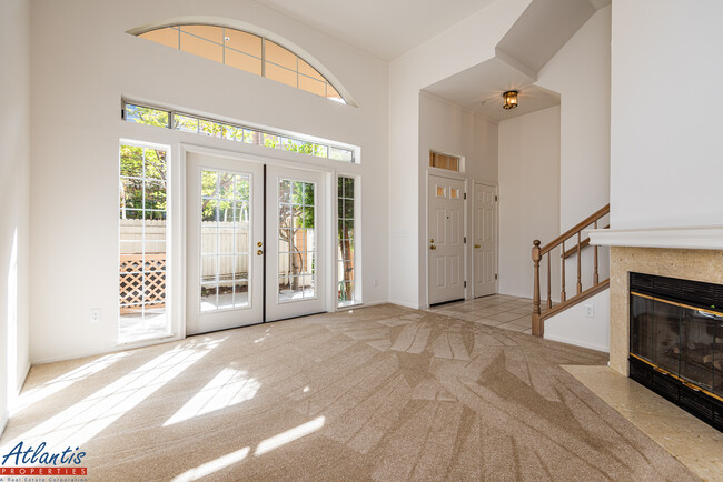
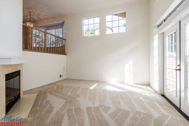
To view this property, please visit our public showing schedule on our website for available days and times. No appointment needed. - Monta Loma Neighborhood - Beautiful 3 Bedroom, 2.5 Bath Palo Alto Townhouse w/ Only One Shared Wall - Home Features Include Refinished Hardwood Flooring, New Carpet, New Interior Paint, Double-Pane Windows & 2" Blinds - Living Room w/ Vaulted Ceiling, Gas Fireplace & Front Patio Access - Formal Dining Room w/ Wet Bar - Kitchen/Family Includes Relaxing Balcony, Tile Counters, Refrigerator, Gas Range/Oven, Dishwasher & Built-In Microwave - Main Floor Half Bath - Top Floor Main Bedroom Suite Includes Balcony, Two Closets, Double Sinks, Soaking Tub & Shower Enclosure - Top Floor Also Includes Bedrooms Two, Three & Full Bathroom - Bottom Floor Includes Laundry Room w/ Washer/Dryer & Attached Two Car Garage w/ Ample Storage - Central Heat - Community Swimming Pool, Hot Tub & Guest Parking - Close Proximity To San Antonio Caltrain Station, Major Tech Companies, Safeway & Much More - Easy Access To Highways 85 & 101 - Highly Rated Schools: Fairmeadow Elementary School, Jane Lathrop Stanford Middle School, Henry M. Gunn High School (Tenant To Verify) - Tenant Pay Utilities - No Smoking - No Pets - Minimum One Year Lease - Renter's Insurance Required Rental Requirements: Household monthly gross income of at least three times the rent, good standing credit history & rental references. Please note, we can hold a property for a maximum of two weeks from the date of approval. DRE # 01498174
444 San Antonio Rd is a townhome located in Santa Clara County and the 94306 ZIP Code. This area is served by the Palo Alto Unified School District attendance zone.
Townhome Features
Washer/Dryer
Dishwasher
Hardwood Floors
Microwave
Refrigerator
Tub/Shower
Fireplace
Smoke Free
Indoor Features
- Washer/Dryer
- Heating
- Smoke Free
- Storage Space
- Double Vanities
- Tub/Shower
- Fireplace
Kitchen Features & Appliances
- Dishwasher
- Kitchen
- Microwave
- Oven
- Range
- Refrigerator
Model Details
- Hardwood Floors
- Carpet
- Dining Room
- Family Room
- Vaulted Ceiling
- Double Pane Windows
- Window Coverings
- Wet Bar
444 San Antonio Rd,
Palo Alto,
CA
94306
Living in Palo Alto places you in Silicon Valley, where historic neighborhoods complement the city's technological presence. Tree-lined streets wind through the community, which is anchored by Stanford University. University Avenue features local boutiques and restaurants housed in preserved historic buildings, while the Stanford Shopping Center offers high-end retail destinations. The city maintains 36 parks and preserves, including the Baylands Nature Preserve and Foothills Park, where residents enjoy hiking trails and outdoor activities. Palo Alto's infrastructure supports alternative transportation, with dedicated bike lanes throughout the city.
The rental market in Palo Alto reflects the area's popularity, with current average rents ranging from $2,634 for studios to $6,139 for four-bedroom homes. Recent trends show steady growth, with rent increases varying from 1.8% to 17% across different unit sizes over the past year.
Learn more about living in Palo AltoBelow are rent ranges for similar nearby apartments
Amenities
- Washer/Dryer
- Heating
- Smoke Free
- Storage Space
- Double Vanities
- Tub/Shower
- Fireplace
- Dishwasher
- Kitchen
- Microwave
- Oven
- Range
- Refrigerator
- Hardwood Floors
- Carpet
- Dining Room
- Family Room
- Vaulted Ceiling
- Double Pane Windows
- Window Coverings
- Wet Bar
- Laundry Facilities
- Balcony
- Patio
- Pool
Education
| Colleges & Universities | Distance | ||
|---|---|---|---|
| Colleges & Universities | Distance | ||
| Walk: | 12 min | 0.6 mi | |
| Drive: | 12 min | 5.1 mi | |
| Drive: | 14 min | 5.1 mi | |
| Drive: | 17 min | 9.7 mi |
444 San Antonio Rd is within 12 minutes or 0.6 mile from Foothill College, Middlefield. It is also near Stanford University and Foothill Coll., Los Altos.
Schools


Public Elementary School
Grades K-5
407 Students
Nearby
Public Elementary School
Grades K-5
425 Students
Attendance Zone
Public Middle School
Grades 6-8
1,002 Students
Attendance Zone
Public High School
Grades 9-12
1,643 Students
Attendance Zone
Private Elementary School
Grades PK-5
12 Students
Nearby
Private Elementary & Middle School
Grades PK-8
315 Students
Nearby
Private Middle & High School
Grades 6-12
Nearby
School data provided by
 The GreatSchools Rating helps parents compare schools within a state based on a variety of school quality indicators and provides a helpful picture of how effectively each school serves all of its students. Ratings are on a scale of 1 (below average) to 10 (above average) and can include test scores, college readiness, academic progress, advanced courses, equity, discipline and attendance data. We also advise parents to visit schools, consider other information on school performance and programs, and consider family needs as part of the school selection process.
View GreatSchools Rating Methodology
Data provided by GreatSchools.org © 2026. All rights reserved.
View GreatSchools Rating Methodology
Data provided by GreatSchools.org © 2026. All rights reserved.
Transportation options available in Palo Alto include Mountain View Station, located 2.9 miles from 444 San Antonio Rd. 444 San Antonio Rd is near Norman Y Mineta San Jose International, located 11.1 miles or 17 minutes away, and San Francisco International, located 23.4 miles or 31 minutes away.
| Transit / Subway | Distance | ||
|---|---|---|---|
| Transit / Subway | Distance | ||
| Drive: | 6 min | 2.9 mi | |
| Drive: | 7 min | 3.6 mi | |
|
|
Drive: | 8 min | 4.2 mi |
|
|
Drive: | 8 min | 4.2 mi |
| Drive: | 8 min | 4.5 mi |
| Commuter Rail | Distance | ||
|---|---|---|---|
| Commuter Rail | Distance | ||
| Drive: | 4 min | 1.5 mi | |
| Drive: | 8 min | 3.3 mi | |
| Drive: | 9 min | 3.8 mi | |
| Drive: | 12 min | 5.0 mi | |
| Drive: | 12 min | 6.4 mi |
| Airports | Distance | ||
|---|---|---|---|
| Airports | Distance | ||
|
Norman Y Mineta San Jose International
|
Drive: | 17 min | 11.1 mi |
|
San Francisco International
|
Drive: | 31 min | 23.4 mi |
Walkability Near 444 San Antonio Rd Palo Alto, CA 94306
Getting Around
 What do Walkability, Transit, Drivability, and Bikeability mean?
Walkability measures the walking distance to day-to-day needs.
Transit measures access to public transportation.
Drivability measures congestion, parking availability, and access to major roads.
Bikeability measures the suitability for cycling.
How It Works
What do Walkability, Transit, Drivability, and Bikeability mean?
Walkability measures the walking distance to day-to-day needs.
Transit measures access to public transportation.
Drivability measures congestion, parking availability, and access to major roads.
Bikeability measures the suitability for cycling.
How It Works
Fairly Walkable
Walkability
50
/ 100
Good Public Transit
Transit
60
/ 100
Exceptionally Drivable
Drivability
100
/ 100
Very Bikeable
Bikeability
80
/ 100
Scores provided by
Active
Soundscore™
71
/ 100
Traffic
BusyAirport
CalmBusinesses
ActiveScores provided by
HowLoud What is a Sound Score Rating? A Sound Score Rating aggregates noise caused by vehicle traffic, airplane traffic and local sources. How It WorksTime and distance from 444 San Antonio Rd.
| Shopping Centers | Distance | ||
|---|---|---|---|
| Shopping Centers | Distance | ||
| Walk: | 14 min | 0.7 mi | |
| Walk: | 15 min | 0.8 mi | |
| Drive: | 4 min | 1.5 mi |
444 San Antonio Rd has 3 shopping centers within 1.5 miles, which is about a 4-minute drive. The miles and minutes will be for the farthest away property.
| Parks and Recreation | Distance | ||
|---|---|---|---|
| Parks and Recreation | Distance | ||
|
J. Pearce Mitchell Park
|
Drive: | 5 min | 1.5 mi |
|
Terman Park
|
Drive: | 8 min | 2.7 mi |
|
Stevens Creek Shoreline Nature Study Area
|
Drive: | 9 min | 3.0 mi |
|
Bol Park
|
Drive: | 9 min | 3.5 mi |
|
Esther Clark Nature Preserve
|
Drive: | 10 min | 3.7 mi |
444 San Antonio Rd has 5 parks within 3.7 miles, including J. Pearce Mitchell Park, Terman Park, and Bol Park.
| Hospitals | Distance | ||
|---|---|---|---|
| Hospitals | Distance | ||
| Drive: | 9 min | 5.1 mi | |
| Drive: | 14 min | 5.7 mi | |
| Drive: | 16 min | 6.2 mi |
444 San Antonio Rd has 3 hospitals within 6.2 miles, the nearest is El Camino Hospital which is 5.1 miles away and a 9 minute drive.
| Military Bases | Distance | ||
|---|---|---|---|
| Military Bases | Distance | ||
| Drive: | 10 min | 4.0 mi |
444 San Antonio Rd is 4.0 miles and a 10 minute drive from Ames Research Center.
You May Also Like
Similar Rentals Nearby


What Are Walk Score®, Transit Score®, and Bike Score® Ratings?
Walk Score® measures the walkability of any address. Transit Score® measures access to public transit. Bike Score® measures the bikeability of any address.
What is a Sound Score Rating?
A Sound Score Rating aggregates noise caused by vehicle traffic, airplane traffic and local sources.
444 San Antonio Rd
Palo Alto, CA 94306