


$4,325
/ Month
4388 El Camino Real
Los Altos, CA 94022
Today
|
Edit
Favorites
-
Bedrooms
2
-
Bathrooms
2
-
Square Feet
1,200 sq ft
-
Available
Available Now
Highlights
- Private Pool
- Gated Community
- Wood Flooring
- Community Pool
- Subterranean Parking
- Breakfast Bar
4388 El Camino Real

Favorites
About This Home
Available Now
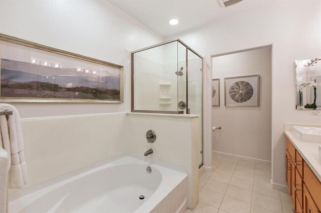
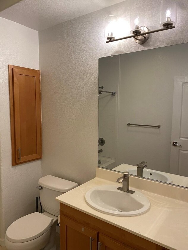
Luxury condo in the famous Peninsula Real community. This unit has a quiet setting, in the middle of the complex away from El Camino has 2 bedrooms, 2 bathrooms with a private yard/patio. Peninsula Real is a gated community with secured unground parking. This unit has 2 assigned parking spaces and a dedicated storage room. Inside the unit, you will find gleaming wood floors, top-of-line kitchen appliances, and luxurious primary suite with spa-like bath. The 2nd bedroom is just as generous in size has a hall bath to enjoy. In-unit laundry closet hosting full size side-by-side washer and dryer. This community offers mature landscaping and a sparkling pool. Monthly rent includes cold water, hot water and trash. property is virtually staged for conceptual purpose
4388 El Camino Real is a condo located in Santa Clara County and the 94022 ZIP Code.
* Price shown is base rent. Excludes user-selected optional fees and variable or usage-based fees and required charges due at or prior to move-in or at move-out. Price, availability, fees, and any applicable rent special are subject to change without notice.
* Square footage definitions vary. Displayed square footage is approximate.
Home Details
Bedrooms and Bathrooms
2 Full Bathrooms
2 Bedrooms
Flooring
Wood
Tile
Home Design
Apartment
Interior Spaces
Dining Area
1,200 Sq Ft Home
1-Story Property
Kitchen
Breakfast Bar
Gas Cooktop
Microwave
Dishwasher
Laundry
Washer and Dryer
Listing and Financial Details
Security Deposit $4,325
Property Available on 10/31/25
12-Month Minimum Lease Term
Rent includes association fees, hot water, trash removal, water
Parking
Subterranean Parking
Guest Parking
2 Car Garage
Garage Door Opener
Pool
Private Pool
Utilities
Forced Air Heating and Cooling System
Community Details
Amenities
Community Storage Space
Overview
Property has a Home Owners Association
1,200 Sq Ft Building
Pet Policy
Limit on the number of pets
Recreation
Community Pool
Security
Gated Community

Pennisula Real
78 Units
3 Stories
Built in 2009
99,020 Sq Ft
Peninsula Real, completed in 2009, stands as a contemporary residential complex in the vibrant Los Altos neighborhood. This 3-story condominium building houses 78 units, offering a blend of urban convenience and suburban tranquility. With its prime location and thoughtful design, Peninsula Real caters to those seeking a balanced lifestyle in Silicon Valley's sought-after community.
Learn more about Pennisula RealContact
- Listed by Julie Lau | Coldwell Banker Realty
- Contact
-
Source
 MLSListings Inc.
Copyright © 2025 MLSListings Inc.
Location
Get Directions
Amenities
- Pool
North Los Altos contains the city’s vibrant commercial centers. The many shops and eateries of Main Street are in the southern portion of North Los Altos, while the diverse restaurants and cafes of San Antonio Road are in the northern stretches near San Antonio Center.
Outside of these commercial areas, North Los Altos is predominantly residential, offering an array of apartments available for rent along tree-lined avenues. Many of the rentals in North Los Altos feature stunning mountain views, as well as close proximity to Mountain View, Foothill College, Stanford University, and Palo Alto. Getting around from North Los Altos is simple with access to El Camino Real, Interstate 280, and San Antonio Station.
Learn more about living in North Los Altos
Education
| Colleges & Universities | Distance | ||
|---|---|---|---|
| Colleges & Universities | Distance | ||
| Drive: | 5 min | 1.9 mi | |
| Drive: | 10 min | 3.7 mi | |
| Drive: | 9 min | 3.9 mi | |
| Drive: | 14 min | 5.9 mi |
4388 El Camino Real is within 5 minutes or 1.9 miles from Foothill College, Middlefield. It is also near Stanford University and Foothill Coll., Los Altos.
Transportation options available in Los Altos include Mountain View Station, located 2.8 miles from 4388 El Camino Real. 4388 El Camino Real is near Norman Y Mineta San Jose International, located 12.3 miles or 19 minutes away, and San Francisco International, located 24.6 miles or 34 minutes away.
| Transit / Subway | Distance | ||
|---|---|---|---|
| Transit / Subway | Distance | ||
| Drive: | 5 min | 2.8 mi | |
|
|
Drive: | 5 min | 2.8 mi |
|
|
Drive: | 8 min | 4.1 mi |
| Drive: | 9 min | 4.8 mi | |
|
|
Drive: | 10 min | 4.8 mi |
| Commuter Rail | Distance | ||
|---|---|---|---|
| Commuter Rail | Distance | ||
| Walk: | 19 min | 1.0 mi | |
| Drive: | 6 min | 2.6 mi | |
| Drive: | 7 min | 2.8 mi | |
| Drive: | 7 min | 3.0 mi | |
| Drive: | 8 min | 3.2 mi |
| Airports | Distance | ||
|---|---|---|---|
| Airports | Distance | ||
|
Norman Y Mineta San Jose International
|
Drive: | 19 min | 12.3 mi |
|
San Francisco International
|
Drive: | 34 min | 24.6 mi |
Time and distance from 4388 El Camino Real.
| Shopping Centers | Distance | ||
|---|---|---|---|
| Shopping Centers | Distance | ||
| Walk: | 2 min | 0.1 mi | |
| Walk: | 7 min | 0.4 mi | |
| Walk: | 11 min | 0.6 mi |
4388 El Camino Real has 3 shopping centers within 0.6 mile, which is about a 11-minute walk. The miles and minutes will be for the farthest away property.
| Parks and Recreation | Distance | ||
|---|---|---|---|
| Parks and Recreation | Distance | ||
|
Terman Park
|
Drive: | 4 min | 1.3 mi |
|
J. Pearce Mitchell Park
|
Drive: | 6 min | 1.9 mi |
|
Bol Park
|
Drive: | 5 min | 2.2 mi |
|
Esther Clark Nature Preserve
|
Drive: | 6 min | 2.3 mi |
|
Redwood Grove
|
Drive: | 7 min | 2.8 mi |
4388 El Camino Real has 5 parks within 2.8 miles, including Terman Park, Bol Park, and J. Pearce Mitchell Park.
| Hospitals | Distance | ||
|---|---|---|---|
| Hospitals | Distance | ||
| Drive: | 8 min | 3.7 mi | |
| Drive: | 11 min | 4.4 mi | |
| Drive: | 12 min | 4.9 mi |
4388 El Camino Real has 3 hospitals within 4.9 miles, the nearest is El Camino Hospital which is 3.7 miles away and a 8 minute drive.
| Military Bases | Distance | ||
|---|---|---|---|
| Military Bases | Distance | ||
| Drive: | 12 min | 5.1 mi |
4388 El Camino Real is 5.1 miles and a 12 minute drive from Ames Research Center.
You May Also Like
Similar Rentals Nearby


What Are Walk Score®, Transit Score®, and Bike Score® Ratings?
Walk Score® measures the walkability of any address. Transit Score® measures access to public transit. Bike Score® measures the bikeability of any address.
What is a Sound Score Rating?
A Sound Score Rating aggregates noise caused by vehicle traffic, airplane traffic and local sources
4388 El Camino Real
Los Altos, CA 94022