4388 El Camino Real
4388 El Camino Real,
Los Altos,
CA
94022
2 Weeks Ago
Favorites
4388 El Camino Real

Favorites
Check Back Soon for Upcoming Availability
Fees and Policies
The fees below are based on community-supplied data and may exclude additional fees and utilities.
- Parking
-
Covered--
Details
Utilities Included
-
Water
-
Trash Removal
-
Sewer
Lease Options
-
12 Months
About 4388 El Camino Real Los Altos, CA 94022
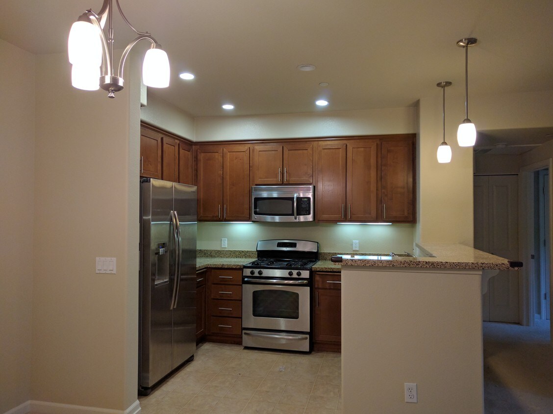
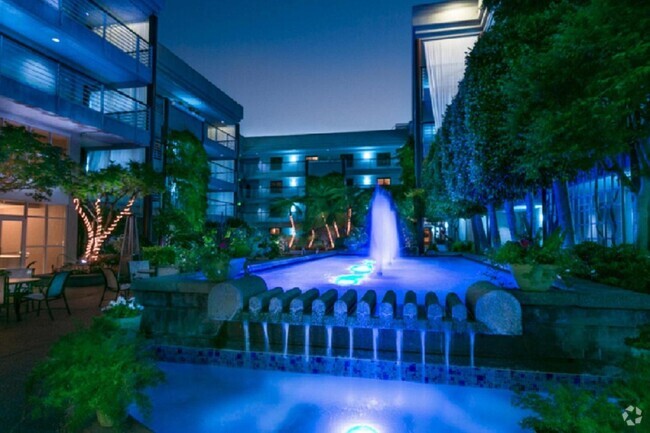
Beautiful 2bedroom/2bath Peninsula Real Condo Los Altos Overlooking the pool in the beautiful Peninsula Real community, this 2 bedroom/2bath condo is on the second floor and was built in 2009. This tranquil community is close to Whole Foods, San Antonio Shopping Center, and highway 101 and 280. Award winning Los Altos schools. One car parking spot under covered garage. Available now.
4388 El Camino Real is a condo located in Santa Clara County and the 94022 ZIP Code. This area is served by the Los Altos Elementary attendance zone.
Condo Features
Washer/Dryer
Air Conditioning
Dishwasher
Smoke Free
- Washer/Dryer
- Air Conditioning
- Smoke Free
- Dishwasher
- Pool
- Gated

Pennisula Real
78 Units
3 Stories
Built in 2009
99,020 Sq Ft
Peninsula Real, completed in 2009, stands as a contemporary residential complex in the vibrant Los Altos neighborhood. This 3-story condominium building houses 78 units, offering a blend of urban convenience and suburban tranquility. With its prime location and thoughtful design, Peninsula Real caters to those seeking a balanced lifestyle in Silicon Valley's sought-after community.
Learn more about Pennisula Real
Location
Get Directions
North Los Altos contains the city’s vibrant commercial centers. The many shops and eateries of Main Street are in the southern portion of North Los Altos, while the diverse restaurants and cafes of San Antonio Road are in the northern stretches near San Antonio Center.
Outside of these commercial areas, North Los Altos is predominantly residential, offering an array of apartments available for rent along tree-lined avenues. Many of the rentals in North Los Altos feature stunning mountain views, as well as close proximity to Mountain View, Foothill College, Stanford University, and Palo Alto. Getting around from North Los Altos is simple with access to El Camino Real, Interstate 280, and San Antonio Station.
Learn more about living in North Los AltosBelow are rent ranges for similar nearby apartments
Amenities
- Washer/Dryer
- Air Conditioning
- Smoke Free
- Dishwasher
- Gated
- Pool
Expenses
Utilities Included
Water, Trash Removal, Sewer
Included
Education
| Colleges & Universities | Distance | ||
|---|---|---|---|
| Colleges & Universities | Distance | ||
| Drive: | 5 min | 1.9 mi | |
| Drive: | 10 min | 3.8 mi | |
| Drive: | 9 min | 3.8 mi | |
| Drive: | 14 min | 6.0 mi |
4388 El Camino Real is within 5 minutes or 1.9 miles from Foothill College, Middlefield. It is also near Stanford University and Foothill Coll., Los Altos.
Schools

Public Elementary School
Grades K-5
367 Students
Nearby
Public Elementary School
Grades K-6
385 Students
Attendance Zone
Public Middle School
Grades 7-8
497 Students
Attendance Zone
Public High School
Grades 9-12
2,141 Students
Attendance Zone
Private Elementary School
Grades PK-5
Nearby
Private Elementary & Middle School
Grades K-8
268 Students
Nearby
Private Middle & High School
Grades 6-12
140 Students
Nearby
School data provided by
 The GreatSchools Rating helps parents compare schools within a state based on a variety of school quality indicators and provides a helpful picture of how effectively each school serves all of its students. Ratings are on a scale of 1 (below average) to 10 (above average) and can include test scores, college readiness, academic progress, advanced courses, equity, discipline and attendance data. We also advise parents to visit schools, consider other information on school performance and programs, and consider family needs as part of the school selection process.
View GreatSchools Rating Methodology
View GreatSchools Rating Methodology
Transportation options available in Los Altos include Mountain View Station, located 2.8 miles from 4388 El Camino Real. 4388 El Camino Real is near Norman Y Mineta San Jose International, located 12.3 miles or 19 minutes away, and San Francisco International, located 24.6 miles or 34 minutes away.
| Transit / Subway | Distance | ||
|---|---|---|---|
| Transit / Subway | Distance | ||
|
|
Drive: | 5 min | 2.8 mi |
|
|
Drive: | 8 min | 4.1 mi |
|
|
Drive: | 10 min | 4.7 mi |
|
Bayshore/Nasa Station
|
Drive: | 10 min | 4.8 mi |
|
|
Drive: | 11 min | 5.7 mi |
| Commuter Rail | Distance | ||
|---|---|---|---|
| Commuter Rail | Distance | ||
| Walk: | 18 min | 1.0 mi | |
| Drive: | 7 min | 2.9 mi | |
| Drive: | 8 min | 3.1 mi | |
| Drive: | 10 min | 4.2 mi | |
| Drive: | 12 min | 6.0 mi |
| Airports | Distance | ||
|---|---|---|---|
| Airports | Distance | ||
|
Norman Y Mineta San Jose International
|
Drive: | 19 min | 12.3 mi |
|
San Francisco International
|
Drive: | 34 min | 24.6 mi |
Time and distance from 4388 El Camino Real.
| Shopping Centers | Distance | ||
|---|---|---|---|
| Shopping Centers | Distance | ||
| Walk: | 4 min | 0.2 mi | |
| Walk: | 7 min | 0.4 mi | |
| Walk: | 10 min | 0.5 mi |
4388 El Camino Real has 3 shopping centers within 0.5 mile, which is about a 10-minute walk. The miles and minutes will be for the farthest away property.
| Parks and Recreation | Distance | ||
|---|---|---|---|
| Parks and Recreation | Distance | ||
|
Terman Park
|
Drive: | 4 min | 1.4 mi |
|
J. Pearce Mitchell Park
|
Drive: | 6 min | 2.0 mi |
|
Bol Park
|
Drive: | 6 min | 2.2 mi |
|
Esther Clark Nature Preserve
|
Drive: | 7 min | 2.4 mi |
|
Redwood Grove
|
Drive: | 7 min | 2.7 mi |
4388 El Camino Real has 5 parks within 2.7 miles, including Terman Park, Bol Park, and J. Pearce Mitchell Park.
| Hospitals | Distance | ||
|---|---|---|---|
| Hospitals | Distance | ||
| Drive: | 8 min | 3.6 mi | |
| Drive: | 11 min | 4.5 mi | |
| Drive: | 13 min | 5.0 mi |
4388 El Camino Real has 3 hospitals within 5.0 miles, the nearest is El Camino Hospital which is 3.6 miles away and a 8 minute drive.
| Military Bases | Distance | ||
|---|---|---|---|
| Military Bases | Distance | ||
| Drive: | 12 min | 5.1 mi |
4388 El Camino Real is 5.1 miles and a 12 minute drive from Ames Research Center.
You May Also Like
Similar Rentals Nearby


What Are Walk Score®, Transit Score®, and Bike Score® Ratings?
Walk Score® measures the walkability of any address. Transit Score® measures access to public transit. Bike Score® measures the bikeability of any address.
What is a Sound Score Rating?
A Sound Score Rating aggregates noise caused by vehicle traffic, airplane traffic and local sources