
$1,400 / Month
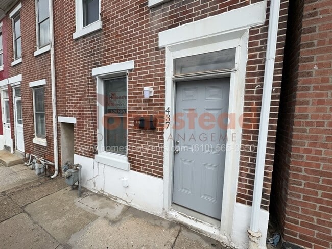
437 E Airy St
Norristown, PA 19401
Today
Favorites
-
Bedrooms
2
-
Bathrooms
1
-
Square Feet
--
437 E Airy St

Favorites
About This Home
$1,400 deposit
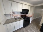
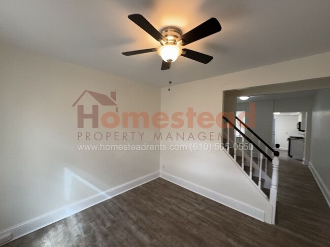
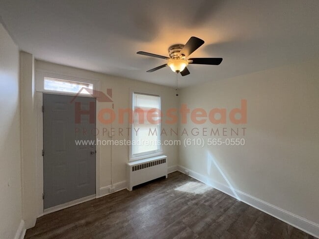
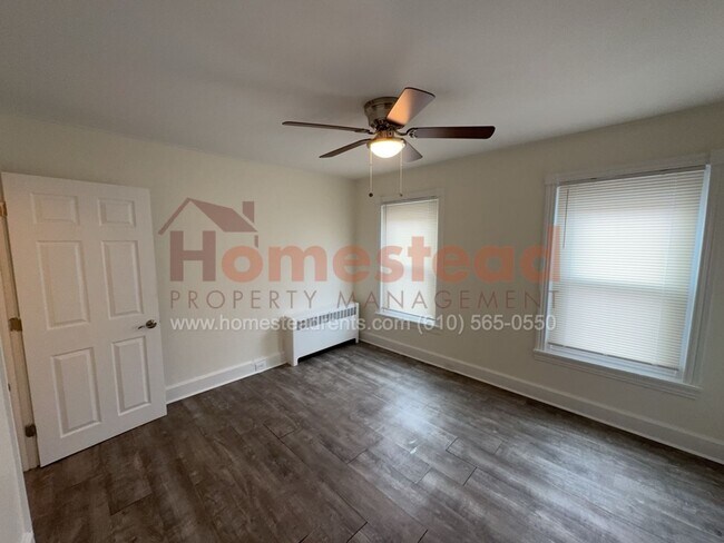
Welcome to this beautiful 2 bedroom home for rent in Norristown! Enter through the first floor to the living room, dining room and kitchen. The kitchen features white shaker cabinets, granite countertop and subway tile backsplash. The landlord has provided a refrigerator, gas stove and microwave. Head upstairs to two large bedrooms and hall bathroom. The basement is unfinished with plenty of room for storage and includes a washer and dryer provided by the landlord. Total equal to three months' Rent required for move-in ($5,100). Tenant responsible for PECO, water, and sewer. Section 8 OK. $50 application fee per adult. APPLY ONLINE AT
437 E Airy St is a house located in Montgomery County and the 19401 ZIP Code. This area is served by the Norristown Area attendance zone.
* Price shown is base rent and may not include non-optional fees and utilities.
Price, availability, fees, and any applicable rent special are subject to change without notice.
* Square footage definitions vary. Displayed square footage is approximate.
Location
Get Directions
The King of Prussia/Norristown region lies approximately 20 miles to the north and west of Philadelphia. The extensive development that this area has gone through since the 1960's has made it a perfect place for professionals seeking worthy employment prospects, without having to resort to living in the big city.
The Valley Forge/King of Prussia area stands as a perfect example of an edge city, a situation where the most prosperity and growth can be seen less in the urban center (in this case, Philadelphia) and more in the areas on its periphery. King of Prussia/Norristown lays claim to the largest shopping mall in the United States, King of Prussia Mall, as well as many of Montgomery County's largest employers. Interstate 276 bisects the area, making it easy to commute for work or leisure.
Learn more about living in Valley Forge/King of Prussia
Education
| Colleges & Universities | Distance | ||
|---|---|---|---|
| Colleges & Universities | Distance | ||
| Drive: | 16 min | 6.6 mi | |
| Drive: | 17 min | 7.0 mi | |
| Drive: | 17 min | 7.2 mi | |
| Drive: | 18 min | 9.2 mi |
437 E Airy St is within 17 minutes or 7.0 miles from Cabrini College. It is also near Montgomery Co. C.C., Central and Eastern University.
Schools


Public Elementary School
Grades K-4
266 Students
Nearby
Public Elementary & Middle School
Grades 5-8
864 Students
Attendance Zone
Public Elementary School
Grades K-4
386 Students
Attendance Zone
Public Elementary School
Grades K
247 Students
Attendance Zone
Public High School
Grades 9-12
2,309 Students
Attendance Zone
Private Elementary & Middle School
Grades 5-9
Nearby
Private Elementary School
Grades PK-3 & 5
69 Students
Nearby
Private Elementary & Middle School
Grades K-8
Nearby
Private High School
Grades 9-12
403 Students
Nearby
School data provided by
 The GreatSchools Rating helps parents compare schools within a state based on a variety of school quality indicators and provides a helpful picture of how effectively each school serves all of its students. Ratings are on a scale of 1 (below average) to 10 (above average) and can include test scores, college readiness, academic progress, advanced courses, equity, discipline and attendance data. We also advise parents to visit schools, consider other information on school performance and programs, and consider family needs as part of the school selection process.
View GreatSchools Rating Methodology
Data provided by GreatSchools.org © 2025. All rights reserved.
View GreatSchools Rating Methodology
Data provided by GreatSchools.org © 2025. All rights reserved.
Transportation options available in Norristown include Norristown Transportation Center (100 Line), located 0.8 mile from 437 E Airy St. 437 E Airy St is near Philadelphia International, located 26.9 miles or 42 minutes away, and Trenton Mercer, located 37.9 miles or 52 minutes away.
| Transit / Subway | Distance | ||
|---|---|---|---|
| Transit / Subway | Distance | ||
|
|
Walk: | 14 min | 0.8 mi |
|
|
Drive: | 5 min | 1.6 mi |
|
|
Drive: | 5 min | 1.7 mi |
|
|
Drive: | 8 min | 3.1 mi |
|
|
Drive: | 10 min | 4.7 mi |
| Commuter Rail | Distance | ||
|---|---|---|---|
| Commuter Rail | Distance | ||
|
|
Walk: | 13 min | 0.7 mi |
| Walk: | 19 min | 1.0 mi | |
| Walk: | 24 min | 1.3 mi | |
|
|
Drive: | 10 min | 4.0 mi |
| Drive: | 10 min | 4.2 mi |
| Airports | Distance | ||
|---|---|---|---|
| Airports | Distance | ||
|
Philadelphia International
|
Drive: | 42 min | 26.9 mi |
|
Trenton Mercer
|
Drive: | 52 min | 37.9 mi |
Time and distance from 437 E Airy St.
| Shopping Centers | Distance | ||
|---|---|---|---|
| Shopping Centers | Distance | ||
| Walk: | 6 min | 0.3 mi | |
| Walk: | 11 min | 0.6 mi | |
| Walk: | 12 min | 0.7 mi |
437 E Airy St has 3 shopping centers within 0.7 mile, which is about a 12-minute walk. The miles and minutes will be for the farthest away property.
| Parks and Recreation | Distance | ||
|---|---|---|---|
| Parks and Recreation | Distance | ||
|
Elmwood Park Zoo
|
Drive: | 6 min | 2.0 mi |
|
Norristown Farm Park
|
Drive: | 10 min | 4.1 mi |
|
McKaig Nature Education Center
|
Drive: | 12 min | 5.2 mi |
|
Henry Botanic Garden
|
Drive: | 15 min | 6.2 mi |
|
Riverbend Environmental Education Center
|
Drive: | 15 min | 6.3 mi |
437 E Airy St has 5 parks within 6.3 miles, including Elmwood Park Zoo, Norristown Farm Park, and McKaig Nature Education Center.
| Hospitals | Distance | ||
|---|---|---|---|
| Hospitals | Distance | ||
| Drive: | 6 min | 1.9 mi | |
| Drive: | 6 min | 2.6 mi | |
| Drive: | 9 min | 2.8 mi |
437 E Airy St has 3 hospitals within 2.8 miles, the nearest is Norristown State Hospital which is 1.9 miles away and a 6 minute drive.
| Military Bases | Distance | ||
|---|---|---|---|
| Military Bases | Distance | ||
| Drive: | 27 min | 16.9 mi |
437 E Airy St is 16.9 miles and a 27 minute drive from Willow Grove Naval Air Station.
You May Also Like
Similar Rentals Nearby


What Are Walk Score®, Transit Score®, and Bike Score® Ratings?
Walk Score® measures the walkability of any address. Transit Score® measures access to public transit. Bike Score® measures the bikeability of any address.
What is a Sound Score Rating?
A Sound Score Rating aggregates noise caused by vehicle traffic, airplane traffic and local sources

437 E Airy St
Norristown, PA 19401