
$2,200
/ Month
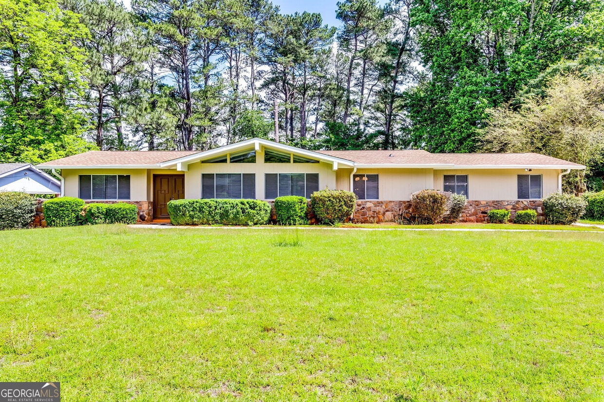
4342 Riverwood Cir
Decatur, GA 30035
Today
|
Edit
Favorites
770-318-2448
-
Bedrooms
3
-
Bathrooms
3
-
Square Feet
1,830 sq ft
-
Available
Available Now
Highlights
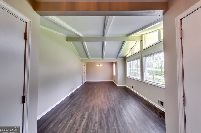
- Ranch Style House
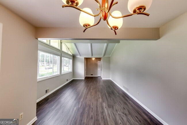
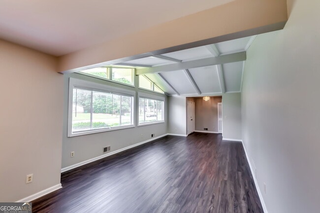
- Wood Flooring
- Patio
- Laundry Room
- Four Sided Brick Exterior Elevation
- Central Heating and Cooling System
4342 Riverwood Cir

Favorites
About This Home
$2,200 deposit,
Available Now
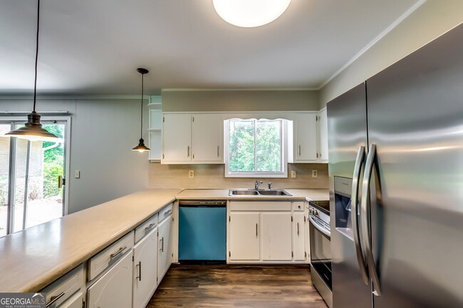
Renovated brick ranch home and ready to be called home! Home has solid surface countertops throughout, with backsplash in kitchen, plumbing and light fixtures have been upgraded throughout. Easy access to I-20, close to downtown Atlanta, the CDC, Emory Hospital, VA. Hospital and Conyers
4342 Riverwood Cir is a house located in DeKalb County and the 30035 ZIP Code. This area is served by the DeKalb County attendance zone.
* Price shown is base rent. Excludes user-selected optional fees and variable or usage-based fees and required charges due at or prior to move-in or at move-out. Price, availability, fees, and any applicable rent special are subject to change without notice.
* Square footage definitions vary. Displayed square footage is approximate.
Home Details
Home Type
Single Family Detached Home
Year Built
Built in 1970
Basement
Crawl Space
Bedrooms and Bathrooms
3 Main Level Bedrooms
3 Full Bathrooms
Flooring
Wood
Carpet
Home Design
Ranch Style House
Four Sided Brick Exterior Elevation
Composition Roof
Interior Spaces
Family Room with Fireplace
1,830 Sq Ft Home
Fireplace Features Masonry
Kitchen
Oven or Range
Dishwasher
Laundry
Laundry Room
Laundry in Hall
Listing and Financial Details
Security Deposit $2,200
12-Month Lease Term
$75 Application Fee
Legal Lot and Block 7 / A
Lot Details
0.36 Acre Lot
No Common Walls
Level Lot
Grass Covered Lot
Outdoor Features
Patio
Parking
Side or Rear Entrance to Parking
4 Car Garage
Parking Accessed On Kitchen Level
Garage Door Opener
Parking Pad
Schools
Canby Lane Elementary School
Mary Mcleod Bethune Middle School
Towers High School
Utilities
Central Heating and Cooling System
High Speed Internet
Gas Water Heater
Cable TV Available
Heating System Uses Natural Gas
Community Details
Overview
No Home Owners Association
Riverwood Subdivision
Pet Policy
No Pets Allowed
Fees and Policies
The fees below are based on community-supplied data and may exclude additional fees and utilities.
- Parking
-
Garage--
Contact
- Listed by Lawrence Sharp | Lawrence Sharp Realtors LLC
- Phone Number
- Contact
-
Source
 Georgia Multiple Listing Service
Copyright © 2025 Georgia Multiple Listing Service. All rights reserved. All information provided by the listing agent / broker is deemed reliable but is not guaranteed and should be independently verified.
Location
Get Directions
Amenities
- Dishwasher
- Range
- Family Room
Southeast DeKalb refers to a sprawling region in the southeastern portion of DeKalb County. Among the many communities in this area are the communities of Clarkston, Stone Mountain, Lithonia, Panthersville, Gresham Park, and Sheffield Woods.
Each community in this region has its own distinct character. Southeast DeKalb offers ample opportunities for outdoor recreation at destinations such as Stone Mountain Park, Panola Mountain State Park, and Arabia Mountain National Heritage Area. Southeast DeKalb sits within easy driving distance of all that Greater Atlanta has to offer, with close proximity to major thoroughfares like I-285, I-20, and U.S. 278.
Learn more about living in Southeast DeKalb
Education
| Colleges & Universities | Distance | ||
|---|---|---|---|
| Colleges & Universities | Distance | ||
| Drive: | 11 min | 6.2 mi | |
| Drive: | 12 min | 6.3 mi | |
| Drive: | 13 min | 7.5 mi | |
| Drive: | 17 min | 9.4 mi |
4342 Riverwood Cir is within 12 minutes or 6.3 miles from Georgia Perim., Clarkston. It is also near Georgia Perim. Coll., Decatur and Agnes Scott College.
Schools


Public Elementary School
Grades PK-5
461 Students
Attendance Zone
Public Middle School
Grades 6-8
718 Students
Attendance Zone
Public High School
Grades 9-12
764 Students
Attendance Zone
Private Elementary, Middle & High School
Grades 3-12
Nearby
Private Elementary, Middle & High School
Grades K-1, 5-7 & 9-11
Nearby
Private Elementary & Middle School
Grades K-8
109 Students
Nearby
Private Elementary School
Grades PK-2
Nearby
School data provided by
 The GreatSchools Rating helps parents compare schools within a state based on a variety of school quality indicators and provides a helpful picture of how effectively each school serves all of its students. Ratings are on a scale of 1 (below average) to 10 (above average) and can include test scores, college readiness, academic progress, advanced courses, equity, discipline and attendance data. We also advise parents to visit schools, consider other information on school performance and programs, and consider family needs as part of the school selection process.
View GreatSchools Rating Methodology
Data provided by GreatSchools.org © 2025. All rights reserved.
View GreatSchools Rating Methodology
Data provided by GreatSchools.org © 2025. All rights reserved.
Transportation options available in Decatur include Indian Creek, located 3.9 miles from 4342 Riverwood Cir. 4342 Riverwood Cir is near Hartsfield - Jackson Atlanta International, located 16.1 miles or 25 minutes away.
| Transit / Subway | Distance | ||
|---|---|---|---|
| Transit / Subway | Distance | ||
|
|
Drive: | 7 min | 3.9 mi |
|
|
Drive: | 9 min | 4.9 mi |
|
|
Drive: | 11 min | 6.5 mi |
|
|
Drive: | 12 min | 7.3 mi |
|
|
Drive: | 14 min | 8.3 mi |
| Commuter Rail | Distance | ||
|---|---|---|---|
| Commuter Rail | Distance | ||
|
|
Drive: | 23 min | 16.5 mi |
| Airports | Distance | ||
|---|---|---|---|
| Airports | Distance | ||
|
Hartsfield - Jackson Atlanta International
|
Drive: | 25 min | 16.1 mi |
Time and distance from 4342 Riverwood Cir.
| Shopping Centers | Distance | ||
|---|---|---|---|
| Shopping Centers | Distance | ||
| Walk: | 10 min | 0.5 mi | |
| Walk: | 11 min | 0.6 mi | |
| Walk: | 12 min | 0.6 mi |
4342 Riverwood Cir has 3 shopping centers within 0.6 mile, which is about a 12-minute walk. The miles and minutes will be for the farthest away property.
| Parks and Recreation | Distance | ||
|---|---|---|---|
| Parks and Recreation | Distance | ||
|
Ferns of the World Garden
|
Drive: | 10 min | 6.0 mi |
|
Glenn Creek Nature Preserve
|
Drive: | 12 min | 7.0 mi |
|
Bradley Observatory
|
Drive: | 11 min | 7.2 mi |
|
Forty Oaks Nature Preserve
|
Drive: | 12 min | 7.5 mi |
|
Wylde Center and Oakhurst Community Garden
|
Drive: | 13 min | 7.8 mi |
4342 Riverwood Cir has 5 parks within 7.8 miles, including Ferns of the World Garden, Forty Oaks Nature Preserve, and Wylde Center and Oakhurst Community Garden.
| Hospitals | Distance | ||
|---|---|---|---|
| Hospitals | Distance | ||
| Drive: | 9 min | 5.6 mi | |
| Drive: | 9 min | 5.7 mi | |
| Drive: | 13 min | 8.0 mi |
4342 Riverwood Cir has 3 hospitals within 8.0 miles, the nearest is Georgia Regional Hospital Atlanta which is 5.6 miles away and a 9 minute drive.
| Military Bases | Distance | ||
|---|---|---|---|
| Military Bases | Distance | ||
| Drive: | 22 min | 13.8 mi | |
| Drive: | 24 min | 16.8 mi |
4342 Riverwood Cir is 13.8 miles from Fort Gillem, and is convenient to other military bases, including Fort McPherson.
You May Also Like
Similar Rentals Nearby
-
-
-
1 / 58

-
-
-
-
-
-
-


What Are Walk Score®, Transit Score®, and Bike Score® Ratings?
Walk Score® measures the walkability of any address. Transit Score® measures access to public transit. Bike Score® measures the bikeability of any address.
What is a Sound Score Rating?
A Sound Score Rating aggregates noise caused by vehicle traffic, airplane traffic and local sources
4342 Riverwood Cir
Decatur, GA 30035