
$1,800
Total Monthly Price
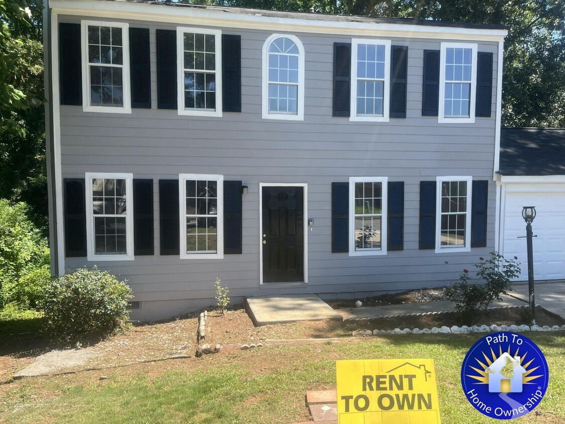
4314 Crestridge Ln
Stone Mountain, GA 30083
Favorites
-
Bedrooms
3
-
Bathrooms
2.5
-
Square Feet
1,500 sq ft
-
Available
Available Now
Highlights
- Playground
- Tennis Court
4314 Crestridge Ln

Favorites
About This Home
12 Month Lease,
$2,000 deposit,
Available Now
Welcome to Crestridge Lane, a comfortable single-family home located in the Stone Mountain area of DeKalb County. This 3-bedroom home offers approximately 1,500 square feet of living space with a practical two-story layout, comfortable room sizes, and strong potential for an owner-occupant, rental property, or long-term investment. Located in the 30083 area, the home offers convenient access to neighborhood schools, shopping, dining, parks, medical care, and major commuter routes. Buyers or renters will appreciate proximity to Allgood Road, North Hairston Road, Memorial Drive, Stone Mountain Village, Stone Mountain Park, US-78, I-285, and I-20. Crestridge Lane offers a strong combination of space, location, and accessibility. Nearby Schools • Allgood Elementary School — approximately 0.2 miles away. • Freedom Middle School — approximately 0.9 miles away. • Clarkston High School — approximately 1.6–1.7 miles away. • DeKalb County School District — school assignments should be verified directly with the district. Nearby Shopping • Memorial Drive retail corridor — major nearby commercial corridor with grocery, pharmacies, gas, restaurants, and everyday services. • Walmart Supercenter — Memorial Drive, Stone Mountain — convenient big-box retail and grocery access. • Kroger — Stone Mountain area — grocery and daily-needs shopping options in the Stone Mountain area. • Stone Mountain Village — local shops, restaurants, small businesses, and community destinations near Stone Mountain Park. • Northlake / Tucker shopping area — additional retail, grocery, restaurants, and service businesses northwest of the property. • Your DeKalb Farmers Market — regional specialty grocery destination in nearby Decatur. Nearby Dining • Stone Mountain Village restaurants — local cafés, restaurants, and neighborhood dining near Main Street and the village area. • The Village Corner German Restaurant & Bakery — long-running Stone Mountain dining option near the village. • Sweet Potato Cafe — popular Stone Mountain restaurant offering Southern-inspired dining. • Metro Cafe Diner — casual dining option in the Stone Mountain area. • Stone Mountain Park dining options — park dining and concessions available depending on season and operating schedule. • Memorial Drive dining corridor — convenient access to casual dining, takeout, fast food, and neighborhood restaurants. Nearby Parks & Recreation • Stone Mountain Park — major regional destination with outdoor recreation, trails, attractions, events, picnic areas, lake access, and family-friendly activities. • Stone Mountain Village / Main Street area — walkable historic area near the park’s west gate with local events and community appeal. • Wade Walker Park — nearby DeKalb County park with athletic fields, tennis courts, netball courts, playground areas, and open recreation space. • Hairston Park area — local outdoor and neighborhood recreation access in the broader Stone Mountain area. • DeKalb County parks system — additional parks, playgrounds, athletic fields, and recreation centers throughout the surrounding area. Nearby Hospitals & Medical Centers • Emory at Stone Mountain — Primary Care — located on Memorial Drive in Stone Mountain. • Northside Primary Care Stone Mountain — primary care access in the Stone Mountain area. • Stone Mountain Immediate Medical Care — local medical clinic access on North Hairston Road. • Emory Hillandale Hospital — regional hospital access east/southeast of Stone Mountain. • Emory Decatur Hospital — major Decatur-area hospital and regional medical center. • Grady Memorial Hospital — major downtown Atlanta hospital and emergency care destination. Nearby Military Bases / Military Facilities • Dobbins Air Reserve Base — active Air Force Reserve installation in Marietta and a major metro Atlanta military facility. • Clay National Guard Center — Georgia National Guard facility in Marietta. • Fort Gillem / Forest Park area — regional military-related facility area south of Atlanta. • Atlanta MEPS / regional military processing facilities — military entrance processing and related facilities serving the broader Atlanta region. • Atlanta VA Medical Center / VA regional facilities — veterans’ healthcare access in the broader Decatur/Atlanta area. Nearby Highways & Major Roads • US-78 / Stone Mountain Freeway — major east-west route connecting Stone Mountain, Tucker, Decatur, and Atlanta. • I-285 — Atlanta’s perimeter highway, providing regional access around the metro area. • I-20 — major east-west interstate south of the property, connecting toward Downtown Atlanta, Decatur, Lithonia, Conyers, and Augusta. • Memorial Drive — major DeKalb County commercial and commuter corridor. • North Hairston Road / South Hairston Road — key local connectors serving Stone Mountain and surrounding DeKalb communities. • Rockbridge Road — local connector with access to schools, parks, neighborhoods, and nearby commercial areas. • Stone Mountain Lithonia Road — regional connector toward Lithonia, Stonecrest, and eastern DeKalb County. • Mountain Industrial Boulevard — nearby commercial and industrial corridor with access toward Tucker, Clarkston, and US-78. Applicants should have: • No evictions or judgments within the past two years • Verifiable household income at least three times the monthly payment amount • Accurate information on the preliminary questionnaire and application Pets: Pets may be allowed with a pet fee and monthly pet rent per pet. Please discuss with us.
4314 Crestridge Ln is a house located in DeKalb County and the 30083 ZIP Code. This area is served by the Dekalb County School District attendance zone.
* Price shown is total price based on community-supplied monthly required fees. Excludes user-selected optional fees and variable or usage-based fees and required charges due at or prior to move-in or at move-out. Price, availability, fees, and any applicable rent special are subject to change without notice.
* Square footage definitions vary. Displayed square footage is approximate.
House Features
- Playground
- Tennis Court
- Walking/Biking Trails
- Picnic Area
- Lake Access
Contact
- Contact
Location
Get Directions
Stone Mountain is a small city in DeKalb County, about 16 miles east of downtown Atlanta, sitting at the western base of one of the largest exposed granite formations in the world. The city proper covers roughly two square miles, but its identity reaches well beyond those borders through Stone Mountain Park, a sprawling state attraction that draws visitors year-round. Locals often refer to the walkable downtown core as Stone Mountain Village, where brick-paved sidewalks pass preserved early 1900s storefronts and the ART Station, a working arts center housed in a restored 1913 trolley barn. The Freedom Bell on Main Street stands as a meaningful landmark tied to Dr. Martin Luther King Jr.'s "I Have a Dream" speech, grounding the city in broader American history.
The housing mix here leans toward single-family homes and smaller apartment communities, giving the area a quieter, close-knit feel compared to Atlanta's denser neighborhoods.
Learn more about living in Stone Mountain
Education
| Colleges & Universities | Distance | ||
|---|---|---|---|
| Colleges & Universities | Distance | ||
| Drive: | 8 min | 3.2 mi | |
| Drive: | 13 min | 6.6 mi | |
| Drive: | 15 min | 7.4 mi | |
| Drive: | 17 min | 8.0 mi |
4314 Crestridge Ln is within 8 minutes or 3.2 miles from Georgia Perim., Clarkston. It is also near Agnes Scott College and Emory University, Clairmont.
Schools


Public Elementary School
Grades PK-5
589 Students
Attendance Zone
Public Middle School
Grades 6-8
1,212 Students
Attendance Zone
Public High School
Grades 9-12
1,384 Students
Attendance Zone
Private Elementary School
Grades PK-5
Nearby
Private Elementary, Middle & High School
Grades K-12
Nearby
School data provided by
 The GreatSchools Rating helps parents compare schools within a state based on a variety of school quality indicators and provides a helpful picture of how effectively each school serves all of its students. Ratings are on a scale of 1 (below average) to 10 (above average) and can include test scores, college readiness, academic progress, advanced courses, equity, discipline and attendance data. We also advise parents to visit schools, consider other information on school performance and programs, and consider family needs as part of the school selection process.
View GreatSchools Rating Methodology
Data provided by GreatSchools.org © 2026. All rights reserved.
View GreatSchools Rating Methodology
Data provided by GreatSchools.org © 2026. All rights reserved.
Transportation options available in Stone Mountain include Indian Creek, located 2.6 miles from 4314 Crestridge Ln. 4314 Crestridge Ln is near Hartsfield - Jackson Atlanta International, located 19.9 miles or 32 minutes away.
| Transit / Subway | Distance | ||
|---|---|---|---|
| Transit / Subway | Distance | ||
|
|
Drive: | 8 min | 2.6 mi |
|
|
Drive: | 8 min | 3.7 mi |
|
|
Drive: | 11 min | 5.6 mi |
|
|
Drive: | 12 min | 6.4 mi |
|
|
Drive: | 13 min | 7.4 mi |
| Commuter Rail | Distance | ||
|---|---|---|---|
| Commuter Rail | Distance | ||
|
|
Drive: | 27 min | 13.1 mi |
| Airports | Distance | ||
|---|---|---|---|
| Airports | Distance | ||
|
Hartsfield - Jackson Atlanta International
|
Drive: | 32 min | 19.9 mi |
Getting Around
 What do Walkability, Transit, Drivability, and Bikeability mean?
Walkability measures the walking distance to day-to-day needs.
Transit measures access to public transportation.
Drivability measures congestion, parking availability, and access to major roads.
Bikeability measures the suitability for cycling.
How It Works
What do Walkability, Transit, Drivability, and Bikeability mean?
Walkability measures the walking distance to day-to-day needs.
Transit measures access to public transportation.
Drivability measures congestion, parking availability, and access to major roads.
Bikeability measures the suitability for cycling.
How It Works
Somewhat Walkable
Walkability
30
/ 100
Minimal Public Transit
Transit
10
/ 100
Very Drivable
Drivability
80
/ 100
Somewhat Bikeable
Bikeability
20
/ 100
Scores provided by
Calm
Soundscore™
82
/ 100
Traffic
CalmAirport
CalmBusinesses
CalmScores provided by
HowLoud What is a Sound Score Rating? A Sound Score Rating aggregates noise caused by vehicle traffic, airplane traffic and local sources. How It WorksTime and distance from 4314 Crestridge Ln.
| Shopping Centers | Distance | ||
|---|---|---|---|
| Shopping Centers | Distance | ||
| Walk: | 17 min | 0.9 mi | |
| Walk: | 17 min | 0.9 mi | |
| Drive: | 3 min | 1.5 mi |
4314 Crestridge Ln has 3 shopping centers within 1.5 miles, which is about a 3-minute drive. The miles and minutes will be for the farthest away property.
| Parks and Recreation | Distance | ||
|---|---|---|---|
| Parks and Recreation | Distance | ||
|
Forty Oaks Nature Preserve
|
Drive: | 9 min | 3.8 mi |
|
Glenn Creek Nature Preserve
|
Drive: | 12 min | 6.1 mi |
|
Bradley Observatory
|
Drive: | 11 min | 6.3 mi |
|
Clyde Shepherd Nature Preserve
|
Drive: | 15 min | 6.5 mi |
|
Stone Mountain State Memorial Park
|
Drive: | 16 min | 6.7 mi |
4314 Crestridge Ln has 5 parks within 6.7 miles, including Forty Oaks Nature Preserve, Stone Mountain State Memorial Park, and Glenn Creek Nature Preserve.
| Hospitals | Distance | ||
|---|---|---|---|
| Hospitals | Distance | ||
| Drive: | 10 min | 5.2 mi | |
| Drive: | 15 min | 7.8 mi | |
| Drive: | 16 min | 7.9 mi |
4314 Crestridge Ln has 3 hospitals within 7.9 miles, the nearest is Emory Decatur Hospital which is 5.2 miles away and a 10 minute drive.
| Military Bases | Distance | ||
|---|---|---|---|
| Military Bases | Distance | ||
| Drive: | 31 min | 17.1 mi | |
| Drive: | 29 min | 17.6 mi | |
| Drive: | 46 min | 30.2 mi |
4314 Crestridge Ln has 3 military bases within 30.2 miles, the nearest is Fort McPherson which is 17.1 miles away and a 31 minute drive.
Amenities
- Picnic Area
- Lake Access
- Playground
- Tennis Court
- Walking/Biking Trails
4314 Crestridge Ln Photos
What Are Walk Score®, Transit Score®, and Bike Score® Ratings?
Walk Score® measures the walkability of any address. Transit Score® measures access to public transit. Bike Score® measures the bikeability of any address.
What is a Sound Score Rating?
A Sound Score Rating aggregates noise caused by vehicle traffic, airplane traffic and local sources.
4314 Crestridge Ln
Stone Mountain, GA 30083