
$5,000
/ Month
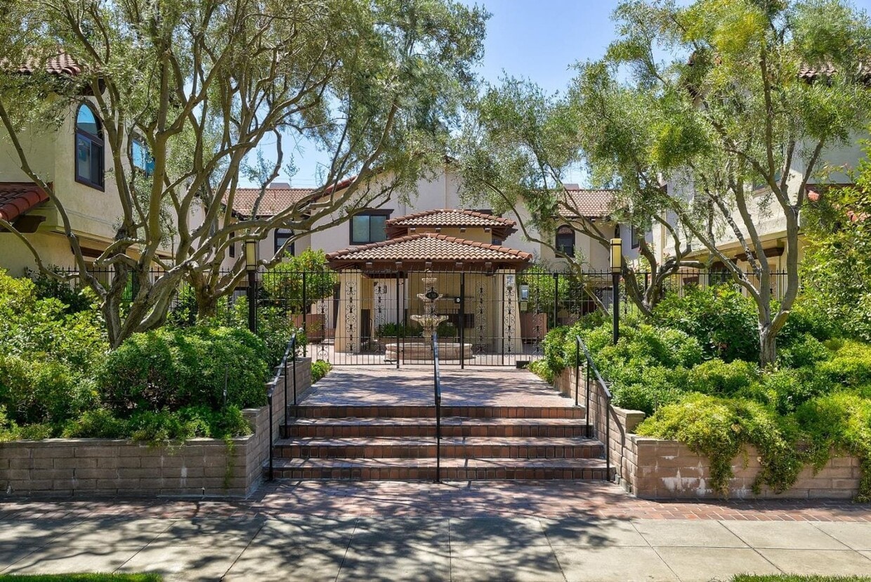
430 Lassen St
Los Altos, CA 94022
2 Weeks Ago
Favorites
430 Lassen St

Favorites
Check Back Soon for Upcoming Availability
| Beds | Baths | Average SF |
|---|---|---|
| 2 Bedrooms 2 Bedrooms 2 Br | 2.5 Baths 2.5 Baths 2.5 Ba | 1,597 SF |
About This Property
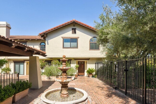
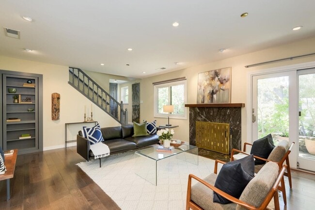
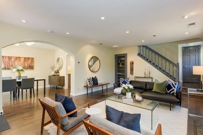
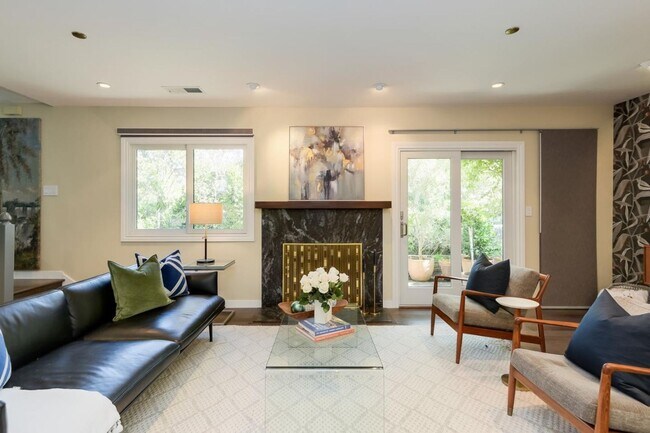
Introducing a meticulously maintained 2 bed, 2.5 bath end unit townhome located near downtown Los Altos, CA. This charming home features a private patio perfect for outdoor entertaining or relaxation. Inside, you'll find beautiful engineered hardwood flooring throughout, as well as new AC and heating systems to keep you comfortable year-round. The new double-pane windows and french doors provide ample natural light, creating a bright and inviting atmosphere. With its convenient location near downtown, this townhome offers easy access to shopping, dining, and entertainment options. Don't miss out on the opportunity to make this lovely townhome your new home sweet home. Other features: -Upgraded kitchen and appliances -Remodeled en suite guest bathroom with radiant floor heating and soaker tub -Double walk-in closets in primary -Private large storage room in garage Parking -2 car garage parking Pets -No pets Laundry -New W/D Included HVAC -Heat and air conditioning Utilities -Water, garbage, and sewer included -Tenant pays other utilities -Tenant to maintain patio landscaping Schools(*Tenants to Verify*) -Covington Elementary -Egan Jr. High -Los Altos High *Unit is staged in photos and to be delivered unfurnished
430 Lassen St is a house located in Santa Clara County and the 94022 ZIP Code. This area is served by the Los Altos Elementary attendance zone.
Location
Get Directions
North Los Altos contains the city’s vibrant commercial centers. The many shops and eateries of Main Street are in the southern portion of North Los Altos, while the diverse restaurants and cafes of San Antonio Road are in the northern stretches near San Antonio Center.
Outside of these commercial areas, North Los Altos is predominantly residential, offering an array of apartments available for rent along tree-lined avenues. Many of the rentals in North Los Altos feature stunning mountain views, as well as close proximity to Mountain View, Foothill College, Stanford University, and Palo Alto. Getting around from North Los Altos is simple with access to El Camino Real, Interstate 280, and San Antonio Station.
Learn more about living in North Los AltosBelow are rent ranges for similar nearby apartments
| Beds | Average Size | Lowest | Typical | Premium |
|---|---|---|---|---|
| Studio Studio Studio | 509 Sq Ft | $2,095 | $4,305 | $12,660 |
| 1 Bed 1 Bed 1 Bed | 757-761 Sq Ft | $2,380 | $3,470 | $5,940 |
| 2 Beds 2 Beds 2 Beds | 1150-1157 Sq Ft | $3,295 | $4,726 | $7,084 |
| 3 Beds 3 Beds 3 Beds | 1468 Sq Ft | $4,441 | $5,479 | $7,300 |
| 4 Beds 4 Beds 4 Beds | 2273 Sq Ft | $5,600 | $10,533 | $15,000 |
Education
| Colleges & Universities | Distance | ||
|---|---|---|---|
| Colleges & Universities | Distance | ||
| Drive: | 5 min | 1.9 mi | |
| Drive: | 8 min | 3.5 mi | |
| Drive: | 12 min | 5.5 mi | |
| Drive: | 13 min | 6.3 mi |
430 Lassen St is within 5 minutes or 1.9 miles from Foothill Coll., Los Altos. It is also near Foothill College, Middlefield and Stanford University.
Schools


Public Elementary School
Grades K-5
367 Students
Nearby
Public Elementary School
Grades K-6
441 Students
Attendance Zone
Public Middle School
Grades 7-8
497 Students
Attendance Zone
Public High School
Grades 9-12
2,141 Students
Attendance Zone
Private Elementary & Middle School
Grades 1-8
250 Students
Nearby
Private Elementary & Middle School
Grades K-7
Nearby
Private Elementary School
Grades K-6
75 Students
Nearby
Private High School
Grades 9-12
1,776 Students
Nearby
School data provided by
 The GreatSchools Rating helps parents compare schools within a state based on a variety of school quality indicators and provides a helpful picture of how effectively each school serves all of its students. Ratings are on a scale of 1 (below average) to 10 (above average) and can include test scores, college readiness, academic progress, advanced courses, equity, discipline and attendance data. We also advise parents to visit schools, consider other information on school performance and programs, and consider family needs as part of the school selection process.
View GreatSchools Rating Methodology
Data provided by GreatSchools.org © 2025. All rights reserved.
View GreatSchools Rating Methodology
Data provided by GreatSchools.org © 2025. All rights reserved.
Transportation options available in Los Altos include Whisman Station, located 4.2 miles from 430 Lassen St. 430 Lassen St is near Norman Y Mineta San Jose International, located 12.0 miles or 21 minutes away, and San Francisco International, located 26.2 miles or 37 minutes away.
| Transit / Subway | Distance | ||
|---|---|---|---|
| Transit / Subway | Distance | ||
|
|
Drive: | 11 min | 4.2 mi |
| Drive: | 8 min | 4.4 mi | |
|
|
Drive: | 8 min | 4.4 mi |
|
|
Drive: | 11 min | 4.5 mi |
| Drive: | 12 min | 6.3 mi |
| Commuter Rail | Distance | ||
|---|---|---|---|
| Commuter Rail | Distance | ||
| Drive: | 5 min | 2.5 mi | |
| Drive: | 9 min | 3.1 mi | |
| Drive: | 10 min | 3.3 mi | |
| Drive: | 11 min | 4.7 mi | |
| Drive: | 11 min | 4.9 mi |
| Airports | Distance | ||
|---|---|---|---|
| Airports | Distance | ||
|
Norman Y Mineta San Jose International
|
Drive: | 21 min | 12.0 mi |
|
San Francisco International
|
Drive: | 37 min | 26.2 mi |
Time and distance from 430 Lassen St.
| Shopping Centers | Distance | ||
|---|---|---|---|
| Shopping Centers | Distance | ||
| Drive: | 5 min | 1.5 mi | |
| Drive: | 4 min | 1.8 mi | |
| Drive: | 5 min | 1.8 mi |
430 Lassen St has 3 shopping centers within 1.8 miles, which is about a 5-minute drive. The miles and minutes will be for the farthest away property.
| Parks and Recreation | Distance | ||
|---|---|---|---|
| Parks and Recreation | Distance | ||
|
Redwood Grove
|
Drive: | 4 min | 1.4 mi |
|
Foothill College Observatory
|
Drive: | 6 min | 2.1 mi |
|
Terman Park
|
Drive: | 6 min | 2.9 mi |
|
Esther Clark Nature Preserve
|
Drive: | 6 min | 2.9 mi |
|
Byrne Preserve
|
Drive: | 8 min | 3.4 mi |
430 Lassen St has 5 parks within 3.4 miles, including Redwood Grove, Foothill College Observatory, and Esther Clark Nature Preserve.
| Hospitals | Distance | ||
|---|---|---|---|
| Hospitals | Distance | ||
| Drive: | 6 min | 2.4 mi | |
| Drive: | 13 min | 6.4 mi | |
| Drive: | 14 min | 6.6 mi |
430 Lassen St has 3 hospitals within 6.6 miles, the nearest is El Camino Hospital which is 2.4 miles away and a 6 minute drive.
| Military Bases | Distance | ||
|---|---|---|---|
| Military Bases | Distance | ||
| Drive: | 15 min | 6.7 mi |
430 Lassen St is 6.7 miles and a 15 minute drive from Ames Research Center.
You May Also Like
Similar Rentals Nearby


What Are Walk Score®, Transit Score®, and Bike Score® Ratings?
Walk Score® measures the walkability of any address. Transit Score® measures access to public transit. Bike Score® measures the bikeability of any address.
What is a Sound Score Rating?
A Sound Score Rating aggregates noise caused by vehicle traffic, airplane traffic and local sources

430 Lassen St
Los Altos, CA 94022