

$6,995
/ Month
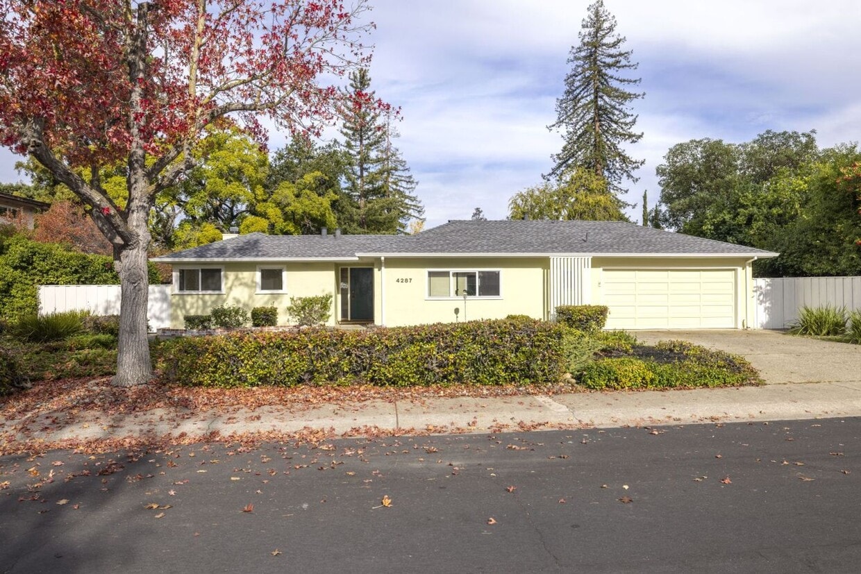
4287 Pomona Ave
Palo Alto, CA 94306
Today
|
Edit
Favorites
650-331-1515
-
Bedrooms
3
-
Bathrooms
3
-
Square Feet
1,886 sq ft
-
Available
Available Now
4287 Pomona Ave

Favorites
About This Home
$7,000 deposit,
Available Now
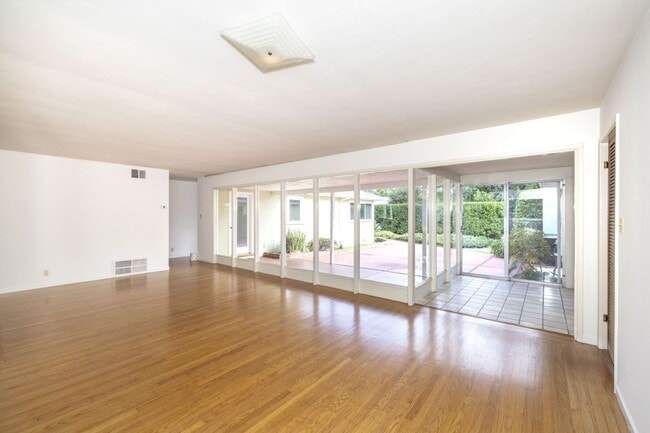
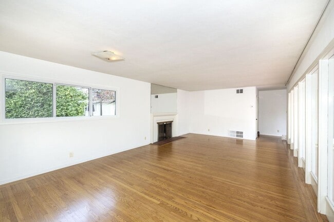
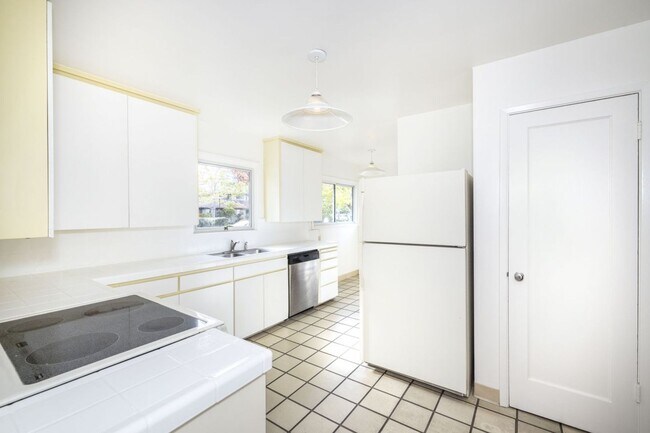
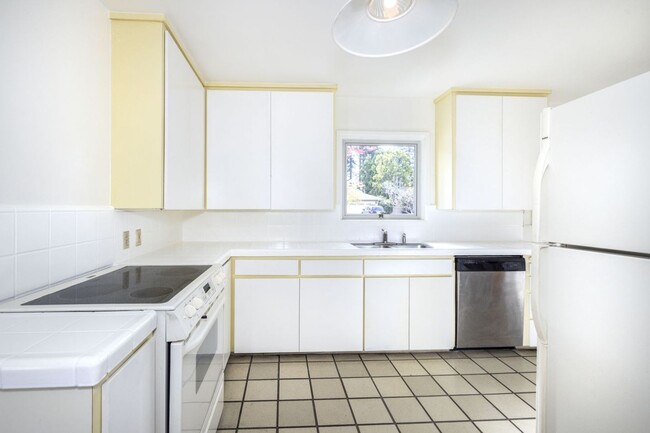
This is a spacious 3 bed, 3 bath home with flexible lease terms- minimum 6 months preferred, with month to month after Ideal for those remodeling, in transition, or exploring the area! Large family room with wall of windows letting in tons of natural light Eat-in kitchen with plenty of countertop and cabinet space Hardwood floors throughout Living room overlooks private, fully fenced yard (twice per month gardening included) Oversized two car garage with room for storage A short stroll to Briones ES, Fletcher MS, and Gunn High (tenant to verify school availability) Conveniently close to shopping, VA & Stanford hospital, parks, major employers, CalTrain, 280, and more! Contact Katie for showings Midtown Management, Inc. License #02186084
Unique Features
- flexible lease
- drought tolerant landscaping
- hard flooring
- attached two car garage
4287 Pomona Ave is a house located in Santa Clara County and the 94306 ZIP Code. This area is served by the Palo Alto Unified attendance zone.
* Price shown is base rent. Excludes user-selected optional fees and variable or usage-based fees and required charges due at or prior to move-in or at move-out. Price, availability, fees, and any applicable rent special are subject to change without notice.
* Square footage definitions vary. Displayed square footage is approximate.
Fees and Policies
The fees below are based on community-supplied data and may exclude additional fees and utilities.
-
One-Time Basics
-
Due at Move-In
-
Security Deposit - RefundableCharged per unit.$7,000
-
-
Due at Move-In
Property Fee Disclaimer: Based on community-supplied data and independent market research. Subject to change without notice. May exclude fees for mandatory or optional services and usage-based utilities.
Contact
- Listed by Midtown Management Inc. | Midtown Management Inc.
- Phone Number
- Contact
Location
Get Directions
Amenities
- flexible lease
- drought tolerant landscaping
- hard flooring
- attached two car garage
North Los Altos contains the city’s vibrant commercial centers. The many shops and eateries of Main Street are in the southern portion of North Los Altos, while the diverse restaurants and cafes of San Antonio Road are in the northern stretches near San Antonio Center.
Outside of these commercial areas, North Los Altos is predominantly residential, offering an array of apartments available for rent along tree-lined avenues. Many of the rentals in North Los Altos feature stunning mountain views, as well as close proximity to Mountain View, Foothill College, Stanford University, and Palo Alto. Getting around from North Los Altos is simple with access to El Camino Real, Interstate 280, and San Antonio Station.
Learn more about living in North Los Altos
Education
| Colleges & Universities | Distance | ||
|---|---|---|---|
| Colleges & Universities | Distance | ||
| Drive: | 7 min | 2.1 mi | |
| Drive: | 10 min | 4.1 mi | |
| Drive: | 10 min | 4.5 mi | |
| Drive: | 15 min | 6.0 mi |
4287 Pomona Ave is within 7 minutes or 2.1 miles from Foothill College, Middlefield. It is also near Stanford University and Foothill Coll., Los Altos.
Schools


Public Elementary School
Grades K-5
367 Students
Nearby
Public Elementary School
Grades K-5
258 Students
Attendance Zone
Public Middle School
Grades 6-8
515 Students
Attendance Zone
Public High School
Grades 9-12
1,787 Students
Attendance Zone
Private Elementary School
Grades PK-5
Nearby
Private Elementary, Middle & High School
Grades K-12
Nearby
Private Elementary & Middle School
Grades K-8
268 Students
Nearby
School data provided by
 The GreatSchools Rating helps parents compare schools within a state based on a variety of school quality indicators and provides a helpful picture of how effectively each school serves all of its students. Ratings are on a scale of 1 (below average) to 10 (above average) and can include test scores, college readiness, academic progress, advanced courses, equity, discipline and attendance data. We also advise parents to visit schools, consider other information on school performance and programs, and consider family needs as part of the school selection process.
View GreatSchools Rating Methodology
Data provided by GreatSchools.org © 2026. All rights reserved.
View GreatSchools Rating Methodology
Data provided by GreatSchools.org © 2026. All rights reserved.
Transportation options available in Palo Alto include Mountain View Station, located 3.7 miles from 4287 Pomona Ave. 4287 Pomona Ave is near Norman Y Mineta San Jose International, located 13.0 miles or 21 minutes away, and San Francisco International, located 24.8 miles or 36 minutes away.
| Transit / Subway | Distance | ||
|---|---|---|---|
| Transit / Subway | Distance | ||
| Drive: | 8 min | 3.7 mi | |
|
|
Drive: | 8 min | 3.7 mi |
|
|
Drive: | 11 min | 4.9 mi |
| Drive: | 11 min | 5.4 mi | |
|
|
Drive: | 12 min | 5.6 mi |
| Commuter Rail | Distance | ||
|---|---|---|---|
| Commuter Rail | Distance | ||
| Drive: | 5 min | 2.1 mi | |
| Drive: | 7 min | 2.6 mi | |
| Drive: | 7 min | 2.8 mi | |
| Drive: | 10 min | 4.1 mi | |
| Drive: | 11 min | 4.3 mi |
| Airports | Distance | ||
|---|---|---|---|
| Airports | Distance | ||
|
Norman Y Mineta San Jose International
|
Drive: | 21 min | 13.0 mi |
|
San Francisco International
|
Drive: | 36 min | 24.8 mi |
Time and distance from 4287 Pomona Ave.
| Shopping Centers | Distance | ||
|---|---|---|---|
| Shopping Centers | Distance | ||
| Drive: | 3 min | 1.2 mi | |
| Drive: | 4 min | 1.6 mi | |
| Drive: | 4 min | 1.8 mi |
4287 Pomona Ave has 3 shopping centers within 1.8 miles, which is about a 4-minute drive. The miles and minutes will be for the farthest away property.
| Parks and Recreation | Distance | ||
|---|---|---|---|
| Parks and Recreation | Distance | ||
|
Terman Park
|
Walk: | 7 min | 0.4 mi |
|
Esther Clark Nature Preserve
|
Drive: | 4 min | 1.4 mi |
|
Bol Park
|
Drive: | 5 min | 1.6 mi |
|
J. Pearce Mitchell Park
|
Drive: | 6 min | 2.0 mi |
|
Redwood Grove
|
Drive: | 6 min | 2.8 mi |
4287 Pomona Ave has 5 parks within 2.8 miles, including Terman Park, Bol Park, and Esther Clark Nature Preserve.
| Hospitals | Distance | ||
|---|---|---|---|
| Hospitals | Distance | ||
| Drive: | 11 min | 4.5 mi | |
| Drive: | 11 min | 4.8 mi | |
| Drive: | 11 min | 5.0 mi |
4287 Pomona Ave has 3 hospitals within 5.0 miles, the nearest is Lucile Salter Packard Children's Hospital at Stanford which is 4.5 miles away and a 11 minute drive.
| Military Bases | Distance | ||
|---|---|---|---|
| Military Bases | Distance | ||
| Drive: | 14 min | 5.9 mi |
4287 Pomona Ave is 5.9 miles and a 14 minute drive from Ames Research Center.
You May Also Like
Similar Rentals Nearby


What Are Walk Score®, Transit Score®, and Bike Score® Ratings?
Walk Score® measures the walkability of any address. Transit Score® measures access to public transit. Bike Score® measures the bikeability of any address.
What is a Sound Score Rating?
A Sound Score Rating aggregates noise caused by vehicle traffic, airplane traffic and local sources
4287 Pomona Ave
Palo Alto, CA 94306