
$3,500
Total Monthly Price
4276 Wilkie Way Unit G
Palo Alto, CA 94306
2 Weeks Ago
|
Edit
Favorites
-
Bedrooms
2
-
Bathrooms
1
-
Square Feet
800 sq ft
Highlights
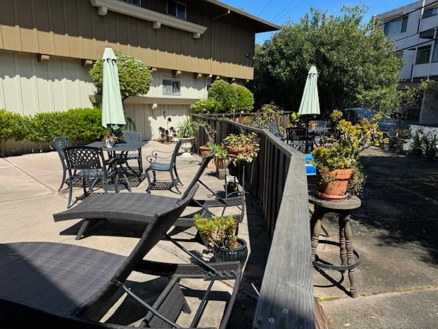
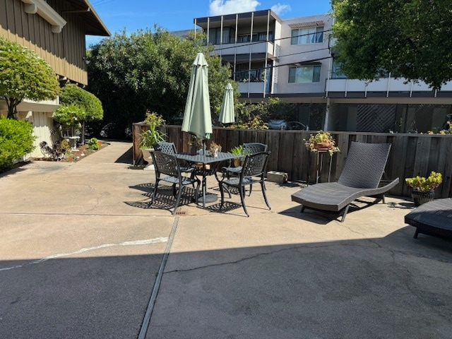
- Pool
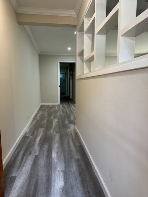
- Hardwood Floors
- Yard
- Smoke Free
- Security System
4276 Wilkie Way Unit G

Favorites
About This Home
12 Month Lease,
$1,000 deposit
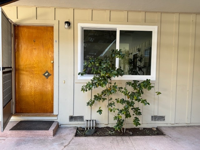
2 bedroom 1 bath apartment with huge backyard in a quite community in Palo Alto. Hardwood floors, plenty of closet space in the hallway and in bedroom. Unit faces a private courtyard with direct entrance. Covered parking spaces (carport) with storage units. Laundry on site. Heated Pool with a BBQ area for entertaining. Immaculate landscaping with lemon and orange tress. Complex is monitored 24/7 with Security cameras. Water and garbage included. Resident managers on site. Located at the end of a beautiful tree lined street right next to bike bridge connecting Palo Alto to Mountain View. Within walking distance to Caltrain Station, Whole Foods, Trader Joe's, Safeway, Walmart, Target, CVS, Walgreens
4276 Wilkie Way is an apartment community located in Santa Clara County and the 94306 ZIP Code.
* Price shown is total price based on community-supplied monthly required fees. Excludes user-selected optional fees and variable or usage-based fees and required charges due at or prior to move-in or at move-out. Price, availability, fees, and any applicable rent special are subject to change without notice.
* Square footage definitions vary. Displayed square footage is approximate.
Apartment Features
Dishwasher
Hardwood Floors
Granite Countertops
Refrigerator
- Heating
- Ceiling Fans
- Smoke Free
- Cable Ready
- Security System
- Storage Space
- Dishwasher
- Disposal
- Granite Countertops
- Stainless Steel Appliances
- Oven
- Range
- Refrigerator
- Hardwood Floors
- Laundry Facilities
- Video Patrol
- Pool
- Courtyard
- Grill
- Yard
Fees and Policies
The fees listed below are community-provided and may exclude utilities or add-ons. All payments are made directly to the property and are non-refundable unless otherwise specified.
- Parking
-
Covered--
Details
Utilities Included
-
Water
-
Trash Removal
-
Sewer
Property Information
-
32 units
Contact
Location
Get Directions
Living in Palo Alto places you in Silicon Valley, where historic neighborhoods complement the city's technological presence. Tree-lined streets wind through the community, which is anchored by Stanford University. University Avenue features local boutiques and restaurants housed in preserved historic buildings, while the Stanford Shopping Center offers high-end retail destinations. The city maintains 36 parks and preserves, including the Baylands Nature Preserve and Foothills Park, where residents enjoy hiking trails and outdoor activities. Palo Alto's infrastructure supports alternative transportation, with dedicated bike lanes throughout the city.
The rental market in Palo Alto reflects the area's popularity, with current average rents ranging from $2,634 for studios to $6,139 for four-bedroom homes. Recent trends show steady growth, with rent increases varying from 1.8% to 17% across different unit sizes over the past year.
Learn more about living in Palo Alto
Education
| Colleges & Universities | Distance | ||
|---|---|---|---|
| Colleges & Universities | Distance | ||
| Drive: | 6 min | 1.6 mi | |
| Drive: | 10 min | 3.6 mi | |
| Drive: | 12 min | 4.8 mi | |
| Drive: | 15 min | 5.8 mi |
4276 Wilkie Way Unit G is within 6 minutes or 1.6 miles from Foothill College, Middlefield. It is also near Stanford University and Foothill Coll., Los Altos.
Transportation options available in Palo Alto include Mountain View Station, located 3.1 miles from 4276 Wilkie Way Unit G. 4276 Wilkie Way Unit G is near Norman Y Mineta San Jose International, located 12.5 miles or 20 minutes away, and San Francisco International, located 24.2 miles or 34 minutes away.
| Transit / Subway | Distance | ||
|---|---|---|---|
| Transit / Subway | Distance | ||
| Drive: | 6 min | 3.1 mi | |
|
|
Drive: | 9 min | 4.4 mi |
| Drive: | 10 min | 4.9 mi | |
|
|
Drive: | 11 min | 5.1 mi |
| Drive: | 12 min | 5.8 mi |
| Commuter Rail | Distance | ||
|---|---|---|---|
| Commuter Rail | Distance | ||
| Drive: | 5 min | 1.7 mi | |
| Drive: | 7 min | 2.5 mi | |
| Drive: | 9 min | 3.6 mi | |
| Drive: | 10 min | 3.9 mi | |
| Drive: | 12 min | 5.0 mi |
| Airports | Distance | ||
|---|---|---|---|
| Airports | Distance | ||
|
Norman Y Mineta San Jose International
|
Drive: | 20 min | 12.5 mi |
|
San Francisco International
|
Drive: | 34 min | 24.2 mi |
Getting Around
 What do Walkability, Transit, Drivability, and Bikeability mean?
Walkability measures the walking distance to day-to-day needs.
Transit measures access to public transportation.
Drivability measures congestion, parking availability, and access to major roads.
Bikeability measures the suitability for cycling.
How It Works
What do Walkability, Transit, Drivability, and Bikeability mean?
Walkability measures the walking distance to day-to-day needs.
Transit measures access to public transportation.
Drivability measures congestion, parking availability, and access to major roads.
Bikeability measures the suitability for cycling.
How It Works
Fairly Walkable
Walkability
50
/ 100
Limited Public Transit
Transit
30
/ 100
Very Drivable
Drivability
80
/ 100
Moderately Bikeable
Bikeability
70
/ 100
Scores provided by
-
Soundscore™
-
/ 100
Traffic
-Airport
-Businesses
-Scores provided by
HowLoud What is a Sound Score Rating? A Sound Score Rating aggregates noise caused by vehicle traffic, airplane traffic and local sources. How It WorksTime and distance from 4276 Wilkie Way Unit G.
| Shopping Centers | Distance | ||
|---|---|---|---|
| Shopping Centers | Distance | ||
| Walk: | 17 min | 0.9 mi | |
| Drive: | 5 min | 1.7 mi | |
| Drive: | 5 min | 1.8 mi |
4276 Wilkie Way Unit G has 3 shopping centers within 1.8 miles, which is about a 5-minute drive. The miles and minutes will be for the farthest away property.
| Parks and Recreation | Distance | ||
|---|---|---|---|
| Parks and Recreation | Distance | ||
|
Terman Park
|
Drive: | 4 min | 1.2 mi |
|
J. Pearce Mitchell Park
|
Drive: | 5 min | 1.6 mi |
|
Bol Park
|
Drive: | 6 min | 2.1 mi |
|
Esther Clark Nature Preserve
|
Drive: | 7 min | 2.2 mi |
|
Redwood Grove
|
Drive: | 9 min | 3.6 mi |
4276 Wilkie Way Unit G has 5 parks within 3.6 miles, including Terman Park, J. Pearce Mitchell Park, and Bol Park.
| Hospitals | Distance | ||
|---|---|---|---|
| Hospitals | Distance | ||
| Drive: | 11 min | 4.3 mi | |
| Drive: | 11 min | 4.7 mi | |
| Drive: | 13 min | 4.8 mi |
4276 Wilkie Way Unit G has 3 hospitals within 4.8 miles, the nearest is Lucile Salter Packard Children's Hospital at Stanford which is 4.3 miles away and a 11 minute drive.
| Military Bases | Distance | ||
|---|---|---|---|
| Military Bases | Distance | ||
| Drive: | 13 min | 5.3 mi |
4276 Wilkie Way Unit G is 5.3 miles and a 13 minute drive from Ames Research Center.
Amenities
- Heating
- Ceiling Fans
- Smoke Free
- Cable Ready
- Security System
- Storage Space
- Dishwasher
- Disposal
- Granite Countertops
- Stainless Steel Appliances
- Oven
- Range
- Refrigerator
- Hardwood Floors
- Laundry Facilities
- Video Patrol
- Courtyard
- Grill
- Yard
- Pool
4276 Wilkie Way Unit G Photos
What Are Walk Score®, Transit Score®, and Bike Score® Ratings?
Walk Score® measures the walkability of any address. Transit Score® measures access to public transit. Bike Score® measures the bikeability of any address.
What is a Sound Score Rating?
A Sound Score Rating aggregates noise caused by vehicle traffic, airplane traffic and local sources.

4276 Wilkie Way
Palo Alto, CA 94306