
$2,750 / Month
4276 Wilkie Way Unit D
Palo Alto, CA 94306
2 Weeks Ago
Favorites
4276 Wilkie Way Unit D

Favorites
Check Back Soon for Upcoming Availability
| Beds | Baths | Average SF |
|---|---|---|
| 2 Bedrooms 2 Bedrooms 2 Br | 1 Bath 1 Bath 1 Ba | 750 SF |
Fees and Policies
The fees below are based on community-supplied data and may exclude additional fees and utilities.
- Cats Allowed
-
Fees not specified
-
Weight limit--
-
Pet Limit--
- Parking
-
Covered--
Details
Utilities Included
-
Water
-
Trash Removal
-
Sewer
Property Information
-
32 units
About This Property
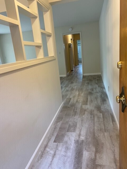
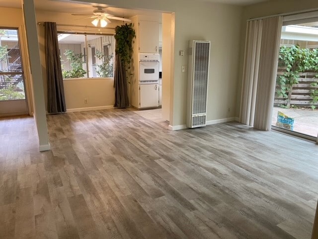
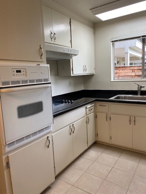
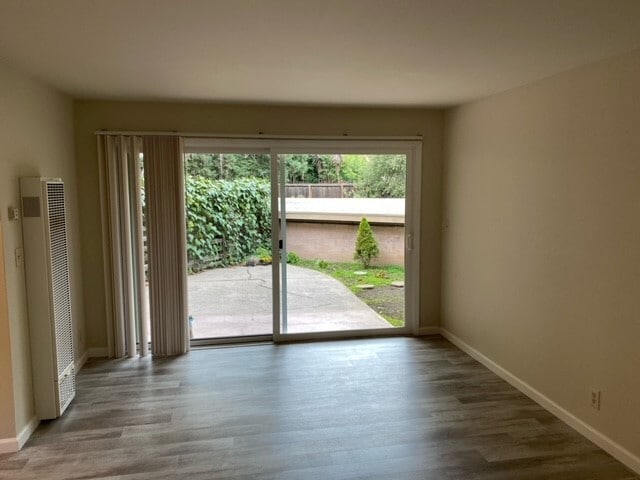
2 bedroom 1 bath apartment with huge backyard in a quite community in Palo Alto. Hardwood floors, plenty of closet space in the hallway and in bedroom. Unit faces a private courtyard with direct entrance. Covered parking spaces (carport) with storage units. Laundry on site. Heated Pool with a BBQ area for entertaining. Immaculate landscaping with lemon and orange tress. Complex is monitored 24/7 with Security cameras. Water and garbage included. Resident managers on site. Located at the end of a beautiful tree lined street right next to bike bridge connecting Palo Alto to Mountain View. Within walking distance to Caltrain Station, Whole Foods, Trader Joe's, Safeway, Walmart, Target, CVS, Walgreens
4276 Wilkie Way is an apartment community located in Santa Clara County and the 94306 ZIP Code.
Apartment Features
Hardwood Floors
Granite Countertops
Refrigerator
Disposal
- Heating
- Smoke Free
- Cable Ready
- Storage Space
- Disposal
- Granite Countertops
- Oven
- Refrigerator
- Hardwood Floors
- Laundry Facilities
- Pool
- Courtyard
- Yard
Location
Get Directions
Palo Alto is known as the birthplace of Silicon Valley and that unique heritage is proudly on display, with the Computer History Museum just down the street from Google’s world headquarters and countless other tech companies all over town. The restaurant scene rivals that of nearby San Francisco, with many small, independent eateries serving up some of the best food in the Bay Area.
With close proximity to the country’s tech center, it’s no surprise that Palo Alto apartments come with some of the most incredible amenities around. Residents also have access to dozens of options for outdoor recreation, including the gorgeous hiking and biking trails through the surrounding nature preserves, several golf courses, and easy access to San Francisco Bay. Bicycling is a popular mode of transportation around Palo Alto, with many bike-friendly routes around the city.
Palo Alto is famous as the home of Stanford University, and the campus is one of the most dominant landmarks in the area.
Learn more about living in Palo AltoBelow are rent ranges for similar nearby apartments
Amenities
- Heating
- Smoke Free
- Cable Ready
- Storage Space
- Disposal
- Granite Countertops
- Oven
- Refrigerator
- Hardwood Floors
- Laundry Facilities
- Courtyard
- Yard
- Pool
Expenses
Utilities Included
Water, Trash Removal, Sewer
Included
Education
| Colleges & Universities | Distance | ||
|---|---|---|---|
| Colleges & Universities | Distance | ||
| Drive: | 6 min | 1.6 mi | |
| Drive: | 10 min | 3.6 mi | |
| Drive: | 12 min | 4.8 mi | |
| Drive: | 15 min | 5.8 mi |
4276 Wilkie Way Unit D is within 6 minutes or 1.6 miles from Foothill College, Middlefield. It is also near Stanford University and Foothill Coll., Los Altos.
Transportation options available in Palo Alto include Mountain View Station, located 3.1 miles from 4276 Wilkie Way Unit D. 4276 Wilkie Way Unit D is near Norman Y Mineta San Jose International, located 12.5 miles or 20 minutes away, and San Francisco International, located 24.2 miles or 34 minutes away.
| Transit / Subway | Distance | ||
|---|---|---|---|
| Transit / Subway | Distance | ||
| Drive: | 6 min | 3.1 mi | |
|
|
Drive: | 6 min | 3.2 mi |
|
|
Drive: | 9 min | 4.4 mi |
| Drive: | 10 min | 4.9 mi | |
|
|
Drive: | 11 min | 5.1 mi |
| Commuter Rail | Distance | ||
|---|---|---|---|
| Commuter Rail | Distance | ||
| Drive: | 4 min | 1.7 mi | |
| Drive: | 6 min | 2.4 mi | |
| Drive: | 7 min | 2.5 mi | |
| Drive: | 9 min | 3.6 mi | |
| Drive: | 10 min | 3.8 mi |
| Airports | Distance | ||
|---|---|---|---|
| Airports | Distance | ||
|
Norman Y Mineta San Jose International
|
Drive: | 20 min | 12.5 mi |
|
San Francisco International
|
Drive: | 34 min | 24.2 mi |
Time and distance from 4276 Wilkie Way Unit D.
| Shopping Centers | Distance | ||
|---|---|---|---|
| Shopping Centers | Distance | ||
| Walk: | 8 min | 0.4 mi | |
| Drive: | 5 min | 1.7 mi | |
| Drive: | 5 min | 1.8 mi |
4276 Wilkie Way Unit D has 3 shopping centers within 1.8 miles, which is about a 5-minute walk. The miles and minutes will be for the farthest away property.
| Parks and Recreation | Distance | ||
|---|---|---|---|
| Parks and Recreation | Distance | ||
|
Terman Park
|
Drive: | 4 min | 1.2 mi |
|
J. Pearce Mitchell Park
|
Drive: | 5 min | 1.6 mi |
|
Bol Park
|
Drive: | 6 min | 2.1 mi |
|
Esther Clark Nature Preserve
|
Drive: | 7 min | 2.2 mi |
|
Redwood Grove
|
Drive: | 9 min | 3.6 mi |
4276 Wilkie Way Unit D has 5 parks within 3.6 miles, including Terman Park, J. Pearce Mitchell Park, and Bol Park.
| Hospitals | Distance | ||
|---|---|---|---|
| Hospitals | Distance | ||
| Drive: | 11 min | 4.3 mi | |
| Drive: | 11 min | 4.7 mi | |
| Drive: | 13 min | 4.8 mi |
4276 Wilkie Way Unit D has 3 hospitals within 4.8 miles, the nearest is Lucile Salter Packard Children's Hospital at Stanford which is 4.3 miles away and a 11 minute drive.
| Military Bases | Distance | ||
|---|---|---|---|
| Military Bases | Distance | ||
| Drive: | 13 min | 5.3 mi |
4276 Wilkie Way Unit D is 5.3 miles and a 13 minute drive from Ames Research Center.
You May Also Like
Similar Rentals Nearby


What Are Walk Score®, Transit Score®, and Bike Score® Ratings?
Walk Score® measures the walkability of any address. Transit Score® measures access to public transit. Bike Score® measures the bikeability of any address.
What is a Sound Score Rating?
A Sound Score Rating aggregates noise caused by vehicle traffic, airplane traffic and local sources

4276 Wilkie Way
Palo Alto, CA 94306