
$5,495
Total Monthly Price
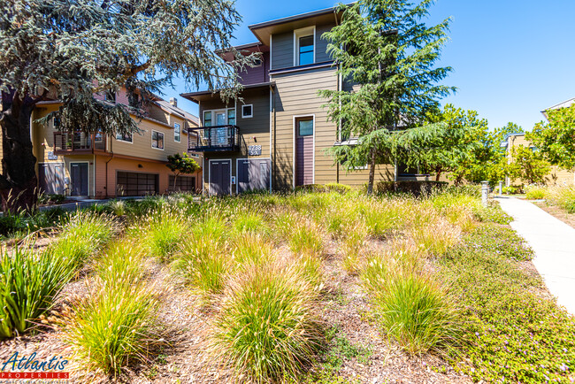
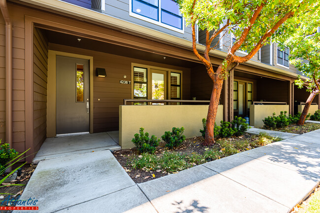
4238 Rickeys Way Unit T
Palo Alto, CA 94306
2 Weeks Ago
|
Edit
Favorites
4238 Rickeys Way

Favorites
Check Back Soon for Upcoming Availability
| Beds | Baths | Average SF |
|---|---|---|
| 3 Bedrooms 3 Bedrooms 3 Br | 3 Baths 3 Baths 3 Ba | 1,913 SF |
Fees and Policies
The fees listed below are community-provided and may exclude utilities or add-ons. All payments are made directly to the property and are non-refundable unless otherwise specified.
- Parking
-
Garage--
About This Property
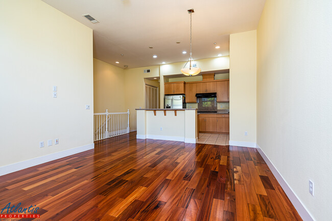
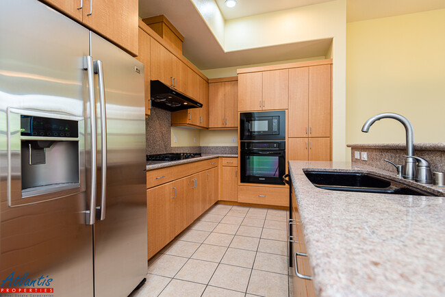
- Arbor Real - Fabulous 3 Bedroom, 3 Bath Townhouse - Home Features Include Hardwood Flooring, New Carpet, High Ceilings Double-Pane Windows, New 2" Blinds (Not Pictured), Recessed Lighting & Ceiling Fans - Spacious Living Room/Dining Area - Kitchen Features Granite Counters, Stylish Cabinetry, Refrigerator, Gas Cook-Top, Built-In Oven, Dishwasher, Built-In Microwave & Garbage Disposal - First & Third Floor Bedroom En Suites - Central Heat & Central Air Conditioning - In Unit Washer/Dryer - Attached Two-Car Garage w/ Storage & Guest Parking - Community Includes Swimming Pool, Children's Play Area & Clubhouse - Juana Briones Elementary School, Ellen Fletcher Middle School, Henry M. Gunn High School (Tenant To Verify) - Easy Access To El Camino Real, Shops, Restaurants & Major Silicon Valley Employers - Tenant Pays Utilities - No Smoking - No Pets - Minimum One Year Lease - Tenant Must Have Renter's Insurance Rental Requirements: Household monthly gross income of at least three times the rent, good standing credit history & rental references. Please note, we can hold a property for a maximum of two weeks from the date of approval. DRE # 01498174
4238 Rickeys Way is a townhome located in Santa Clara County and the 94306 ZIP Code.
Townhome Features
Washer/Dryer
Air Conditioning
Dishwasher
Hardwood Floors
- Washer/Dryer
- Air Conditioning
- Heating
- Ceiling Fans
- Smoke Free
- Tub/Shower
- Dishwasher
- Disposal
- Granite Countertops
- Kitchen
- Microwave
- Oven
- Range
- Refrigerator
- Hardwood Floors
- Carpet
- Walk-In Closets
- Double Pane Windows
- Window Coverings
- Pool
4238 Rickeys Way,
Palo Alto,
CA
94306
Living in Palo Alto places you in Silicon Valley, where historic neighborhoods complement the city's technological presence. Tree-lined streets wind through the community, which is anchored by Stanford University. University Avenue features local boutiques and restaurants housed in preserved historic buildings, while the Stanford Shopping Center offers high-end retail destinations. The city maintains 36 parks and preserves, including the Baylands Nature Preserve and Foothills Park, where residents enjoy hiking trails and outdoor activities. Palo Alto's infrastructure supports alternative transportation, with dedicated bike lanes throughout the city.
The rental market in Palo Alto reflects the area's popularity, with current average rents ranging from $2,634 for studios to $6,139 for four-bedroom homes. Recent trends show steady growth, with rent increases varying from 1.8% to 17% across different unit sizes over the past year.
Learn more about living in Palo Alto
Amenities
- Washer/Dryer
- Air Conditioning
- Heating
- Ceiling Fans
- Smoke Free
- Tub/Shower
- Dishwasher
- Disposal
- Granite Countertops
- Kitchen
- Microwave
- Oven
- Range
- Refrigerator
- Hardwood Floors
- Carpet
- Walk-In Closets
- Double Pane Windows
- Window Coverings
- Pool
Education
| Colleges & Universities | Distance | ||
|---|---|---|---|
| Colleges & Universities | Distance | ||
| Drive: | 6 min | 1.7 mi | |
| Drive: | 9 min | 3.4 mi | |
| Drive: | 11 min | 4.7 mi | |
| Drive: | 14 min | 5.6 mi |
4238 Rickeys Way is within 6 minutes or 1.7 miles from Foothill College, Middlefield. It is also near Stanford University and Foothill Coll., Los Altos.
Transportation options available in Palo Alto include Mountain View Station, located 3.3 miles from 4238 Rickeys Way. 4238 Rickeys Way is near Norman Y Mineta San Jose International, located 12.6 miles or 20 minutes away, and San Francisco International, located 24.4 miles or 35 minutes away.
| Transit / Subway | Distance | ||
|---|---|---|---|
| Transit / Subway | Distance | ||
| Drive: | 7 min | 3.3 mi | |
|
|
Drive: | 10 min | 4.6 mi |
| Drive: | 10 min | 5.1 mi | |
|
|
Drive: | 11 min | 5.3 mi |
| Drive: | 12 min | 6.0 mi |
| Commuter Rail | Distance | ||
|---|---|---|---|
| Commuter Rail | Distance | ||
| Drive: | 5 min | 2.1 mi | |
| Drive: | 6 min | 2.3 mi | |
| Drive: | 9 min | 3.8 mi | |
| Drive: | 9 min | 3.8 mi | |
| Drive: | 11 min | 4.8 mi |
| Airports | Distance | ||
|---|---|---|---|
| Airports | Distance | ||
|
Norman Y Mineta San Jose International
|
Drive: | 20 min | 12.6 mi |
|
San Francisco International
|
Drive: | 35 min | 24.4 mi |
Walkability Near 4238 Rickeys Way Palo Alto, CA 94306
Getting Around
 What do Walkability, Transit, Drivability, and Bikeability mean?
Walkability measures the walking distance to day-to-day needs.
Transit measures access to public transportation.
Drivability measures congestion, parking availability, and access to major roads.
Bikeability measures the suitability for cycling.
How It Works
What do Walkability, Transit, Drivability, and Bikeability mean?
Walkability measures the walking distance to day-to-day needs.
Transit measures access to public transportation.
Drivability measures congestion, parking availability, and access to major roads.
Bikeability measures the suitability for cycling.
How It Works
Fairly Walkable
Walkability
50
/ 100
Some Public Transit
Transit
50
/ 100
Very Drivable
Drivability
80
/ 100
Moderately Bikeable
Bikeability
60
/ 100
Scores provided by
Active
Soundscore™
72
/ 100
Traffic
BusyAirport
CalmBusinesses
ActiveScores provided by
HowLoud What is a Sound Score Rating? A Sound Score Rating aggregates noise caused by vehicle traffic, airplane traffic and local sources. How It WorksTime and distance from 4238 Rickeys Way.
| Shopping Centers | Distance | ||
|---|---|---|---|
| Shopping Centers | Distance | ||
| Walk: | 17 min | 0.9 mi | |
| Drive: | 4 min | 1.4 mi | |
| Drive: | 4 min | 1.5 mi |
4238 Rickeys Way has 3 shopping centers within 1.5 miles, which is about a 4-minute drive. The miles and minutes will be for the farthest away property.
| Parks and Recreation | Distance | ||
|---|---|---|---|
| Parks and Recreation | Distance | ||
|
Terman Park
|
Walk: | 17 min | 0.9 mi |
|
J. Pearce Mitchell Park
|
Drive: | 5 min | 1.6 mi |
|
Bol Park
|
Drive: | 5 min | 1.9 mi |
|
Esther Clark Nature Preserve
|
Drive: | 6 min | 2.0 mi |
|
Redwood Grove
|
Drive: | 8 min | 3.4 mi |
4238 Rickeys Way has 5 parks within 3.4 miles, including Terman Park, J. Pearce Mitchell Park, and Bol Park.
| Hospitals | Distance | ||
|---|---|---|---|
| Hospitals | Distance | ||
| Drive: | 10 min | 4.1 mi | |
| Drive: | 10 min | 4.5 mi | |
| Drive: | 12 min | 4.7 mi |
4238 Rickeys Way has 3 hospitals within 4.7 miles, the nearest is Lucile Salter Packard Children's Hospital at Stanford which is 4.1 miles away and a 10 minute drive.
| Military Bases | Distance | ||
|---|---|---|---|
| Military Bases | Distance | ||
| Drive: | 13 min | 5.5 mi |
4238 Rickeys Way is 5.5 miles and a 13 minute drive from Ames Research Center.
You May Also Like
Similar Rentals Nearby


What Are Walk Score®, Transit Score®, and Bike Score® Ratings?
Walk Score® measures the walkability of any address. Transit Score® measures access to public transit. Bike Score® measures the bikeability of any address.
What is a Sound Score Rating?
A Sound Score Rating aggregates noise caused by vehicle traffic, airplane traffic and local sources.

4238 Rickeys Way
Palo Alto, CA 94306